Best 3 Sunflower Fields That You Can Actually Visit in Colombia

The Sunflower (Helianthus annuus, the common sunflower) is worldwide known for its beauty and Vincent van Gogh paintings. The blooming of this beautiful flowers everywhere attracts many people to the so-called sunflower tourism.

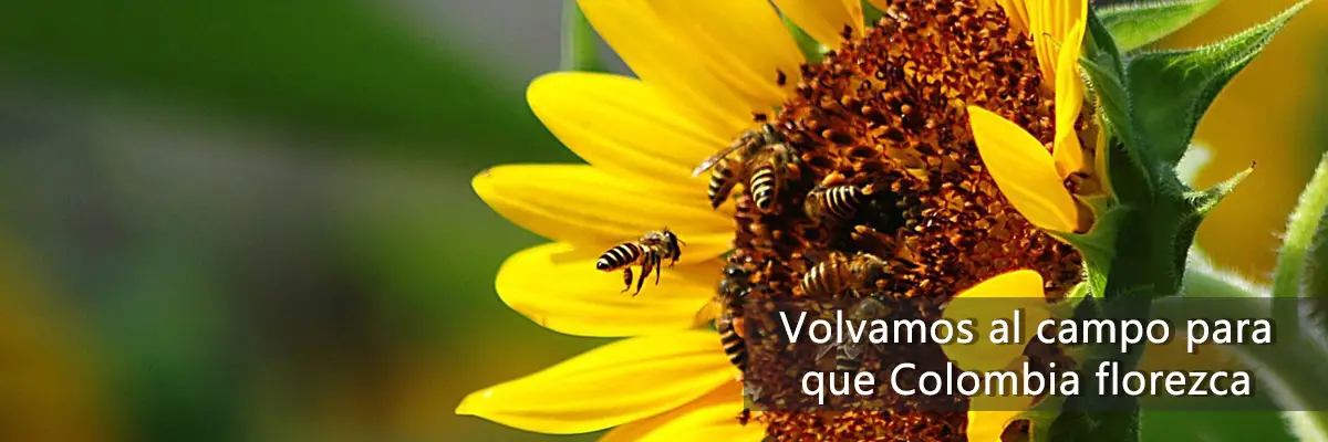
Although they are treated as weeds, they fulfill an important function: their ability to grow in all types of environments and their resistance to drought allows them to invade degraded sites, where they detain the soil. Also, because they produce a lot of nectar, they attract numerous pollinators, such as bees. 

Origin of Sunflowers

Indigenous domestication

Sunflowers were domesticated by Mesoamerican Indian tribes, and are traditionally associated with pre-Columbian Mexican cultures. They were cultivated more for their usefulness than for their beauty.

However, the sunflower was used as a symbol representing the sun deity, primarily by the Aztecs and Otomies in Mexico and the Incas in Peru.

In 1532, Francisco Pizarro entered Peru, where he found a gigantic sunflower that the indigenous people of the Inca empire worshipped as a sacred image of the sun god. Then, gold figures of this flower, as well as seeds, were taken to Europe at the beginning of the 16th century.

Crops and Sunflower Tourism

Nowadays, their cultivation for oil extraction has been widespread in Spain since about 1980, thanks to subsidies from the European Economic Community. The same happens in the United Stated.

However, this is not the only appeal of sunflowers; the beauty of their fields attracts millions of tourists around the world.

Today there are sunflower fields on every continent, but the sunflower fields in Spain and Italy are the most famous for their unparalleled beauty.

The most beautiful sunflower fields in Spain are those found in the regions of La Bureba in Burgos, Cardejón in Soria, Carmona in Seville and Antequera in Malaga.

On the other hand, the most famous sunflower field in Italy is in the Tuscany region.

Sunflower Movement

Every day, sunflowers move towards the sun, following it on its east-west route. At night they move in the opposite direction, as if waiting for the sun to rise the next morning.

But one day they stop doing so, since when they reach maturity they stop their dance, do not turn again and remain oriented indefinitely towards the east until they die.

This movement, called heliotropism, is regulated by the circadian rhythm of the plants, and favors their growth.

And the truth is, it is not the flower that turns, it is the uneven growth of its stems that causes the turning. And when they stop growing, they stop turning.

That they stop is not entirely sad, since when they reach maturity, the plant is ready to be pollinated. The flowers release additional heat, which makes them more attractive to pollinating insects.

Find out more in the Science Report Circadian regulation of sunflower heliotropism, floral orientation, and pollinator visits: Sun-tracking when young, east-facing when mature, warmer sunflowers attract more pollinators.

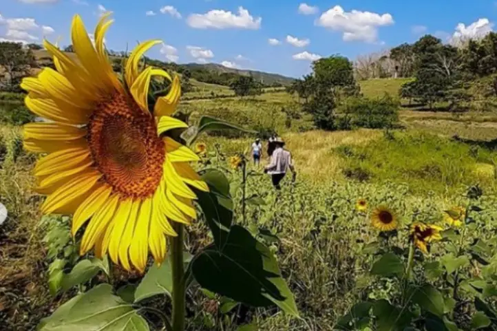
Sunflower Tourism in Colombia

Research on sunflower cultivation in Colombia has been carried out since the late 1950s. But it was not until 1985 that the first sunflower field was planted for commercial production. The first crops were planted in Valle del Cauca, Tolima and Cesar.

In general, sunflower grows well in Colombia, from sea level to 2600 meter above sea level, so much so that today there are crops in Bogota. However, it was not until 2020 that some fields began to be used for tourism.

Today, there are several destinations where you can visit sunflower fields in Colombia, bu today I am goiong to talk about the most suitable for visit: San Martin, in the department of Meta, in the eastern plains of Colombia, Montes de Maria in the department of Bolivar, in the Colombian Caribbean region, and Valledupar in the department of Cesar, also part of the Caribbean region.

Sunflower Tourism in San Martin, Meta

Sunflower Tourism in San Martin de Los Llanos, Meta, Colombia CC @campodegirasolessm

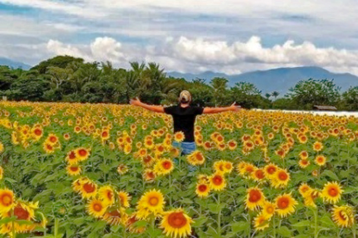
The municipality of San Martin de los Llanos is located one hour from Villavicencio, capital of Meta. The annual sowing of sunflowers in a private plot of land in San Martín de los Llanos is the place that delights the visitor’s eyes with a minefield of this plant.

For more than five years, between the months of October and November, the sunflower crop blooms, and every year tourists are treated to the experience of walking among a crop of large and impressive sunflowers.

The tour starts at 10:00 in the morning or at 3:00 in the afternoon, from the municipality of San Martin with the indications of the authorized guides.

To get there you have to cross a 3-kilometer dirt road from San Martin; since it is private land, it is not permitted to indicate the exact location of the place.

Sunflower Tourism in Montes de María (or Serranía de San Jacinto), Bolívar

Sunflowers in San Jacinto, Bolivar, Colombia. Pic. by @yulart__

Between the departments of Bolívar and Sucre, in the Colombian Caribbean, is located the sub-region of Montes de María, a vast territory of agricultural and livestock tradition whose geographical location consolidated it as a corridor that connects a large part of the country with the Caribbean region and some of its main ports.

The Montes de María (also known as Serranía de San Jacinto) length does not exceed 110 km and its altitudes are less than 1,200 meters above sea level.

Montes de María, a Post-conflict Destination

The Montes de María area suffered from conflict for years, being a zone of FARC-EP guerrilla activity and paramilitary groups including the AUC. A particularly difficult period was in the late 1990s and early 2000s.

For years, this territory was forgotten, but now it is reappearing to conquer Colombians and foreigners with its beauty. In addition to the handicrafts, bagpipes and natural landscapes, there is a sunflower field, which has become another tourist attraction.

Tourism, entrepreneurship and sustainability

In the Sibar farm there is fish farming, chicken breeding and now, beekeeping that began to be generated thanks to the planting of these sunflowers.

It is an eco-efficient farm, where nothing is thrown away. The chicken feces (chicken manure) are used as fertilizer for the sunflowers. The flour from the sunflowers is fed to fish and chickens.

Bee Keeping Crops: The company AgroFrance sold the sunflower seeds to the farm owners

Sibar Farm and its Sunflower Fields

The idea arose as a result of the pandemic. Originally, it was a soy-based poultry feed manufacturing company. Due to the covid-19 pandemic, they came up with the idea of using sunflower meal as raw material for concentrate plants for cattle, sheep, swine, fish and poultry feed.

The company AgroFrance sold the sunflower seeds to the farm owners, and gave them technical assistance for planting, which is how the three-hectare sunflower field was born.

This sunflower variety produces grains with high protein, vitamin and fiber content, which have different uses for human consumption. These characteristics make this field even more special for tourists.

The field is located on the Sibar farm, on the outskirts of the municipality of San Jacinto, and very close to the Troncal de Occidente highway in the Montes de María.

Entering to contemplate the 180 thousand sunflowers has no cost. The only recommendation of the owner Alfredo Villadiego is that the visit is made with all the biosecurity protocols and without making noise because they can scare the bees!

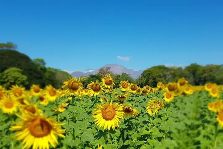
Sunflower Tourism in Valledupar, Cesar

Sunflower Fields in Valledupar, Cesar, Colombia CC Publimetro.co

The cultivation of sunflower in the department of Cesar arose thanks to the union of several farmers. As in Bolivar, AgroFrance International distributed the seed to the local agricultural farmers.

The crops are located on the road that leads to the village of El Jabo, five minutes from Valledupar, at Finca La Esmeralda, and there are other fields distributed in the village of Los Venados, and in the municipality of Urumita in La Guajira.

Sunflower as an Alternative Crop

Sunflower cultivation in Cesar has become a planting alternative due to the scarce markets for rice, corn, cotton, sorghum, and other products, and it is a plant that does not require abundant water. Farmers in the area hope to harvest the grain to take it to agribusiness as oil or flour.

Bee sanctuary, therapeutic and tourist attractiveness

The harmonious and constant buzzing of bees accompanies this yellow feast, making it a sanctuary for bees. Thousands of bees arrive in swarms from the mountains to give life to the crops and help the pollination of this plant.

Some countries such as Germany, Austria, Denmark, Spain, Belgium, France and Greece must implant bee hives, artificially, due to the scarcity of this insect in these countries.

One of the owners of the crops has witnessed how hundreds of people come to appreciate these flowers, and for the landscape impact of 200 thousand sunflower plants framed under the silhouette of the Sierra Nevada de Santa Marta, which for some resembles Swiss landscapes.

The fields have even been visited by several people with health problems to enjoy the beauty of the crop. In this way, they are contributing to the community.

Important Precautions When Visiting a Sunflower Field

  • You should wear appropriate footwear for the tour and the mud.
  • Avoid wearing strong perfumes before visiting, as they attract bees.
  • In addition, it is recommended not to run inside the field and it is forbidden to cut the sunflowers.

Remember, these places are especially for those who wish to enjoy nature.

If you want to know more about nature and agro-tourism destinations in Colombia do not hesitate in contact us or visit our Plan your trip page.

References
About the authors

Sara Colmenares

The current director of Sula. Doctor in Biological Sciences. Her main interests are to explore and understand the organism-environment interactions, taking advantage of emerging knowledge for the management and conservation of species and ecosystem services. She is currently working as a consultant in functional ecology, ecosystem services, and conservation projects in Colombia related to ecotourism and birdwatching.

How Your Visit to Sierra de la Macarena in Colombia Helps for its Conservation?

La Macarena is a municipality located in the department of Meta, Colombia, with natural reserves such as the Sierra de la Macarena Natural National Park which has become internationally known for the seven colors river, Caño Cristales.

The sierra also has petroglyphs of ancient cultures in the Angosturas I and II sectors, in the Guayabero River. There are also enormous waterfalls, such as the Caño Canoas Waterfall, the Yarumales Waterfall, the Mico Waterfall, Soplaculos among others, which are difficult to reach due to the steep terrain.

This region of Colombia has been hard hit by the armed conflict, the planting of illicit crops, extensive cattle ranching and large-scale deforestation. Even after the signing of the peace agreement, it is a territory that continues to undergo a slow process of re-organization of the territory and the role of the people who inhabit it.

Ecotourism and community-based tourism is one of the lines that the local community is developing, taking advantage of the impressive natural wealth of the territory. Plans include the creation of ecological trails where visitors can also participate in the restoration process by planting a tree.

They also want to promote other destinations that activate tourist visits at times other than Caño Cristales, and thus have an income derived from tourism activity throughout the year.

Sierra de la Macarena is a Territory of Great Value for Humanity

The Sierra de La Macarena National Natural Park is located in the department of Meta, in a strategic location where the Andes, the Orinoco Savannah, the Guyanese Shield and the Amazonian plain converge, giving it a hyper mega biodiversity character, a true biological heritage for humanity.

The protected area also connects with the Tinigua and Picachos National Parks.

Sierra de la Macarena

The Sierra de la Macarena is an isolated mountain range that due to its nature, location and type of soil is home to endemic species of flora and fauna, that is to say that only exist in that place. An example of these is the aquatic plant Macarenia clavijera, which gives the reddish, pink and greenish colors to Caño Cristales, the region’s tourist destination par excellence.

Eighty-three percent of the Macarena mountain range is made up of humid forest (tropical humid zone) with an area of 5030 km², in addition to the herbaceous vegetation of the Amazon plain. La Macarena is considered worldwide as one of the most important wildlife refuges on the planet.

Thus, this natural treasure has extraordinary landscapes that are world icons such as the above mentioned Caño Cristales, as well as unique species such as the cumin tree (Aniba perutilis), the jaguar (Panthera onca) and the tapir (Tapirus bairdii).

Sierra de la Macarena National Park, Colombia Picture by Parque Nacionales

Effects of the Armed Conflict and the Peace Process in La Macarena

During the 1970s, the Macarena sector experienced an increase in population due to the fur trade and foreign tourism, but unfortunately, in the 1980s, the logging boom began. Besides that, for more than 40 years La Macarena and surrounding municipalities were occupied by blocks of the former FARC-EP guerrilla and other armed groups in constant conflict.

Guerrilla occupation generated many displacements and a difficult task for the conservation processes of the National Park System and non-profit organizations such as WWF. In fact, no inhabitant could move freely without a mobility permit issued by the FARC.

At the same time, this territory has been the scene of territorial and socio-environmental conflicts related to land ownership, extensive cattle ranching, deforestation, illicit crops, and the presence of armed actors. Despite the efforts and hope brought about by the Peace Agreement, disputes and conflicts in this region were reconfigured and exacerbated after its signing in 2016, increasing the challenges for the conservation of these strategic ecosystems and for peace building in the communities.

Community Actions for Conservation

In the midst of this complex context, some small farmer families living in the Sierra de La Macarena have decided to make a commitment to conservation and are now participating in ecological restoration processes with the production and planting of native tree species, and with ecotourism entrepreneurship.

Tourism appeared as a saving option. Today, in fact, it is for 350 families who live directly from the income generated by this activity. People who work in simple but clean hotels, cooking for tourists, as guides, canoeists, and drivers. Even translators, although so far they only have three who speak English.

Thus, the Ministry of Commerce, Industry and Tourism (MinCit) o Colombia has generated strategies to promote sustainable tourism and support the communities of La Macarena.

Sierra de la Macarena National Natural park

Sierra de la Macarena NNP is in the department of Meta, in the Andean foothills of the Amazon rainforest. In this part of the country, the Andean, Amazonian and Orinoco ecosystems converge, and it has a territorial extension of 10,000 km².

This protected area was created by Decree 1989 of September 1, 1989 and covers an area of 605,793 hectares distributed in 5 municipalities in the southern part of the department of Meta.

The park’s Environmental Management Plan incorporates an ecotourism management plan, which indicates the possible scenarios for this activity. Currently, there are only two characterized scenarios with defined carrying capacity and regulations: Caño Cristales and Raudal Angosturas 1.

Other scenarios have been identified but are not yet regulated for visits, including the La Paz Ecological Trail, the Santo Domingo and Cafetales waterfalls in Mesetas and San Juan de Arama, as well as Raudal II near Puerto Concordia. Thus, these areas cannot be visited because they are still in the process of being organized.

Tourist attractions of Sierra de la Macarena National Natural Park

Today it is possible to visit Caño Cristales with its new trails and the Raudal Angosturas I, thanks to the articulated work that has been carried out since 2014 with the creation of the Mesa Ruta Sierra de la Macarena and the need to expand the supply of ecotourism trails in the Caño Cristales sector, as well as to carry out sufficient technical procedures to implement new ecotourism scenarios that will involve a larger population in the community benefits of tourism in the municipality of La Macarena.

Caño Cristales, the Rainbow River

Cano Cristales, La Macarena, Meta, Colombia.

The Macarena’s most recognized attraction in the area is Caño Cristales, better known as “the river of the five colors”, “the most beautiful river in the world” or “the river that escaped from paradise”; one poet even called it “the rainbow that melted”.

Macarenia clavigera, an aquatic plant endemic to the Macarena, is what allows the river’s crystalline and shallow waters to offer a variety of colors that visitors can appreciate. The extension of the river does not exceed 100 kilometers and has a width of no more than 20 meters, which flows into the Guayabero River. The trails established to learn more about this beautiful place are five circuits of stone and plants, ranging from 3 to 15 kilometers in length.

For more information about Cano Cristales visit our entry Travel Guide to the Rainbow River – Caño Cristales – in Colombia.

Raudal de Angostura I and Ciudad de Piedra

Raudal de Angosturas, La Macarena, Meta, Colombia.

The Raudal Angosturas I destination opened in 2017, as a new ecotourism scenario for the enjoyment of tourists from Colombia and the world. It is a project where you can appreciate the pre-Columbian petroglyphs carved in rocks in low relief that tell the story of the ancestors of the Tinigua tribe when they lived in this area. In turn, Ciudad de Piedra is a trail composed of huge gray rock formations carved over centuries by the force of water.

Many local and national organizations worked together to create this tourist destination, among them, National Natural Parks of Colombia, Cormacarena, the Governor’s Office of Meta, the Mayor’s Office of La Macarena and other members that are part of the Technical Tourism Board: Sierra de la Macarena Route.

Raudal Angosturas I is located between the border of the Sierra de la Macarena and Tinigua National Parks and in the Recovery Zone for Southern Preservation in the municipality of La Macarena, Meta.

This natural wonder contains engraved in its petroglyphs the history of the Tinigua Indians and also the footprint of the armed conflict in Colombia.

The Military Forces of the region support this process of ecotourism management, since it will ensure the safety of those who will enjoy nature tourism in the Macarena Special Management Area.

If you wish to visit the other tourist attractions, you must have a guide specialized in the area, but you must inform the park facilities in the municipality of Granada, Meta.

How to get to Sierra de la Macarena National Natural Park

The following alternatives are the most time efficient, as it is possible to arrive by land but the time will be longer, and probably not safe.

Via Bogotá – La Macarena

Take a 1-hour flight from El Dorado International Airport (BOG) Bogotá to La Macarena Airport (LMC) at La Macarena city with Satena airline. There are also private charter flights that take you there.

Via Cali – Villavicencio – La Macarena

Take a 1-hour flight from Alfonso Bonilla Aragón International Airport in Palmira to Vanguardia Airport (VVC) at La Villavicencio city. Once at the airport, take an approximately 1- hour ride to La Macarena.

What to do in Sierra de la Macarena National Natural Park

Hiking in La Macarena

There are 6 ecotourism trails allowed, which can be done walking or with the help of a horse, and are distributed as follows:

Caño Cristales Ecotourism Scenario, Colors subarea:

  • Salto del Aguila: the number of people allowed daily is 75.
  • Los Pianos: the number of people allowed per day is 62.
  • Caño Escondido: the number of people allowed per day is 37.
  • Intermedio: the number of people allowed per day is 42.

In this scenario you can appreciate the landscape, characteristic vegetation, geological formation, waterfalls, natural pools, aquatic plants (Macarenia clavijera) red, fuchsia and pink; in addition to bird watching.

Scenario Raudal de Angosturas I

  • Ciudad de Piedra: the number of people allowed daily is 37.

In this trail you can do bird watching tour geological formation and rocky outcrop, in addition to the Caño with red plants.

Scenario Mirador Cristalitos

  • Mirador-cristalitos: the number of people allowed daily is 87.

This trail has pictograms, a panoramic view of the convergence of the three ecosystems along its route.

Bear in mind that the trails mentioned above are only authorized by the environmental authorities o the park and may have variations in the routes, which visitors will be informed of when registering. You cannot choose the trail to visit, it is assigned by the authorities and given in order of registration.

Birdwatching at Sierra de la Macarena

There are more than 450 bird species registered in the la Macarena, represented in 65 families, which means that 27% of the Colombian avifauna is present in the park. Dominant bird species are from the Guianas, Amazon and, to a lesser extent, the Andean region.

The following bird species have been recorded from the Amazon: Paroaria gularis gularis, Piaya melanogaster, Electron platyrhynchum pyrrholaemum; from the Andes: Asio flammeus, Trogon personatus personatus, Campephilus pollens, Cistothorus platensis tamae; migratory birds from North America: Anas discors, Pandion haliaetus carolinensis, Actitis macularia, and Coccyzus americanus americanus.

Where to stay in Sierra de la Macarena National Natural Park

Sierra de la Macarena Natural National Park does not currently offer accommodation for travelers, it is possible to stay in La Macarena. Our recommendation of hotels are is La Manigua Lodge, a beautiful ecolodge recently installed in the area. Know more about ecolodges in Colombia in our entry Complete Guide to the Best Eco lodges in Colombia.

Best time to visit Sierra de la Macarena National Natural Park

The main attraction of La Macarena, Caño Cristales, only receives visitors during the winter season, that is, between June and December; for the summer season the community allows the aquatic plants to recover. However, Raudal de Angosturas I is open all year round.

Dry season on the eastern side of La Macarena starts at the beginning of December until late of February at a temperature of 24º C (75 ºF). On the western side the rainfall regime is bimodal, it also has 2 dry periods separated by rainy seasons.

Sierra de la Macarena National Natural Park Entrance fees

The entrance fee varies depending on the nationality and age of the visitors. These are the entrance fees for 2021:

  • Colombians, resident foreigners and tourists from Bolivia, Ecuador and Peru (ages 5 to 25): COP 19,500
  • Colombians, resident foreigners and tourists from Bolivia, Ecuador and Peru (over 25 years old): COP 35,500
  • Non-resident foreigners (over 5 years old): COP 53,500
  • Children under 5 years old and Colombians over 65 years old have free entrance presenting their IDs.

What to consider before visiting Sierra de la Macarena National Natural Park

  • To take any of the tours inside the park you must hire an authorized and certified guide.
  • Consider wearing personal protective items (sunscreen, sunglasses, insect repellent, and hat).
  • The use of flash when taking photographs is prohibited.
  • Use of binoculars to watch animals’ behavior is recommended.
  • Bring along valid identification documents and health insurance.
  • It is recommended to be vaccinated against yellow fever and tetanus.
  • If you take specific medications, take them with you a personal first aid kit.

Some prohibitions

Feeding, bothering or hunting animals, alcoholic drinks and drugs, throwing cigarette butts, burning garbage, felling, and capturing wildlife.

References
About the authors

Sara Colmenares

The current director of Sula. Doctor in Biological Sciences. Her main interests are to explore and understand the organism-environment interactions, taking advantage of emerging knowledge for the management and conservation of species and ecosystem services. She is currently working as a consultant in functional ecology, ecosystem services, and conservation projects in Colombia related to ecotourism and birdwatching.

Luisa Martin

Engineer, world traveler, amateur photographer, traveling blogger, and foody.

The Eight Wonder of the World at El Tuparro National Natural Park

A vast green savannah, large rivers, golden beaches, gallery forests and crystal clear waters is what you will find in the Tuparro National Natural Park, a jewel in the heart of the Orinoquia. In this publication you will find important information for your visit to Tuparro National Natural Park in Colombia.

Discovering Tuparro National Natural Park

El Tuparro National Natural Park is located in the Orinoco region of Colombia, and it is part of the department of Vichada. The Tuparro park is bathed by the Tomo River to the north, and the Tuparro, Tuparrito and Caño Maipurés rivers to the south.

Its landscapes expresses in its forms a typical image of the so-called Guiana Shield, one of the oldest geological formations of our planet shared by Brazil, Colombia, Venezuela and, of course, the Guianas.

Tuparro Biosphere Reserve of the World

The park was created in 1970 to advance scientific studies and conserve the region’s biodiversity. This led to its declaration as El Tuparro National Natural Park in 1980 with 548,000 ha. The cultural and biological richness of this region made it worth to be declared a national monument, and core area of a Biosphere Reserve. Know more about biosphere reserves of Colombia in our entry Next Travel Ideas? Visit the Biosphere Reserves of Colombia.

It is also considered an Important Bird Area (IBA) site because it is estimated that there are more than 320 species of birds, many of them associated with the water bodies.

A Sanctuary for All

The park is a sanctuary for birds, orchids, monkeys, snakes and toninas (pink freshwater dolphins). There is also an ancient cemetery that belonged to the Maipur indigenous nation, which is now extinct.

Besides, there are indigenous communities surrounding the protected area: Piaroa, Curripaco, Cuiba, Puinave and Guahibo, who preserve and maintain their traditions amidst the park’s tourism.

What does it mean Tuparro?

This park owes its name to the Tuparro River. Tuparro is the name given to the small hills, rocky outcrops, of less than 900 m. high, which are remains of the ancient Guyanese shield, composed of quartz and currently considered one of the oldest mountains on the continent.

The Raudales de Maipures on the Orinoco River and at the mouth of the Tuparro River, is one of its main attractions. The Orinoco river narrows in this area and its current flows thunderously between giant rocks that extend up to 5 km.

How to Get to Tuparro National Natural Park

Via Bogotá-Puerto Carreño

Take a 1-hour flight from El Dorado International Airport (BOG) Bogotá to German Olano (PCR) at Puerto Carreño city with Colombia´s state own airline: Satena.

Once at the airport, take an approximately 45- minutes ride to Casuarito Port. Once at the Port you should take an extra 10-minutes boat ride to Puerto Ayacucho (Venezuela). Finally in Puerto Ayacucho you should take an extra 15-minutes boat ride to Tuparro.

Via Bogotá- Villavicencio

Take a 1,2-hours flight from El Dorado International Airport (BOG) in Bogotá to Vanguadía Airport (VVC) at Villavicencio city with Satena Airline. In the airport take an approximately 1h1min flight to to German Olano (PCR) at Puerto Carreño city with Satena Airline.

Once at the airport, take an approximately 45- minutes ride to Casuarito Port. Once at the Port you should take an extra 10-minutes boat ride to Puerto Ayacucho (Venezuela). Finally in Puerto Ayacucho you should take an extra 15-minutes boat ride to Tuparro.

What to do in Tuparro National Natural Park

During the induction talk, visitors are informed about the activities carried out in El Tuparro National Natural Park, the conservation objectives, the services offered, and the ecotourism activities that can be carried out.

Hiking and Trekking

Hiking is the most exciting activity in Tuparro National Natural Park. The Attalea (Maipures) trail has a length of 3 km uphill through a palm forest and rocky outcrop. Moderate intesity. When you reach the highest point you can have the view of the Raudal Maipures. This trail is currently being managed by local indigenous communities.

The Eighth Wonder of the World Tuparro Natural Park

The Raudal de Maipures and the Balancín

Formerly called Quituna by the indigenous people of the region, the waters of the Maipures raudal belong to the great Orinoco River. There, this riverbed marks part of the extensive border limits that separate Colombia and Venezuela.

Maipures is one of the most impressive attractions that El Tuparro National Natural Park offers to its visitors. In the 19th century, specifically in 1800, the famous German naturalist Alexander von Humboldt passed through the Maipures stream. He called this place “the eighth wonder of the world”. Among its main attractions, undoubtedly, is the “Balancín”, in the sector of the Atarrayadero, a rock that remains suspended over another, despite the strong currents with which the great Orinoco lambastes there.

The best time to enjoy all the splendor that Maipures offers is during the summer months (low water season due to the few rains that fall in this region), that is, between the months of December and March.

Birdwatching and Wildlife Tours

El Tuparro National Natural Park is a perfect place for those interested in fauna and flora. However, it is not easy to spot wildlife because most of them have crepuscular habits (dawn and dusk) and are elusive.

Birdwatchers will be able to enjoy some of the species since there are records of more than 300 species of birds. Research and monitoring have found 74 species of mammals, 17 species of reptiles, 229 species of fish, and up to 828 species of plants in the protected area. Insects have not yet been surveyed, so all the data that you document during your visit (citizen science) will be of help to continue to nourish the park’s lists.

The main ecosystems present in the park are typical of the Orinoco, including dry and flooded savannah, gallery forests, riparian forests, and rocky outcrops.

Aquatic Tourism

Finishing the hiking activity through the Anaconda trail, you can go through a path in the savannah where meters ahead the visitor will find the attractive blue well, ideal for a refreshing swim. The bathing activity can also be developed in the attractions of Bocas del Tomo, Raudal del Tuparro and caño Peinillas. Kayak can also be practiced in the Raudal del Tuparro.

El Tuparro

Research and Environmental Education

The protected area’s exuberant biodiversity and its conservation status make it a suitable place for scientific research. In addition, activities related to the Environmental Communication and Education Plan are carried out in coordination with educational institutions and in the development of the lines prioritized for the fulfillment of the institutional mission.

Where to stay in Tuparro National Natural Park

Tuparro Natural National Park does not currently offer accommodation for travelers, but it is possible to stay in Puerto Carreño. Therefore we recommend the following hotels:

  • El Lago
  • Cacique Samanare
  • Voragine

Best Time to Visit Tuparro National Natural Park

The best time to visit El Tuparro is the dry season which starts at the beginning of June until late of September and from the beginning of April until late of November, with temperatures around 25º C (77 ºF).

Tuparro National Natural Park Entrance fees

The entrance fee varies depending on the nationality and age of the visitors. These are the entrance fees for 2021:

  • Colombians, resident foreigners and tourists from Bolivia, Ecuador and Peru (ages 5 to 25): COP 10,000
  • Colombians, resident foreigners and tourists from Bolivia, Ecuador and Peru (over 25 years old): COP 16,000
  • Non-resident foreigners (over 5 years old): COP 46,500
  • Children under 5 years old and Colombians over 65 years old have free entrance presenting their IDs.

Before Visiting Tuparro National Natural Park Consider:

  • The entrance of Visitors only will be allowed if it is accompanied by an authorized touristic operator that meets the law requirements, the visitor who enters the park without a touristic operator will be returned by the Staff of the protected area.
  • Due to the security of the visitors and uncomfortable situations that have been presenting with our neighboring country, national parks authorities recommend not traveling to Venezuela.
  • You should avoid taking harmful elements that go against biodiversity, such as aerosols, guns, alcoholic beverages and hallucinogen substances.
  • The staff of the Park reserves the right of entrance and/or permanence to the people that are not mentioned in the entrance permit, this measurement also works for the cases when the total number of people does not matches the number indicated in the permit.
  • Due to evacuation of BIODEGRADABLE trash (bottles, batteries, cans, etc.), it is necessary to carry plastics bags.
  • If you enter through Venezuela, you must do so through a registered tour operator and under their security.
  • Consider wearing personal protective items (sunscreen, sunglasses, towel, insect repellent, and hat).
  • Bring along valid identification documents and health insurance.
  • It is recommended to be vaccinated against yellow fever, measles and tetanus.
  • If you take specific medications, take them with you a personal first aid kit.
  • Photos or videos for commercial or publication purposes must have prior permission from Parques Nacionales. The use of DRONES is not permitted in the Protected Areas for filming and/or photography activities of a private-recreational nature, without prior authorization.

Some prohibitions

Feeding, bothering or hunting animals, alcoholic drinks and drugs, throwing cigarette butts, burning garbage, felling, and capturing wildlife.

References
About the authors

Sara Colmenares

The current director of Sula. Doctor in Biological Sciences. Her main interests are to explore and understand the organism-environment interactions, taking advantage of emerging knowledge for the management and conservation of species and ecosystem services. She is currently working as a consultant in functional ecology, ecosystem services, and conservation projects in Colombia related to ecotourism and birdwatching.

Luisa Martin

Engineer, world traveler, amateur photographer, traveling blogger, and foody.

Best places to see Anteaters in Colombia

The terror of ants and termites also lives in Colombia. They are creatures with a docile character and poses no threat to man. On a tailored wildlife holiday with SULA, you have a good chance to see anteaters in Colombia, such as the Giant Anteater (Myrmecophaga tridactyla) and the Tamandua, or lesser anteater (Tamandua tetradactyla). They can often be found in savannas, and open grasslands, where the termites upon which they feed are abundant.

The Anteaters

The South American anteater is an animal that has a tongue similar to that of a long worm, which is why it is classified in the suborder Vermilingua, which literally means “worm tongue”. The anteaters are predators specialized in eating insects, especially ants and termites.

Anteaters are distant cousin of sloths and armadillos, and contrary to what you may think, they have nothing to do with aardvarks, numbats, echidnas, pangolins, and some spiders, which are also called anteaters.

Anteaters are endangered species, rice crops, African palm plantations, and livestock are the main causes of displacement of the anteater from its natural habitat. Forced displacement affects their diet and their reproduction rates decrease; in addition, anteaters may be run over by vehicles or face other problems with humans.

Ecotourism is a source of income to promote their study and conservation.

Anteaters Species

There are four species of anteaters still alive: the silky anteater (Cyclopes didactylus), the giant anteater (Myrmecophaga tridactyla), the northern tamandua (Tamandua mexicana) and the southern tamandua (Tamandua tetradactyla).

Silky anteater – Cyclopes didactylus © Tinka Plese – Rojano, C., Miranda, L., Ávila, R. (Editores). 2014. Manual de Rehabilitación de Hormigueros de Colombia. Fundación Cunaguaro, Geopark
Colombia S.A.S. El Yopal, Casanare. 155 p
Anteaters in Colombia, in this picture the Giant anteater –Myrmecophaga tridactyla
Southern tamandua – Tamandua tetradactyla © M.Tello Rojano, C., Miranda, L., Ávila, R. (Editores). 2014. Manual de Rehabilitación de Hormigueros de Colombia. Fundación Cunaguaro, Geopark Colombia S.A.S. El Yopal, Casanare. 155 p

The difference between them lies mainly in the habitat in which they live, which includes tropical dry forests, rainforests, grasslands and savannas, although not in the Andean mountainous regions. The giant anteater lives in savannas. And that is where they can be found in Colombia.

As for the two anteaters of the genus Tamandua, and the silky anteater, they are much smaller than the giant anteater, their fur is yellowish, and they live in trees.

The Wold Anteater Day is celebrated on 29 November every year, reminding the importance of their conservation.

Where do Anteaters Live

Originally, these animals were exclusive to South America, but once the isthmus of Panama was formed about three million years ago, anteaters expanded their range to Central America.

Thus, giant anteaters can be found as far as Central America, while silky anteaters and northern tamanduas reach as far as Mexico. Southern tamanduas extend as far south as Uruguay.

There are several names for anteaters in south America, and they depend on the species. The giant anteater is called ant bear, “oso hormiguero” in Spanish, the silky anteater is also known as pygmy anteater, and for the tamanduas there are names such as tamanduá, guazú, yautare, kuarevachú, Oso Bandera, and Oso Palmero.

Where You Can Find the Anteater

Anteaters are widely distributed in South America and can be found in the following countries:

  • Argentina (Provinces of Formosa, Chaco, Misiones and Salta)
  • Bolivia
  • Brazil
  • Colombia
  • Costa Rica
  • Ecuador
  • Honduras
  • Nicaragua
  • Peru
  • Paraguay
  • Venezuela

7 Facts about Anteaters you cannot miss

  1. Anteaters can swallow a total of 35,000 ants and/or termites per day.
  2. The anteater tongue flicks 150 times per minute, and has thousands of tiny hooks and large amounts of saliva to eat ants or termites from trees and mounds.
  3. The anteater’s stomach is similar to a bird’s gizzard, using small amounts of sand and dirt to digest insects.
  4. Unlike other mammals, Anteaters don’t have teeth.
  5. Anteaters have a disgusting smell to defend themselves from their biggest predators, Puma and Jaguar, they also have long arched claws on their strong legs that may cause fatal injuries.
  6. Female gestation is of approximately 190 days. After birth, offspring are carried at the female’s back for 2 years, camouflaging themselves in the mother’s fur.
  7. They are one of the most ecological animals on the planet. Despite the large number of ants they consume, anteaters are very careful when eating and do not destroy the habitat of ants and/or termites.

Myths and Legends around the Anteaters

The anteater is perceived as a strange looking animal although it is viewed sympathetically and fortunately without culinary objectives. Its rarity and vulnerability, being so specialized in its feeding, promote it as a symbol of conservation, and also as a great attraction for nature tourism.

The anteater appears in several South American legends and stories, both indigenous and Creole. One of the most attractive is the one compiled by the writer Graciela Repún, which comes from the Kaingangá Indians of the jungle of Misiones (Argentina).

It seems that after the great flood, Kadjurukré, their creator god, worked at night to model with mud the animals of the jungle and when he was trying to finish the anteater, in a hurry because the sun was rising, he took a stick and put it in his mouth as a tongue because he did not have enough time to put teeth. And so he sent it to eat ants….

Where to See Anteaters in Colombia

The geographical distribution anteaters in Colombia is extensive. However, despite the wide distribution of anteaters in Colombia, the best place to watch them is in the Eastern Plains of Colombia.

There are several places to go in a Safari where it is possible to find these animals hanging around the savannas or the riparian forests. The best time to see the anteater is dry season between December and late March.

Here in SULA we offer a Safari that goes through Casanare an Meta departments, in the eastern plains of Colombia, where anteaters and other species present in this region can be spotted.

Casanare

Safari in Casanare

The conservation, education and research work of the Yopal-based environmental organization Fundación Cunaguaro includes anteaters. That includes monitoring the absurd number of road killings of these creatures – 400 giant anteaters a year and at least 1,500 tamanduas.

The foundation promotes ecotourism on large private estates, from where you can go out in search of the anteaters in Colombia.

El Encanto de Guanapalo

It is a group of cattle ranches which covers 9,000 hectares of inundable savannah and acts as a strategic wildlife corridor. El Encanto de Guanapalo Natural Reserve is conformed by 3 haciendas with a total area of 90 square kilometers, you can have a typical experience of the eastern plains, along with the conservation of the flora and fauna of the sector.

Wild horses and termite mounds at Casanare’s savannas.

Corocora Camp

Corocora Camp, Casanare, Colombia

Corocora Camp, the first luxury safari camp in Colombia. It is located two and a half hours from the Yopal airport by 4×4 vehicle. There you will find five large beige canvas tents, identical to those of the high-flying African safaris.

La Palmita Reserve

The municipality of Trinidad hosts La Palmita nature reserve, which has a research center that is responsible for acquiring knowledge of the biological and social diversity of the Orinoquia region for its conservation.

Meta

Find out more information about Meta anteaters destinations in our entry #1 Llanos Experience near to Bogotá: The Llanero Dawn Route in Meta.

Lagos de Menegua

Lagos de Menegua Hotel & Bioreserve

Mururito Nature Reserve

@Colombiafrank at Mururito

Recommendations for your visit

  • Take yellow fever and tetanus vaccines shot prior to arrival.
  • Do not forget that mosquito repellent is highly recommended.
  • Bring rubber boots, a raincoat, long-sleeved shirts, sunscreen.
  • Leave no trace.
  • Carry valid identity documents and health insurance.
  • If you take specific medications, take them with you.
  • It’s never too much to carry a personal medicine kit.

If you want to plan your trip to Colombia do not hesitate to contact us, visit our Plan your trip page!

References
About the authors

Sara Colmenares

The current director of Sula. Doctor in Biological Sciences. Her main interests are to explore and understand the organism–environment interactions, taking advantage of emerging knowledge for the management and conservation of species and ecosystem services. She is currently working as a consultant in functional ecology, ecosystem services, and conservation projects in Colombia related to ecotourism and birdwatching.

Luisa Martin

Engineer, world traveler, amateur photographer, traveling blogger, and foody.

Best Amazon River Dolphin Spots in Colombia ( A.k.a. Pink River Dolphin)

Dolphins are undoubtedly wonderful creatures, worthy of our affection and wonder. That is why many of us want to meet them in person. Moreover, true river dolphins, commonly known as the Amazon River Dolphin, the Pink River Dolphin, Tonina, or Boto, are much more attractive, mysterious, and charismatic. They are among the rarest and most endangered of all vertebrates in the world.

In this post, we will present you where to see the Amazon River Dolphins (Inia geoffrensis) or as many people call them, the pink dolphins, in Colombia.

Pink dolphin – Inia geoffrensis, picture by Fundacion Omacha

Amazon River Dolphin Facts

  1. The Amazon River Dolphin is the largest freshwater cetacean in the world, it manages to reach lengths of up to 2.80 meters long and a maximum weight of 200 kilograms.
  2. Its color varies depending on age, young dolphins and females show grayish colors while adults, and principally the males, turn pink, which gives them their characteristic name.
  3. There are many theories to explain its color, but many agree it is a result of the wear and tear of their skin, and some scars.
  4. Scientists discovered that river dolphins come from a very ancient lineage that inhabited the seas.
  5. Its behavior is very different from sea dolphins. They use to have a solitary life, sometimes in small groups composed of a maximum of four members.
  6. Their food consists of crabs, river turtles, piranhas, and other river fish.
  7. The pink dolphin is part of the folklore of the inhabitants of the Amazon and there are many legends and myths around this animal.

Myths and Legends around the Pink Dolphin

These legends generally attribute supernatural powers to the dolphins. One of the most famous legends tells that the pink dolphin was a young and very handsome indigenous warrior who awoke the envy of one of the gods for his masculine attributes.

This god decided to transform the warrior into a dolphin, condemning him to live in the rivers and lakes of the Amazon. It is said that the attractive dolphin dances perfectly and no woman can flee before his charms.

Pink Dolphins are Endangered Species

According to the classification of the International Union for Conservation of Nature (IUCN), the Amazon river dolphin is endangered, with only one category below the risk of extinction.

People kill them on behalf of their cultural traditions, or because they are competitors for fish. Other threats faced by the pink dolphin include accidental fishing, habitat loss, being killed for fish bait, and contamination.

With scientific research and responsible tourism, many people became aware of the importance of the conservation of these animals. In Colombia, NGOs as OMACHA and ECONARE are doing a great job to protect and conserve these animals.

Where You Can Find the Pink River Dolphin

These dolphins are widely distributed in South America and can be found in Brazil, Peru, Bolivia, Venezuela, Ecuador, and Colombia.

Scientists have not agreed on how many subspecies of pink dolphin exist, but certainly, they are not similar among the different regions. The IUCN recognizes three subspecies:

  • I. g. geoffrensis (Amazon river dolphin)
  • I. g. boliviensis (Bolivian river dolphin)
  • I. g. humboldtiana (Orinoco river dolphin)

While the Committee on Taxonomy of the Society for Marine Mammalogy only recognizes the first two of these.

Distribution map of all known species and subspecies of Inia. Black outline denotes the limit of the Amazon basin. Question marks denote uncertainty as to which species occurs in the Tocantins River downstream of the Tucuruí dam which potentially delimits the distributions of I. geoffrensis and I. araguaiaensis sp. nov. Bars on the Madeira River represent a series of rapids that delimit the distribution of I. geoffrensis and I. boliviensis. The single bar on the northern limit of the Amazon basin represents the Casiquiare canal which connects the Amazon and Orinoco basins, and is thought to delimit the I. g. humboldtiana subspecies from I. g. geoffrensis.
https://doi.org/10.1371/journal.pone.0083623.g001

To see how little is known about the pink dolphin, a relatively recent scientific study proposes a new species living in southeastern Brazil, the Inia araguaiaensis. They even propose the Bolivian subspecies should be recognized as a separate species, I. boliviensis. Take a look at the map above.

Where to See Pink River Dolphins in Colombia

Many people who contact us wanting to plan their trip to see the pink dolphin believe that it is only possible to see it in Leticia, the capital of the department of Amazonas in Colombia.

However, the Amazon as a region encompasses many more departments, not only the Amazon but also Vaupes, Guainia, Guaviare, Caqueta, and Putumayo.

On the other hand, all these departments are connected by a dense network of rivers and canals that run not only through Colombia, but all neighboring countries. And this is how the pink river dolphin manages to expand throughout the region.

Map of distribution of Inia geoffrensis in Colombia. ©Trujillo, F., Crespo, E., Van Damme, P.A. & J.S. Usma (Editors). 2010. The Action Plan for South American River Dolphins 2010 – 2020. WWF, Fundación Omacha, WDS, WDCS, Solamac. Bogotá, D.C., Colombia. 249 pp.

Thus, the pink river dolphin is not only distributed throughout the Colombian Amazon region but also reaches the eastern plains and the Guyanese shield, in the departments of  Amazonas, Putumayo, Caqueta, Vaupes, Guaviare, Guainia, Vichada, Meta, Casanare, and Arauca. Take a look at the map above to find your way around.

Despite its wide distribution, you can only visit a few places to meet the pink dolphin in Colombia.

Amazon river dolphin (Inia geoffrensis), also known as the boto, bufeo or pink river dolphin, Puerto Nariño

Amazonas

You can visit Leticia and Puerto Nariño on short boat trips along the Amazon river. However, we recommend you go to Puerto Nariño.

Puerto Nariño

The city of Puerto Nariño is the destination to see the river pink dolphins in the department of Amazonas. Here you have to navigate the Correo and Tarapoto lakes to see the wonderful pink dolphins up close.

Zacambu and the Three Frontiers

You can also depart from Leticia on a river tour on the majestic Amazon River. It is a tour towards the Zacambu village and the three frontiers region.

During the navigation through the river, you will be able to appreciate the flooded jungle. Arriving at the border with Peru, you will find Islandia (Peru), known as the Venice of the Amazon. This is a town that floods periodically, and that is why its houses are elevated as well as its streets. Once in the lakes of Zacambu, it will be possible to see river dolphins.

Where to Stay

Waira Suites Hotel – Leticia

Vichada

The department of Vichada is a known destination for sportfishing. However, it is also possible to go there and see the pink river dolphin. There the Meta, Bita, and Orinoco rivers converge, and there are tours in a boat to watch the pink dolphin departing from Puerto Carreno, the main city of Vichada.

Where to Stay

Carreño Plaza Hotel – Puerto Carreno

Meta

The “Ruta del Amanecer llanero” is the best way to see the pink dolphins in Meta. Visit our entry #1 Llanos Experience near Bogotá: The Llanero Dawn Route in Meta, to know more about this route.

The city of Puerto Gaitán, located 194 km south of Villavicencio, is bathed by the waters of the Manacacías river. Boat tours to watch the dolphins are an almost every day offer.

Puerto Gaitan is the most recommended destination if you do not have enough time to travel to far destinations such as Leticia, or Puerto Carreno. It is also the nearest to Bogota, the capital city of Colombia.

Where to Stay

Lagos de Menegua Hotel and Bioreserve

Mururito Natural Reserve

Guaviare

In the Nare Lagoon, very close to the city of San Jose del Guaviare, pink dolphins live and you will have the opportunity to swim with them.

There, with the help of local guides, you will learn the story of how they got there. You can also observe different species of fauna and flora throughout the tour.

With this trip, you will be directly helping the families that are part of ECONARE. Econare is a local association of community-based tourism in charge of preserving the nature of the area and the safety of the dolphins that inhabit the lagoon. You will also help all those people who make it possible for you to live these experiences.

Where to Stay

Quinto Nivel Hotel

How is a Pink Dolphin Tour?

Dolphins can only be observed from a certain distance on wooden platforms or in boats. Sportfishing adjacent to their hunting areas is prohibited and along with this, feeding them is forbidden as it would cause human dependence.

Best Time to Visit the Pink Dolphin

All year round in Colombia, especially in Guaviare and Meta.

Recommendations for your visit

  • Take yellow fever and tetanus vaccines before arrival.
  • Do not forget the mosquito repellent, it is highly recommended.
  • Rubber boots, raincoat, long-sleeved shirts, sunscreen.
  • Leave no trace.

If you want to plan your trip to Colombia do not hesitate to contact us, visit our Plan your trip page!

References
  • OMACHA Foundation.
  • Hrbek T, da Silva VMF, Dutra N, Gravena W, Martin AR, Farias IP (2014) A New Species of River Dolphin from Brazil or: How Little Do We Know Our Biodiversity. PLoS ONE 9(1): e83623.
  • Trujillo, F., Crespo, E., Van Damme, P.A. & J.S. Usma (Editors). 2010. The Action Plan for South American River Dolphins 2010 – 2020. WWF, Fundación Omacha, WDS, WDCS, Solamac. Bogotá, D.C., Colombia. 249 pp.
  • Status and conservation of river dolphins Inia geoffrensis and Sotalia fluviatilis in Colombia. Available from: https://www.researchgate.net/ [accessed Apr 15 2021].
About the author

Sara Colmenares

The current director of Sula. Doctor in Biological Sciences. Her main interests are to explore and understand the organism–environment interactions, taking advantage of emerging knowledge for the management and conservation of species and ecosystem services. She is currently working as a consultant in functional ecology, ecosystem services, and conservation projects in Colombia related to ecotourism and birdwatching.

The Ultimate Llanos Orientales of Colombia Bucket List

Over the last few years, Los Llanos Orientales has become a top favorite nature destination in Colombia. Travelers have fallen hard for the incredible landscapes, the safari experiences, the culture, and food.

With 16-17 million ha in the country, there is a long list of things you want to see and do. So I put together a bucket list with some of the most remarkable Colombian Llanos travel experiences and destinations.

From Caño Cristales in La Macarena to rafting in the Güéjar River Canyon, bird watching in Restrepo, aero-safari in Altagracia, horse riding and cowboy experience in El Encanto de Guanapalo, cocoa experience in Arauca, sport fishing in the Bita river in Vichada, glamping in the Corocora Camp to boating along the Manacacias River chasing dolphins in Meta— The Llanos Orientales is full of incredible adventures!

Here’s our ultimate Colombian Llanos Orientales travel bucket list!

Meta

Meta is one of the top bird watching destinations in Colombia. The multiple ecosystems you can find in Meta offer some of the most varied bird species checklists from the paramo to vast plains with echoes of the Amazon forest and parts of the Guiana Shield.

It also offers more than 47 festivals and cultural events throughout the year. The International Folkloric and Tourist Festival of El Llano is one of the most important and has the Cuadrillas de San Martín horse exhibition, which is Cultural Heritage of Colombia.

Another highlight for Meta is the Caño Cristales river, along with wonderful natural landscapes and adventure destinations. In Meta, you will have incredible gastronomic, cultural, wellness, nature and adventure experiences just a 20-minute flight from Bogotá. It is a great destination for those who have little time, or for those who travel with their families.

Top Experiences in Meta

La Macarena Mountain Range (Sierra de la Macarena): Caño Cristales Route

Caño Cristales – Creative Commons Wiki

Piedemonte Llanero Route: Birdwatching, Wellness and Horseback Experiences

Undulated Savanna – Mururito Nature Reserve

Llanero Dawn Route (Amanecer Llanero): Safari and dolphins

Manacacías River

Llanero Spell Route (Embrujo Llanero): Rafting at Rio Guejar Canyon

Travesía Aventura, Rio Guejar

More Bucket List Experiences in Meta

  • Birdwatching at UNAMAS Nature Reserve: Amazon jungle transition Orinoquia-Amazon
  • World Cowboy Meeting
  • 51st International Joropo Tournament.
  • Los Ocarros Biopark
  • Lomalinda Regional Natural Park
  • Guaicaramo Hot Springs (Barranca de Upía)
  • Ostrich Park
  • Las Malocas Park
  • Obelisk of Puerto Lopez

Casanare

Casanare is one of the top safari destinations in Colombia. The multiple nature reserves in the flooded plains of Casanare offer some of the best wildlife viewings in northern South America, especially during April and December.

Another highlight of Casanare is the cowboy’s rich culture. Discover the Cowboy culture in the Ranchón del Llanerazo, a museum that invites you to live the life of the Llanero man. There you will know the “Cantos de Trabajo del Llano”, which is a UNESCO Intangible Cultural Heritage of the world.

Top Experiences in Casanare

Aerosafari in the Colombian Plains

Aero safari – Altagracia Nature Reserve

Colombian Cowboy Experience

Cowboy Experience – Hato Los Deseos

Safari at Nature Reserves and Hatos

Safari in truck – Hato Matepalma

More Bucket List Experiences in Casanare

  • Birdwatching at La Primavera
  • Visit Corocora Camp for Luxury Glamping
  • Wildlife Photography tours
  • Gastronomy
  • Horseback Riding Expedition
  • Culture & Traditions
  • Conservation Experiences

Vichada

Vichada is the biggest department of the Colombian Llanos and is blessed with an incredible richness of water. It is the place where the Orinoco River forms its natural border between Colombia and Venezuela. From the spectacular El Tuparro national park to the mighty network of rivers, lagoons and canals and abundant wildlife – it’s the perfect destination for anglers and nature lovers.

To get to Vichada, you need an air connection since there is no direct road in good condition. You will find the airport of Puerto Carreño its capital, and also other airfields in other places in the department. You can also get there by boat, through the rivers that run on its territory: Orinoco, Meta and Vichada.

Top Experiences in Vichada

Tuparro Natural National Park

The Eighth Wonder of the World Tuparro Natural Park Colombiaamazinglandscapes / CC BY-SA

Streams of Maypures and Ventanas

Streams of Maypures and Ventanas © FishIn Colombia

Sportfishing at Bita and Tomo Rivers

Fishing in Puerto Carreño © FishIn Colombia

Bojonawi Nature Reserve

Bojonawi Nature Reserve

Pink river dolphin at Meta, Bita, and Orinoco Rivers

Bita River © FishIn Colombia

More Bucket List Experiences in Vichada

  • Hills of Casuarito
  • Orinoco and Bita Rivers beaches
  • Streams of Tuparro
  • Azul and El Pañuelo lagoons.
  • Peinillas Canal
  • Mesetas Canal
  • Rancho Barú and Rancho Wisi
  • Tomo, Tuparrito, and Tuparro rivers
  • Pedro Camejo Island
  • Guahibos and Cuibas Tribes
  • Maipures Indigenous Cemetery
  • El Unuma Indigenous Reserve
  • Gaviotas Center
  • Marandúa Project
  • Trekking

Arauca

Arauca is a diamond in the rough for nature and adventure tourism in Colombia. Its poor development is related to the presence of illegal armed groups. Here oil and livestock play an important role in the national economy.

In 2018, this area of Colombia was supported as a Tourism, Peace and Reconciliation zone with Creata Foundation, the Ministry of Foreign Affairs of Colombia, and USAID collaboration. However, despite the efforts, it is still a conflict zone in the country.

Its attraction lies in the richness of its landscapes. Its territory is divided into a mountainous part, an alluvial plain of the Orinoco, and the foothills of the plains with vegetation of savanna and tropical forest. Thus, the contrasts between mountains and plains offer you exotic landscapes and a great diversity of flora and fauna.

Top Experiences in Arauca

“Cotizas” of Arauca – handmade shoes and handicrafts

©Creata

Arauca Birding

©Creata

Cacao Experience

©Creata

Llanero Experience and Vaquería Songs

©Creata

La Barcaza: Boat trip on the Arauca River

©Creata

More Bucket List Experiences in Arauca

  • Cravo Norte
  • José Antonio Páez International Bridge
  • Las Toninas Aquapark
  • Arauca River
  • Los Morichales Park
  • El Alcaraván Experimental Farm
  • Rondon Port
  • Saravena
  • Tame

If you want to know more about Colombian nature tours, or want to visit the Llanos Orientales, follow us, write us comments, or just contact us.


References

  • www.mincit.gov.co
  • SITUR Meta
  • http://www.vichada.gov.co
  • Fundación Omacha

About the author

Sara Colmenares

Current director of Sula. Doctor in Biological Sciences. Her main interests are to explore and understand the organism – environment interactions, taking advantage of emerging knowledge for the management and conservation of species and ecosystem services. She is currently working as a consultant in functional ecology, ecosystem services and conservation projects in Colombia related to ecotourism and birdwatching.[/vc_column_text]