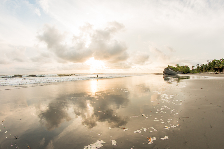
Known as the “Aldea de Piedras”, name given by the locals of the town. Jericó is on the list of “Network of Colombian Heritage Villages“, when you visit Jericó you will get to know its history and culture, the ecosystems and natural reserves, the gastronomy and local commerce.
In this guide you will have the necessary information to visit this adorable town.
Discovering Jericó
Jericó is in the southeast of the department of Antioquia. Bordered on the north by the municipalities of Tarso and Fredonia, on the east by the municipalities of Fredonia and Támesis; on the south by the municipalities of Támesis, Jardín and Andes and on the west by Andes and Pueblorrico.
Jericó was found in 1850 but there are records of its colonization since 1825. It is located approximately 108 kilometers southeast of Medellin.
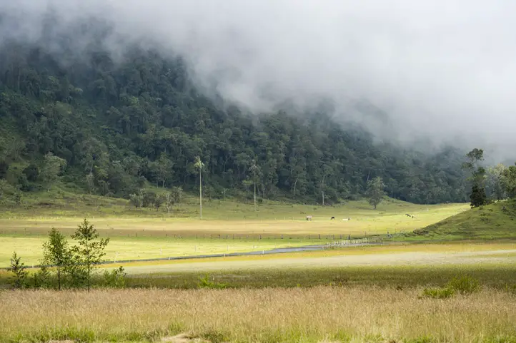
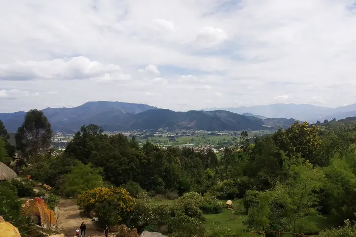
The town is known in Colombia for being home to a large number of churches and colorful streets which you will enjoy on your tour.
Bear in mind, the temperature generally ranges from 11 °C (51ºF) to 37 °C (98ºF). The best times of the year to visit Jericho for dry season activities are from mid-May to early July and from early September to late October.
How to get to Jericó
Take a 1,5-hours flight from El Dorado (BOG) in Bogotá to José María Córdova International Airport (MDE) at Rio Negro city.
Once at in Rio Negro you take an approximately 3-hours ride (108 Km) to Jericó.
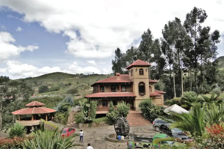
Where to stay in Jericó
In Jericó you will find numerous accommodation offerings for all budgets and personal tastes; our recommendations for you are:
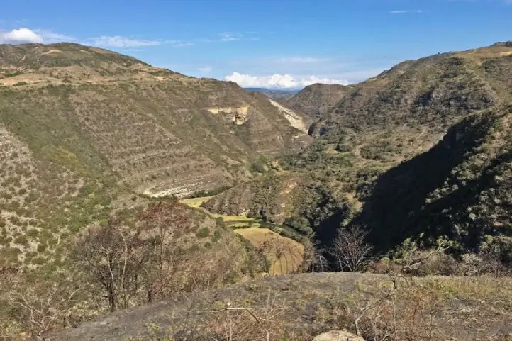
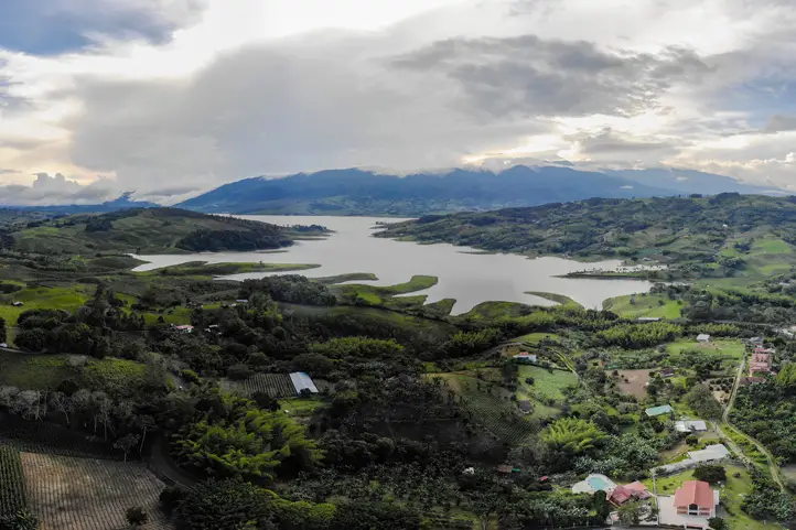
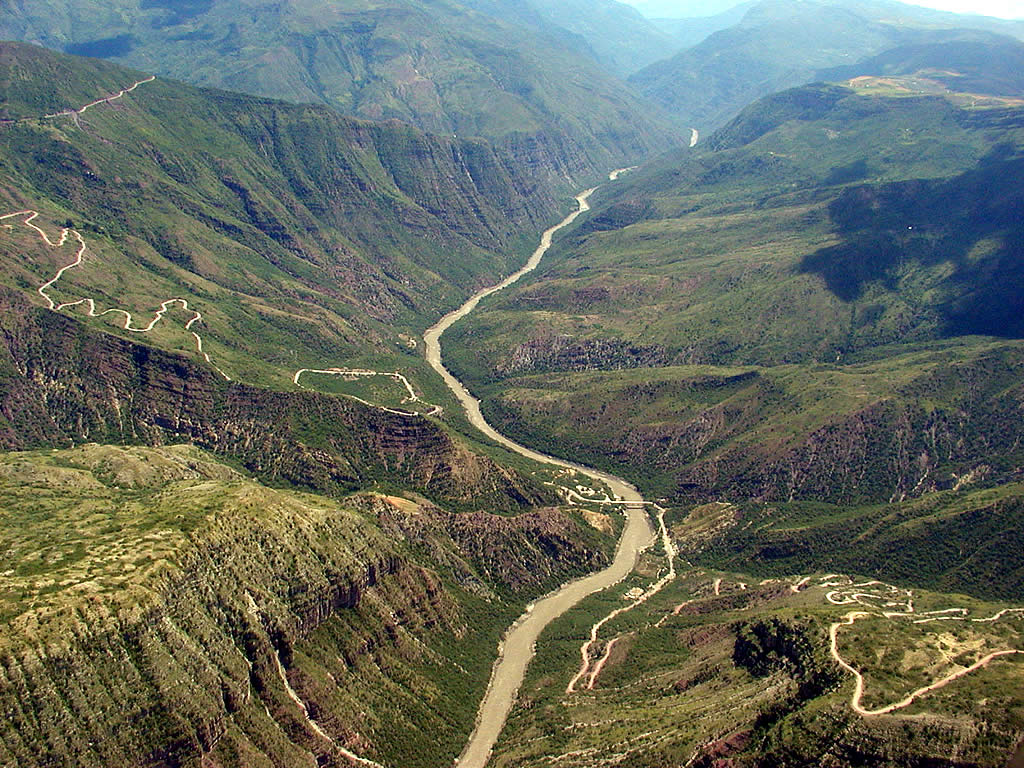
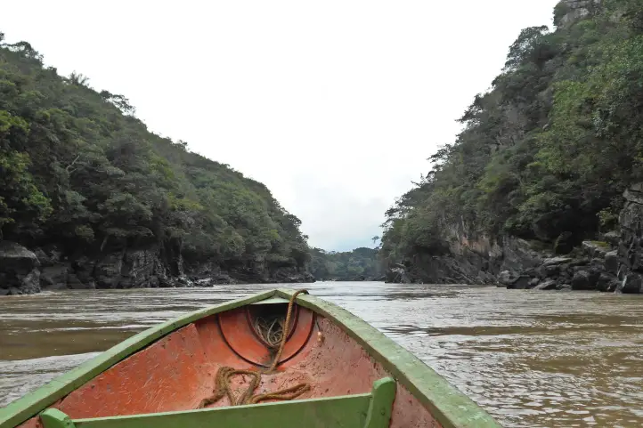
Located 1.3 km away from the center of town with a walk of approximately 22 minutes, at an altitude of 2,250 meters above sea level you will be able to appreciate a breathtaking view of the Cauca River canyon.
In this natural reserve is part of the group of families that offer the service of ecological tours where you can meet countless species of fauna and flora.
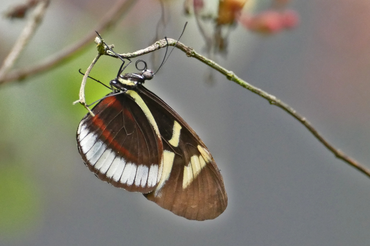
In the ecopark you will be able to see deer, butterflies, birds, howler monkeys, armadillos, bush dogs, among others. Also, in its more than 4,000 hectares you can find sarros, eucalyptus trees, seven-horned trees and a great variety of ferns.
Tour to La Nohelia
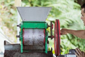
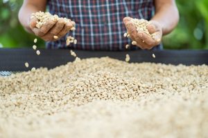
In the company of the guides of La Nohelia you will discover the coffee culture in a tour through a coffee farm. Where you will learn about the whole process of harvesting, washing, drying and roasting of special coffee for the world, and finally you will taste a cup of high quality coffee.
Too you will visit the roasted coffee processing plant where you will learn the process to highlight the attributes of coffee from various growers (coffee growers) of the municipalities of Jericho, PuebloRico and Tamesis.
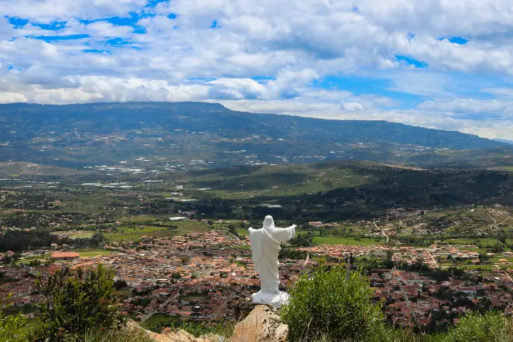
Cristo Redentor Viewpoint
It is a beautiful monument of white color that adorns the hill of ‘El Salvador’, it was inaugurated in October of 1828. The meaning of the locals is that his raised arms is the silent guardian that protects Jericho.
It was also erected as a protest and reparation, after the destruction of the Sacred Heart of Jesus, during the religious persecution in Mexico. It is a worthy expression of faith, hope and goodness.
To get to this point you only have to walk for 10 minutes from the center of town, from there you will have a beautiful panoramic view of the town.
Visit the Nuestra Señora de Las Mercedes Cathedral
This beautiful cathedral was built in brick and its most relevant feature is the height of its columns, it has an organ with 1,235 flutes, a crucifix made in 1880 and an oil painting of the Virgin of Las Mercedes, brought to the country in 1850. It is the main temple of the municipal diocese.
In addition you will be able to appreciate a giant poster of the Saint Laura Montoya, having clear that Jericho is the cradle of the believers of the first saint of Colombia.
Museum of Religious Art
This museum is in the lower part of the cathedral and inaugurated in 1976. It is a place that you will love because it houses and preserves representative elements.
Among the most valuable elements that you will see is a French censer from the end of the 19th century, which belonged to the old cathedral since 1893; A naveta, used to carry incense and the high places of worship, from the 20th century, of French origin; Vestments of Monsignor Francisco Cristóbal Toro and some purple bonetes, used by the bishops in the ceremonies.
You will learn much of the history of the town as the great religious history of Jerico, if you are a devout person it will be a magical experience.
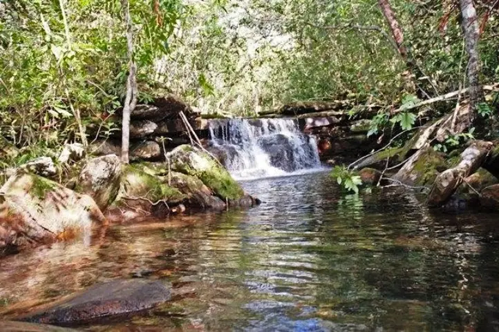
Los Balsos Botanical Garden
The garden includes a butterfly garden, a cactus garden, exhibition spaces, a library and a pond.
It is an ideal place to learn about the flora and fauna present in the town, besides to enjoying the tranquility of the garden.
What do to Around Jericó?
Visiting Támesis
A very beautiful town in the Cartama Valley in the southwestern region of Antioquia, approximately 3 hr from Medellín. It is a town surrounded by a spectacular nature that invites you to stop and enjoy the views of the beautiful landscape green and natural and old houses with typical facades of many colors.
Since Támesis is 25 km from Jericó you must take a 1-hour road trip. In Tamesis you can do adventure activities such as:
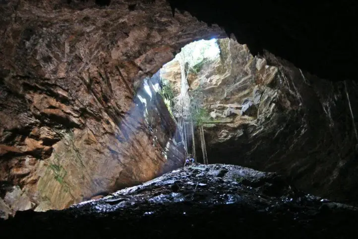
Caverns of the San Antonio River
The caverns of the San Antonio River, which have beautiful formations and crystal clear water sources at the bottom. You must keep in mind that to perform this activity you must have change of clothes.
Route of petroglyphs
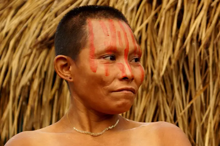
The route of petroglyphs is located inside an indigenous settlement of the Embera Chamí tribe. There you will be able to learn more about the indigenous culture and customs that are still preserved there.
Paragliding
You can do this activity to appreciate the beautiful landscapes in this sector of the department of Antioquia.
Tubing
You will be able to make a descent through the Rio Frio in a rubber tire to appreciate the beautiful scenery.
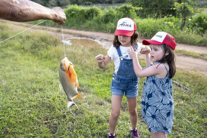
Sport fishing
Támesis has La Parcelita, a place where you can do sport fishing.
If you wish you can do several of these activities in one day and return to Jerico. Moreover, if instead you want to stay for a couple of days we recommend Acantos Country Hotel.
References
Colombia Travel
Network of Colombian Heritage Villages
About the author
Luisa Martin
Engineer, world traveler, amateur photographer, traveling blogger, and foody.
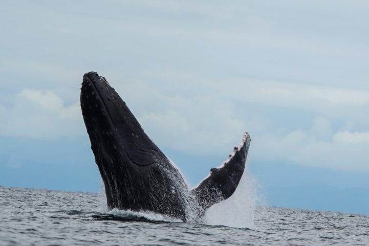
The answer is simple! If you like nature and also like to support community-based tourism activities, Uramba Bahía Málaga is a destination for you: It is a worldwide recognized biodiversity hotspot, you can see humpback whales there, and you will be helping an Afro-descendant community that bet on ecotourism as a new way for the development of its territory.
Uramba Bahía Málaga is the 56th National Natural Park declared in Colombia and is located in one of the most biodiverse places on the planet: the Biogeographic Choco, in the Pacific Region.
This wonderful and highly pristine place is considered a hot spot for nature conservation worldwide. The calm waters of Uramba Bahía Málaga National Natural Park are the preferred place for the birth and breeding of humpback whales, making this place even more special.
You can’t miss the chance to visit Bahia Malaga in Colombia. This 100% marine area contributes to increasing the representativeness of marine ecosystems in the National System of Protected Areas – SINAP- and also strengthens the socio-cultural dynamics of the afro communities living in the area through community-based ecotourism.
Discovering Uramba Bahía Málaga National Natural Park
This protected area is located in the Pacific Coastal Region in the southwest of Colombia. The park has an extension of approximately 479.94 km² of the marine surface.
The marine waters near Bahia Malaga are considered the migratory route of humpback whales, or yubartas, (Megaptera novaeangliae). This place of calm and deep waters is annually visited by more than 500 yubarta whales from Antarctica, that come to mate and raise their calves between the months of July to October.
The Socio-Cultural Importance in the Uramba Bahía Málaga Territory
Uramba Bahia Malaga is a name of African origin, which means Minga, or group. This name arose due to the particular way in which this protected area was created.
This National Natural Park born as a joint effort between the local communities that live there and the government, the latter through the National Park System. Additionally, the park is under the surveillance of the Colombian Navy.
The afro-community councils present in Bahia Malaga are:
Juanchaco,
Ladrilleros,
La Barra,
La Plata – Bahía Málaga, and
Puerto España – Miramar.
This important conservation unit seeks to conserve the marine and coastal ecosystems of Bahia Malaga and to strengthen the cultural dynamics and social organization for the management of the territory based on the knowledge and ancestral wisdom of the black communities that live there.
La Barra Beach, Ladrilleros, Colombia
Commercial Port or Natural Park?
But, despite the enormous natural and cultural wealth of the region, there was also the intention to turn this bay into a huge multifunctional commercial port.
Fortunately, the local community was convinced to apply alternative economic development options such as nature and cultural tourism; as well as their own conscious and responsible relationship with the territory, as their cultural practices have contributed substantially to the conservation of the area.
Thus, this reserve is the first in Colombia where community-based tourism plays a central role, and it is administered by the Afro-descendant community councils that exist in the region and the national park system. It is the first joint administration proposal in Colombia.
Thus, after much debate and argumentation from both sides, in August 2010, this area was officially declared as protected.
The communities settled in Bahía Málaga affirm that the area is not only important for its biodiversity but also for its cultural richness. Black communities and indigenous peoples present in the area have achieved an important degree of social organization in their ancestral relationship with the territory, and their cultural practices have contributed substantially to the conservation of their ecosystems. In this sense, declaring Malaga a protected area serves a dual environmental and sociocultural purpose.
Uramba Bahía Málaga Biodiversity
The Uramba Bahia Malaga Park is home to an immense diversity of continental and marine flora and fauna species and has been identified as one of the priority conservation sites in the Colombian Pacific.
The humpback whale (Megaptera novaeangliae)
The marine and coastal ecosystems of Bahía Málaga represent the Colombian Pacific and are a fundamental scenario for the reproduction and breeding of the Humpback Whale and the perpetuation of wild species of seabirds and shorebirds, sea turtles, estuarine and marine fish, and crustaceans.
The annual arrival of humpback whales is its main attraction. However, the beauty and diversity of the landscapes of Bahía Málaga and its area of influence are also ideal to enjoy nature.
The park has diverse ecosystems such as very humid tropical forests, beaches, cliffs, islands, estuaries, and bodies of water with soft and rocky seabeds.
How to get to Uramba Bahía Málaga National Natural Park
Uramba Bahía Málaga National Natural Park is in the middle portion of the Colombian Pacific coast, in the District of Buenaventura, in the department of Valle del Cauca. There are two options to access the Park from Bogota:
Bogota – Buenaventura
First you make a Bogota-Buenaventura trip by air, with 1h 15m duration. There are 2 flights per week with Satena airlines. Then you must make the transfer Buenaventura-Juanchaco by sea, which takes 1 hour and is done in a speedboat.
Bogota – Cali
Travel from Bogota to Cali by air or land. Once in Cali, you have to travel to Buenaventura by land. Finally, take the maritime route from Buenaventura to Juanchaco, which takes 1 hour and is done by speedboat.
What to do in Uramba Bahía Málaga National Natural Park
We recommend you plan your visit to stay for at least 3 days and 4 nights. Especially because of the long trip by road and then by boat. This is not a one-day stay destination.
Unfortunately, the visit to the Uramba Bahía Málaga National Natural Park has been suspended due to the health emergency that the country is facing because of covid-19.
Hiking, Canoeing, and Kayaking
Enjoying the beautiful Pacific landscape by doing hiking is a great experience. In the park’s area of influence, there are hiking and canoeing activities through the mangroves.
Although there are no defined aquatic trails in the bay area, it is suggested to follow the internal circuits to visit the route of the piangua, ostional, the waterfall of La Sierpe and Tres Marías in the sector of La Plata, Playa Chucheros, Juán de Dios, the beaches of La Barra sector, Juanchaco and Ladrilleros cliffs and their natural pools.
Kayaking through mangroves is highly recommended, also canoeing to Isla Plata, which is not the most exciting but still worth the try.
Birdwatching
Bird watching is a potential ecotourism activity in the park, but it is not well-developed. The park has a record of 107 species of birds, being an important point in the reproduction of marine birds.
Wildlife
Despite the huge marine and terrestrial diversity in the park, the main attraction is humpback whale watching. Thus, activities such as diving or snorkeling are not offered.
Humpback whale watching is an activity addressed by young natives from the local communities, who act as environmental interpreters.
During the whale season, the highest density of whales is between the months of September and October.
If you visit the Uramba Bahia Malaga park for a whale watching tour you should keep in mind that:
You will receive a 10-minute induction on the importance of the area and the significance of the role it plays in ecological processes such as reproduction, calving, breeding, nursing, socialization.
You must take a boat that carries a flag or a sighting authorization badge. The first trips leave at 8 am.
All boats must be accompanied by a community environmental interpreter.
The defined whale watching period is between July 15 and October 15.
Whale watching time for each group should be in the range of 15 to 30 minutes.
The approach to the whales should be slow, parallel, and always from behind.
The boat should maintain 200 meters from the individuals, so do not ask to get too close.
Avoid following the females with their calves.
You must be patient as only up to 5 small boats are allowed per group of whales. Also, you cannot be in a hurry, as the motors will always be neutral.
Where to stay in Uramba Bahía Málaga National Natural Park
The park does not offer accommodation, therefore our recommended options for you to stay are:
Lodging at La Barra Beach
Coco House Hotel; Casa Majagua and Vista al Mar Hotel.
Lodging at Ladrilleros Beach
Hotel Zully, Hotel Villa Cindy, and Hotel Reserva Agua Marina.
Best time to visit Uramba Bahía Málaga National Natural Park
The park can be visited all year round. The dry season starts at the beginning of June until late September and from the beginning of December until late February. In addition, whale season starts from July to October.
Uramba Bahía Málaga National Natural Park Entrance fees
Currently, no fees apply.
What to consider before visiting Uramba Bahía Málaga National Natural Park
To take any of the tours inside the park you must hire an authorized and certified guide.
Consider wearing personal protective items (sunscreen, sunglasses, towel, insect repellent, and hat).
We recommend the use of binoculars to admire animals’ behavior and beauty in their natural habitat.
Carry valid identity documents and health insurance.
Be vaccinated against yellow fever and tetanus.
If you take specific medications, take them with you in a personal first aid kit.
Some prohibitions
Feeding, bothering, or hunting animals, alcoholic drinks and drugs, littering, burning garbage, felling, and capturing wildlife.
References
Colparques
National Parks Systems
bahiamalaga.org
About the authors
Luisa Martin
Engineer, world traveler, amateur photographer, traveling blogger, and foody.
Sara Colmenares
The current director of Sula. Doctor in Biological Sciences. Her main interests are to explore and understand the organism-environment interactions, taking advantage of emerging knowledge for the management and conservation of species and ecosystem services. She is currently working as a consultant in functional ecology, ecosystem services, and conservation projects in Colombia related to ecotourism and birdwatching.
Discover the Natural Wonders of the Snow-capped Volcanoes of Santa Isabel and Tolima, both famous destinations for hiking in Colombia. Find here useful information for your hiking trip to these two beautiful mountains in the Central Andes of Colombia.
The Andean Mountain Range
A large part of Colombia belongs to the so-called Andean highlands, consisting of the three Andean ranges which spread across a vast part of the territory.
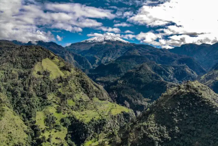
Los Nevados National Natural Park is in the middle of one of these ranges, in what is known as the “Cordillera Central” or Central Andes (the middle range), splitting its territory through 4 departments named Tolima, Caldas, Risaralda, and Quindío.
At Los Nevados National Natural Park you will enjoy 6 volcanoes: Ruiz, Tolima,Santa Isabel, Cisne, Quindío and Paramillode Santa Rosa.
Snow-capped Santa Isabel volcano
Santa Isabel volcano, also known as Poleka Kasue which translates “maiden of the mountain or princess of the snows”, was named after the ancient tribes of the area.
The Santa Isabel volcano is between the provinces of Risaralda, Tolima and Caldas, and sits in-between the other two snow-capped volcanoes: Ruiz and Tolima.
Santa Isabel is the lowest glaciated mountain in Colombia and one of the few equatorial glaciers in the world.
It consists of three main peaks:
The Northern one at 4,964 meters above sea level,
The Central one at 4,934 meters and
The Southern peak at over 5,100 meters above sea level.
Hiking to the summit of Santa Isabel
Considering its moderate altitude it is not necessary to have experience in climbing snowy mountains. But it is important to take a day or two on a farm nearby the hiking trail to the summit to get used to the lack of oxygen and the weather.
For a better experience, 2 days of travel is highly recommended.
Day 1: Bogotá-Manizales-Base camp (Santa Rosa de Cabal)
Take a 40-minute flight from Bogota to La Nubia (MZL) airport in the city of Manizales. From Manizales, you must take a 1-hour road trip (bus trip) to Santa Rosa de Cabal where you will stay on a local farm.
Taking the earliest 06:00 am flight is deemed very convenient and will allow you to reach your destination at approx. 10:00.
Enjoy some typical breakfast, take a rest and immediately after begin your journey to the entrance of Los Nevados National Natural Park.
Arrival at Los Nevados National Natural Park
Upon arrival, expect a quick “things to care about” chat with officials from the National Park.
Please note that the entrance fee for non-resident foreigners is COP 64.500 (approx. 18 USD), and it includes a tour guide and medical insurance.
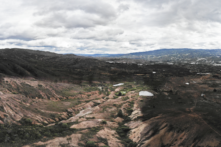
Otún Lagoon
The first stop, “Otún” Lagoon, located about 4,000 meters above sea level, will help you get an idea of the terrain and the conditions.
To get to Otún Lagoon first take a 3.5-kilometer hike to the base point where you will have a rest and some delicious lunch.
In the afternoon, the journey will resume heading to Otún Lagoon viewpoint for about 1 extra hour. Once there enjoy the view.
The return trip will commence before sunset all the way back to the farm.
Day 2: Base camp- Summit of Santa Isabel snow-capped volcano
The day starts at crazy early 1:30 a.m with some hot drinks and energy bars. A -transport will take you in 1 hour to the mountain rise at 4100 meters above sea level where your journey will begin.
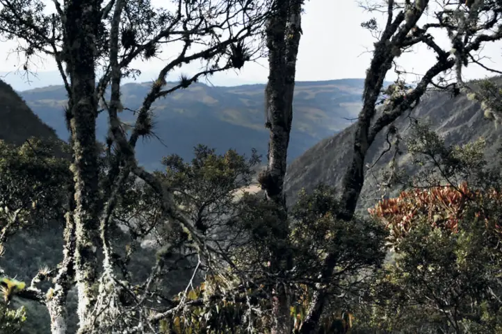
The trail from this point leads to the glacier known as Las Conejeras (4700 meters above sea level) with a walking time of 3 hours.
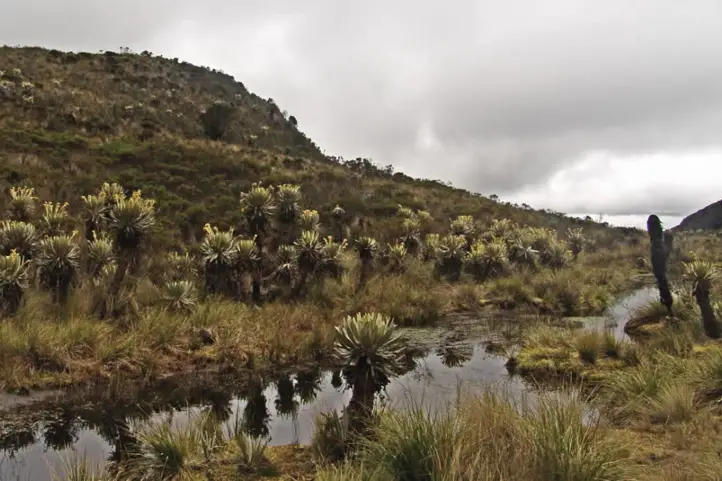
During the hike be sure to enjoy the large variety of plants, including, the famous Frailejones, Spanish for “Big Monks”. These are some of the most important paramo plants and essential for the preservation of this type of ecosystem.
Moreover, lagoons and a beautiful panoramic view of the Nevado del Ruiz Volcano are also worth enjoying.
From Las Conejeras onward mountain-climbing equipment will be used to reach the top of the snow-capped volcano of Santa Isabel. This 2-hour hike across snowy trails allows everyone to appreciate an unforgettable 4964 m above sea level panoramic view.
1 hour at the peak is more than enough to appreciate the view and get some well-deserved rest. After that, head down to the base camp.
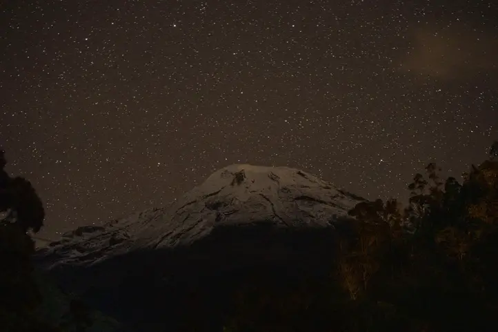
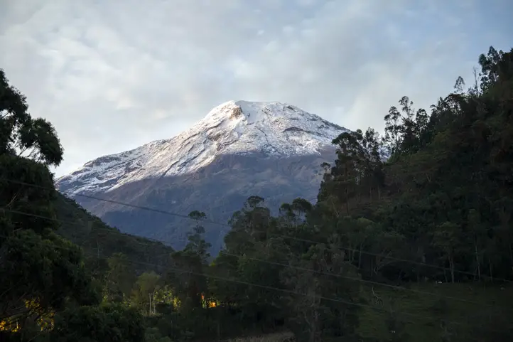
Snow-capped Tolima (Dulima) volcano
The Tolima Volcano is also known as Dulima which means “Emerged from the snows”, was named after the ancient local tribes inhabiting the area.
The natives considered that the spirit of the brave priestess and leader “cacica Dulima or Ibanasca” inhabits this snow-capped volcano.
Nevado del Tolima from the Ukuku Lodge.
The Tolima volcano is located in the province of Tolima, in the central mountain range of the Colombian Andes.
The Tolima snow-capped volcano is an attraction for those who wish to go beyond their limits due to its height (5,220 meters) and harsh climatic conditions. It has a glacier cap with an area of 2.8 km2 and a volume of 69 million cubic meters of ice.
Thus, those who wish to climb this snow-capped volcano must be experienced.
The Tolima Volcano is an important tourist attraction as a site for mountaineering and ice climbing, as well as for its thermal springs.
Hiking to the summit of Tolima
To visit the snow-capped volcano Tolima there are two routes, one of 4 days and the other of 3 days.
Option 1 (4 days)
Day 1: Bogotá-Armenia-Salento
Take a 1-hour flight from Bogota to El Eden International Airport (AXM) in the city of Armenia. From Armenia, you must travel by land to Salento for approximately 1 hour.
Once in Salento you can enjoy the rest of the day and visit famous sightseeing spots and the handicraft market of the town.
Day 2: Salento- Refuge
After breakfast in Salento, it is necessary to take a 30-minute “jeep” ride to the famous Cocora Valley. Next, start your hiking journey with an initial 4.5-kilometer hike crossing 6 rustic bridges.
The first stop is at 3100 meters above sea level refugee, from where it is possible to have lunch.
During this part, one can enjoy the flora and fauna of the Colombian Andean forests. Watch out especially for Andean tapirs, spectacled bears, pumas, sloths, Yellow-eared parrots, blue toucans, Andean guans, and Andean condors, among others.
The second 9 km hike starts after lunch through the middle of the unique ecosystem in the Andes mountain range: “the páramo”. The páramo is the ecosystem of the regions above the continuous forest line, yet below the permanent snowline.
Enjoy the large variety of plants, including, the famous Frailejones “Spanish for Big Monks”. One of the most important paramos plants, essential for the preservation of this type of ecosystem and considered an endemic species.
This hike ends at 3700 meters above sea level refugee site, where camp will be set up, and dinner and hot drinks served. Rest is highly recommended.
Day 3: Refuge- Base Camp
Revitalize yourself, enjoy breakfast, drink your coffee and get ready for a 9km mountain top hike, starting at the valley of the snow-capped mountain.
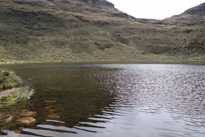
One hour away from the Refuge camp, you will first come across the beautiful Laguna del Encanto, 4,000 meters above sea-level wetland that gives rise to the Totare River that is on the way towards the Base where camping will be set up.
This 4,350 meters above sea level Base Camp is hit strongly by snowy winds that favor the view of the three additional beautiful snowy volcanoes, to wit: Nevado del Ruiz, Nevado Santa Isabel, and paramillo del Quindio.
At the Base Camp, additional preparation talk and rehearsal on the use of necessary mountain equipment will be given by the guides, in preparation for the next day’s hike to the top.
Please note that the entrance fee to Los Nevados Park is for non-resident foreigners is worth COP 64.500 (approx.18 USD), and includes guide and medical insurance.
Day 4: Base camp- Summit of Tolima snow-capped volcano
The final day starts at 1:30 a.m. with some hot drinks and energy bars.
Bear in mind to reach the top of the snow-capped volcano you must cross 3 different zones during a 9 kilometers hike:
Arenales/morrenas (4,350 m-4,750 m): it has a steep slope and most of the way the terrain is sandy, its duration is 1 hour of walking.
Rock zone/old Glacier (4,750 m-4,950 m): a 1-hour walk through rocks once covered by ice and now uncovered by the melted glacier. Note that the use of personal protection equipment (helmet, harness, and rope) is important for safety.
Glacier/top (4,950 m-5,220 m): the last part of the scaling takes about 1.5 hours., temperature significantly drops, and difficulty in breathing might be experienced.
At the top, it’s good to relax, recover, enjoy the scenery before returning to the Base Camp for lunch.
The last part of the return trip down the mountain is riding a donkey back which helps speed up the journey.
Nevado del Tolima from the Combeyma Canyon at night
Option 2 (3 days)
Day 1: Bogotá-Ibagué
Take 45 minutes flight from Bogota to Perales Airport (IBE) in the city of Ibagué where you can spend your afternoon and night going around the city.
Day 2: Ibagué-Base Camp
Early in the morning, a Jeep will take you to El Silencio at 2550 meters above sea level. From there, take a 1-hour hike to the thermal springs El Rancho and enjoy breakfast.
Next, you will face the steep hiking of Las Raices, known for its humidity and very dense flora.
The most representative flora visible on this route apart from the Espeletia hartwegiana, so-called Big Monks (frailejones) are the following species:
The Loricaria colombiana, endemic plant of Colombia in the pussy’s-toes tribe within the sunflower family.
The Polylepis sericea, another endemic of highlands.
St. John’s wort of the genus Hypericum
And the paramo rosemary of the genus Diplostephium.
Continue through the sector of Lajas until reaching Tierra de Gigantes. It is worth noting this is the last stop to refill drinking water.
Reaching 3700 meters above sea level you will come across La Cueva where you can enjoy a rest and have lunch.
The last part before reaching the 4,200 meters above sea level Base Camp is a moderately inclined hike of 2 hours. There you can camp and rest until the early hours of the morning.
Day 3: Base camp- Summit of Tolima snow-capped volcano
The day starts at 1:30 a.m. with some hot drinks and energy bars. Walkthrough las Latas until you glimpse the first snow-covered areas.
From this point on, it is necessary to use the personal protective elements (hull, harness, and rope) to make the last ascent to the top of the snowfall for approximately 45 minutes.
Lastly, go back down to the camp and get some well-deserved rest.
By taking these hikes you support sustainable tourism
During any of the hiking options you can support the following ventures:
Energy bars @boli. bar. co, an enterprise of natural, tasty, and nutritious snacks, free of excess sugar.
El Chalet del Cisne, eco-hotel has a panoramic view of the snow-capped peaks of Ruiz and Santa Isabel.
The restaurants that you will find at each of the obligatory stops, each of the dishes served there are prepared by the inhabitants of the area.
Recommendations before hiking the snow-capped volcanoes of Santa Isabel and Tolima
Enter only the authorized trails by Parques Nacionales, which are well kept, safe, and have guide services.
Bring along convenient clothing since temperatures can significantly drop.
Carry a suitcase of at least 30 liters, with a waterproof jacket and waist straps.
Bring along basic protective elements such as cap, neck protector, flashlight, sunscreen, UV filter glasses, gloves, and boots with a high or medium cane.
The entry and use of single-use plastics is prohibited by Sistema de Parques Nacionales Naturales.
Carry enough snacks for the tour and make sure to store wraps in the available suitcase.
Do not litter and help preserve the ecosystem
Liquor or any toxic, psychoactive, or hallucinogenic substances are not allowed within the premises of the Parque Nacionales.
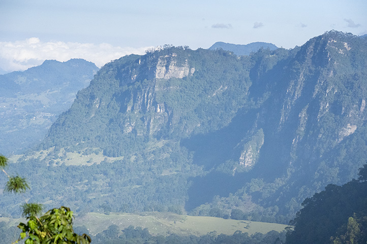
Chicaque Natural Park is a natural reserve located only 30 minutes from Bogotá, Colombia. It is a must-see hiking destination near Bogota that can be easily visited in one day. You can also spend several days in Chicaque if you have time.
The park has a magnificent area of well-preserved cloud forest of the eastern Andes. It offers an incomparable landscape, perfect for hikers and nature lovers.
Chicaque Park – Landscape from the Viewpoint
Hiking, horseback riding, bird watching, camping, and some adventure sports, are some of the activities you can enjoy there.
It is a perfect place to visit with kids or family. The park has several lodging options. You can stay at the hotel, or cabins, or the tree houses. It also offer services of glamping, two camping areas, and restaurant service.
Hiking in Chicaque Park
In Chicaque you will find more than 20 kilometers of ecological trails of different levels of difficulty. These 20 km distribute in 7 trails. Below I will tell you about each trail.
The Eagle’s Peak Trail
The Eagle’s Peak is a natural viewpoint. I has an elevation of 2,290 meters above sea level, on the edge of the Andean Eastern Cordillera.
It is a formation created by a series of rocky detachments of the Peña. From there, you will have an incredible panoramic view of the Tequendama region and the Peñas Blancas mountain range.
You are able to see the towns Santandercito, Mesitas, Anapoima, La Mesa, and Tena. On clear days you can also see the snow-capped mountains of Tolima, Santa Isabel and Ruiz, in the Central Cordillera.
There are high concentrations of carbon in the soils and rocks, for this reason, the rocks are black. Around the peak, air currents formed by the strong temperature changes attracts large birds such as vultures and eagles.
Level of physical demand: Medium
Length of the route: Varies according to the chosen path.
Travel time: Varies according to the chosen path.
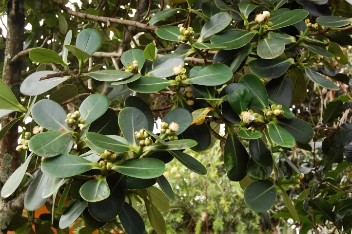
El Roquedal Trail
The Roquedal trail is an extension of the trail to the Eagle’s Peak.
Roquedal trail goes through a rocky area with vegetation and formations similar to the Eagle Peak trail. On this trail, you will find vegetation plenty of orchid species and Gaques (Clusia multiflora).
Gaque (Clusia multiflora)
The Gaques are trees with thick, oval leaves that produce a yellow resin. These trees attract different birds species, due to their attractive and nutritious flowers and fruits.
Sparkling violetear at Chicaque Park
You can find birds such as: Hummingbirds (Trochilidae), Glossy flowerpiercer (Diglossa lafresnayii), Black Flowerpiercer (Diglossa humeralis), Masked Flowerpiercer (Diglossa cyanea), White-sided Flowerpicker (Diglossa albilatera), Plate-billed Mountain-Toucan (Andigena laminirostris), among others.
Level of physical demand: Strong
Length from Eagle’s Peak: 667 meters (667 yards)
Approximate travel time: 25 minutes.
Butterflies trail (Mariposas)
It begins near the Eagle’s Peak, just below La Granja. It runs through the south-western part of Chicaque Park. This trail is notorious for its steep slopes and lush vegetation.
On the trail it is possible to see the beautiful butterflies known as “Alas de Cristal” (Crystal Wings).
Level of physical demand: Strong
Length of the route: 1.6 kms.
Approximate travel time: 1 hour
Attention: This is the longest route to the Refugio.
Matoño Lagoon Trail
The Matoño Lagoon honors the founder of Chicaque “Manuel Antonio Escobar Lozano”. It is a small body of water fed by spring waters that flow from the lower part of the Eagle’s Peak.
For more than 40 years the lagoon suffered from severe degradation. In 2012, Chicaque acquired the property next to the lagoon. Since then, the natural reserve started the lagoon’s restoration.
Today the lagoon has recovered part of its water mirror, and is visited by birds, and inhabited by small frogs and crabs.
Some wax palm trees grow around the lagoon. Manuel Lozano, the precursor of conservation in Chicaque, planted them more than 120 years ago.
The trail has steep and rocky sections that can be slippery in rainy seasons, so it can be very demanding.
Level of physical demand: Medium/High
Aproximate travel time: From the refuge 2.5 hours, from the eagle’s peak 1.5 hours.
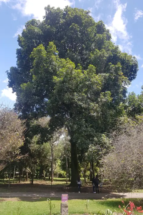
Colombian Oak Forest Trail
This is perhaps one of the last oak forests near Bogotá. It is a population of oaks of the species Quercus humboldtii, the colombian oak. This tree is endemic to Colombia and is critically endangered due to habitat loss and timber extraction.
Colombian Oak – Quercus humboldtii
The strength of the oak wood makes it a very desirable tree, it was used in the construction of railroads. These trees can live up to 300 years and can reach up to 30 meters in height.
It is an important tree in the Andean forests. It allows the location of epiphytic plants such as orchids and bromeliads, as well as lichens.
Its flowers are visited by bees (Apis mellifera) and its acorns are food for many mammals of the Andean forest.
Species such as the collared peccary (Pecari tajacu), the white-tailed deer (Odocoileus virginianus), the red-tailed squirrel (Sciurus granatensis), the mountain paca (Agouti taczanowskii), the Central American agouti (Dasyprocta punctata), and the pacarana (Dinomys branickii) benefit from it.
Zip-line and Canopy
In the Bosque de Robles trail you will find a zip line activity on an incredible 340-meter-long zip line where you will reach speeds of up to 50 kilometers per hour.
You can also enjoy a canopy activity on a 25-meter (82-foot) tree platform. You can climb it on a rope or a ladder. Once at the top, you will enjoy a extraordinary view.
Level of physical demand: Moderate
Length of the route: Approximately 2.5 kms.
Approximate travel time: 1 hour, starting from the Refuge.
Waterfall Trail
On the trail that leads to the waterfall, you will see two ravines: Chicaque and Velez. This trail has traces past water streams.
This trail was designed to highlight the importance and value of water, which is becoming scarcer every day. This becomes evident when you reach the waterfall.
This waterfall has a drop of approximately 70 meters high, but its flow is very reduced. This is due to a eucalyptus forest that inhabits the upper part of the mountain, outside the park’s boundaries.
Negative Effect of Introduced Species
Eucalyptus trees are foreign species that were irresponsibly introduced into the mountains of the eastern cordillera. They are a living example of the negative effect of introducing foreign species to native ecosystems.
Eucalyptus trees are plants that consume a lot of water, drying the soils and excluding the development of native species of the Andean cloud forests, which are highly dependent on humidity and water.
This is reflected not only in the loss of habitat for native plants, but also for the local fauna, which have to move to other places, since the eucalyptus does not provide shelter or food, as does a Colombian oak or a Gaque.
The stone walls of the waterfall have a high concentration of iron, which gives it a reddish color that contrasts with the intense green of the mosses.
For environmental and safety reasons, visitors are not allowed to bathe in the waterfall.
Level of physical demand: Hard
Length of the route: 3.5 kms
Approximate travel time: 2 hours, starting from the Refugio.
The Colonial Trail
Before colonization, this was a pre-Columbian trail used by the Muisca and Panches Indians. It was used to link the savannah of Bogotá (the land of the Minga) with the Magdalena valley. Later, the Spaniards widened the trail to allow the passage of horses and mules.
The road is built entirely of stone steps. These steps are polished by the passage of dozens of generations over hundreds of years. The colonial trail retains a centuries-old air and is now part of the cloud forest. To walk along it is to return to a distant and peaceful past.
This trail is fragmented into two parts and connects the upper part of Chicaque with the lower part. It begins near the entrance of the park where the steps of the main viewpoint end, and ends near La Playa creek, just 500 meters from the Refuge. It is the shortest route between the entrance and the refuge.
Level of physical demand: Downhill, medium. Climbing, high.
Length of the route: 1.5 kms.
Approximate travel time: 40 minutes.
Where is it located?
It is located on kilometer 8 of the La Mesa – Soacha highway. Then you have to take the road Cascajal – Parque Chicaque until kilometer 3.
Once there, you will find the parking lot, a restaurant and the park’s ticket office. After a short walk from the entrance, you will find with a spectacular viewpoint.
Sometimes the viewpoint gets cloudy, and you get the feeling of being above the clouds.
Recommedations Before Visiting Chicaque Park
We recommend wearing shoes with grippy soles and ankle protection.
Bring raincoat, hat, suscreen and insect repelent.
There is an electric jeep service that takes you from the refuge to the exit. Or, if you prefer, you can return on horseback.
If you suffer from cardiac or respiratory deficiencies, it is preferable that you do not go on long rides.
Note that the Park is not responsible for any type of injury or accident you may suffer.
The money paid for any service taken in the Park is not refundable.
Fees
The entrance fee to the park is around 10USD. Lodging has other rates, depending on where you want to stay: hotel, cabins, house tree, glamping or camping.
If you want to plan your trip to Colombia do not hesitate to contact us, visit our Plan your trip page!
Current director of Sula. Doctor in Biological Sciences. Her main interests are to explore and understand the organism – environment interactions, taking advantage of emerging knowledge for the management and conservation of species and ecosystem services. She is currently working as a consultant in functional ecology, ecosystem services and conservation projects in Colombia related to ecotourism and birdwatching.
Tolima is a department in Colombia where music is its distinctive expression… until now. In recent times, nature tourism has drawn the attention as a new attraction.
Birdwatching and nature tourism are new there, and emerged after the signing of the peace process. With it, people began to see bird watching and nature tourism as an economic opportunity.
Where is Tolima?
Tolima is located in the center-west of Colombia, in the Andean region. Its capital city is Ibagué, and it locates on the eastern flank of the Central Andes, in the center of the department. It is known as the Musical Capital of Colombia.
Tolima department borders to the north with Caldas, to the east with Cundinamarca, to the south with Huila and to the west with Valle del Cauca, Quindío and Risaralda departments.
So, if you are in the coffee region, or in Bogota or Cali, it will be very easy for you to visit this region by car, or by plane.
Perales National Airport is located in the east of the city of Ibagué and is the main airport in Tolima. It is in the process of becoming an international airport.
Rare food alert: One of the most famous meals in Colombia is the lechona. The lechona borned in Tolima. This is a dish based on pork meat, stuffed with peas and rice, and mixed inside the pork itself.
Lechona dish served in a Bijao leaf, with lemon and arepa.
It is baked in the oven, leaving the pork skin browned and toasted. It is served with a portion of the skin, in a Bijao leaf, previously passed through the fire, as a plate. This leaf is similar to the banana leaf, but it is not edible.
What does it mean Tolima?
The are several stories about the name Tolima. One of them tells that the word comes from the Panche term tolima, tulima or dulima, which means river of snow or cloud.
Another story refers to an indigenous woman called Tulima, or Yulima. Yulima was an indigenous queen and priestess who protected a religious sanctuary. This place was very rich in gold deposits, near Machín Volcano and Nevado del Tolima.
The Spaniards assaulted her and took her as a prisoner. They led her in chains to Ibagué, in whose main square the conquerors burned her alive.
While she was dying she received blessings from Father Cobos to help her soul elevates to heaven. The department preserved her legendary name as a perennial tribute to her martyrdom.
Tolima as a Nature Destination
Tolima covers an area of 149,800 hectares. It extends from the upper Magdalena valley in the east to the Tolima snow-capped mountain in the northwest.
Thus, the department of Tolima has a huge variety of ecosystems and life zones. There you will find tropical dry forests at 2800 meters above sea level, to the paramo life zone, at approximately 5280 meters above sea level.
Machín Volcano, Toche, Tolima, COlombia
This broad altitudinal variation arises into a great variety of climates and topographic aspects. This variation, in turn, results in a high number of habitats for a wide diversity of species, birds among them.
Additionally, the mountainous landscapes of Tolima makes it a very good region to visit for hiking.
Los Nevados Natural National Park in Tolima.
Also, the Magdalena River, the most important river of Colombia, crosses Tolima from south to north enriching the landscape. The city of Honda was one of its main ports in the colonial past (watch the video below).
The natural wealth of Tolima has allowed the development of several important tourist activities. Furthermore, several national natural parks belong to the department of Tolima and are reserves of water, flora and fauna: Los Nevados National Natural Park, Las Hermosas National Natural Park, and Nevado del Huila National Natural Park.
Aquatic Tourism
There are several aquatic parks in the lowland areas of Tolima you can visit with your family. Also, you can do rafting on the Sumapaz river in Melgar, Carmen de Apicalá, Coello, Flandes and Suárez.
In the north, at Mariquita, Honda, Ambalema and Falan towns, you can combine historical colonial tourism with water parks.
Sport Fishing and Water Sports
To the south is the Prado reservoir focused on sport fishing and water sports. This region also has a lot of indigenous history. There you will find Amerindian expressions in ceramics made by the Pijao communities.
Prado reservoir, Tolima, Colombia
The area also has incredible landscapes such as the Pacandé Mountain and the northern side of the Tatacoa Desert.
Hiking and Trekking
In the center of the department, Ibagué, Murillo and Líbano towns are close to Los Nevados National Park. There, mountaineering is the main attraction.
More and more people is discovering the biodiversity of birdlife in Tolima. Today, Tolima is 14 in the eBird’ species list of departments of Colombia, with 809 bird species reported.
Besides this, it is 8th in the Top 10 departments with more checklists, with around 14300.
In Tolima, a Bird Festival is also held every year. The most recent version was in 2019, being the fifth one. This festival features cultural and academic activities, as well as bird watching tours.
Tolima Birdwatching Routes
Private and public entities work together to protect and conserve the birds biodiversity of Tolima. Thus, since 2018, the Chamber of Commerce, the Ornithological Association Anthocephala, and Cortolima developed a total of 33 birdwatching routes in Tolima.
13 of these birding routes are near to Ibagué and the Río Viejo wetland in San Luis.
The main routes established in Tolima include:
Toche Canyon,
Combeima Canyon,
The northern route (Honda, Mariquita, Fresno and Falán),
Las Hermosas in Chaparral,
San Antonio,
Planadas,
Galilea forest,
Murillo – Armero route,
Roncesvalles,
Falán – Mariquita,
Clarita Botero en Ibagué
“Raúl Echeverry” Botanical Garden in Líbano, and
San Jorge Botanical Garden, among others.
One of the most important routes that you should not miss is the Toche Canyon Route. The Toche Canyon locates between the cities of Cajamarca and Ibagué.
Wax Palm at Toche, Tolima
There there are ten species of parrots, among them the Indigo-winged Parrot, the Yellow-eared Parrot and the Golden-plumed Parakeet. These species live in the ecosystem offered by the most conserved forest of wax palm in the country.
Top Birds of Tolima
Here’s a taste of what’s to come in a future post. The most representative bird species in Tolima are:
Current director of Sula. Doctor in Biological Sciences. Her main interests are to explore and understand the organism – environment interactions, taking advantage of emerging knowledge for the management and conservation of species and ecosystem services. She is currently working as a consultant in functional ecology, ecosystem services and conservation projects in Colombia related to ecotourism and birdwatching.
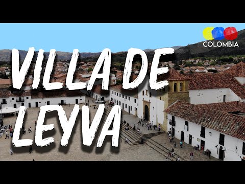
Villa de Leyva is a beautiful colonial town. It is part of the “Network of Colombian Heritage Villages”, located in the province of Ricaurte in the department of Boyacá.
Moreover, the town was founded in 1572 under the name of Villa de Santa María de Leyva and later recognized as a national monument in 1954 because of the beauty of its colonial architecture.
It is located 40 km west of Tunja, capital of the department, and 165 km from Bogota, capital of the country.
This town is very famous for its historical importance and its magnificent square. In fact, the Plaza Mayor of Villa de Leyva is the largest in Colombia and one of the most imposing in South America with its 14 thousand square meters.
The Diversity of Nature in Villa de Leyva
In addition to its colonial architecture, Villa de Leyva is characterized by its varied rural landscapes, and ecosystem ranging from paramo to desert. Also, the town is framed by two branches of the eastern mountain range of the Andes.
Due to its great offer, Villa de Leyva is ideal to encounter history, science, art, culture, and nature. It also has an important value in terms of paleontology, anthropology and archeology.
This park belongs to the National Natural Park System, created by Agreement No. 33 of 1977. It is located between the municipalities of Villa de Leyva, Arcabuco, and Chíquiza.
The park has an area of 6,750 hectares, and it is associated with the Pómeca River basin to the north and the Hoya del Río Chíquiza to the south. Additionally, the sanctuary has eight lagoons formed in the cloudy páramo. There you can see deer, weasels, and three species of woodpeckers, among other animals.
The entrance to Iguaque Park is through the road that leads from Villa de Leyva to Arcabuco. The Sanctuary is open to the public for ecotourism and it offers three cabins located in the sectors “Carrizal”, “Chaina” and San Pedro de Iguaque.
Important recommendations
To visit the Iguaque Sanctuary, it is necessary to bring adequate clothing for cold weather and moorland.
Also to bring garbage bags, a backpack instead of a suitcase, food that provides enough calories and beverages.
If you are going to camp, bring complete camping equipment, sleeping bag and sleeping bag.
People who suffer from hypertension, hypotension or mountain sickness should be cautious because the hike requires great physical effort.
The Mythic Iguaque Lagoon
Also called San Pedro Lagoon. It belongs to the Sanctuary of Fauna and Flora, has an area of 850 square meters, and is located at an altitude of 3,800 meters above sea level.
According to Muisca mythology, the Iguaque Lagoon is the cradle of humanity because the mother of that civilization emerged from its waters. From this lagoon emerged Bachué, mother of the Muiscas.
This is why this place is considered a sanctuary and a mythical place full of legends.
The Hidden Valley (Valle Escondido)
It is located at 2050 meters above sea level in the Salto and La Lavandera trail in the Las Vegas sector. The access to Valle Escondido is by an unpaved road that is in good condition, half an hour from the town center.
This beautiful valley is found by turning right by the Hacienda El Cárcamo. Among the attractions offered in addition to the lush landscape is the old Primavera Mill.
Pozo de la Vieja (Well of La Vieja)
It is located in Vereda El Roble, 6 km from the town of Villa de Leyva via Gachantivá through Alto de los Migueles. Its waters come from the Caño River.
This site is located on the road that goes to the municipality of Santa Sofia, approximately 20 kilometers from Villa de Leyva. It is a natural cave formed by a subway river.
It is a place you can visit to practice speleology. This cave is not very humid, so there are few stalactites and bats are their permanent companions.
El Hayal Waterfall
This waterfall is located on the road that goes from the municipality of Santa Sofia to the municipality of Moniquirá, approximately 6 kilometers away from Villa de Leyva.
It is a natural rock formation with a gigantic grotto of approximately 150 meters high. There you will find waterfalls of 25 meters.
The “Hoyo de La Romera” is located on the road that goes from the municipality of Santa Sofía to Moniquirá.
The hole is of great magnitude, with a drop of approximately 40 meters. There is speculation that this hole may have been used by the indigenous people to go to other towns.
People say that after 12 meters of ascent, there is a small cave. This cave is presumed to be the beginning of a road that leads to the municipality of Monguí (Boyacá), located almost 150 kilometers away.
It is also known as “El Hoyo de Los Infieles”. Legend has it that it was a place of punishment for women who were unfaithful to their husbands. They were thrown from the edge of the hole. It can be said that its original name was “El Hoyo de las Rameras” (The Hookers’ Hole).
The Blue Wells (Pozos Azules)
It is located 3 km from Villa de Leyva to Santa Sofia. You can go by car, horseback, bicycle or walking (30 minutes).
Pozos Azules are artificial wells that have taken this color by the action of salts and minerals in the soil.
Viewpoints
You will find beautiful viewpoints from which you can observe the breathtaking scenery of this territory, some of these are:
Colina el Santo Viewpoint
Located at 2,400 meters above sea level, to the northeast of the urban center, a 45-minute walk along a road with little demarcation.
From there, you can see the urban center of Villa de Leyva and the imposing mountains of its surroundings.
Colina del Santo Viewpoint, Villa de Leyva, Colombia
Alto de las Cometas
From this viewpoint, you can see the entire urban center immersed in the contrasting landscape of the lowlands and the mountainous area. It is located in the desert area, one kilometer from the village on the road to “Fósil”.
Alto de los Migueles
It is located approximately 5 km from the urban center, taking the road that leaves the cemetery of Villa de Leyva. From this viewpoint, you can see to the east where the landscape changes abruptly.
Cerro de Leyva
On this hill, there is a high Andean forest remnant where you can find foxes, rabbits, beacons, birds, and deer.
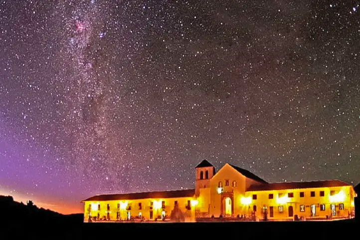
Stargazing
Astronomical Observatory
The observatory is an ideal place to observe the sky, the depths of the universe, to enjoy spectacular nights, to recognize constellations, to observe planets, nebulae, galaxies, shooting stars, to follow diverse phenomena and to marvel at mythical stories about the cosmos!
Night at Villa de Leyva – Facetas Boyacá
It has several telescopes and devices for the observation of the celestial vault. You will be able to explore the deep sky and also to observe sunspots and solar flares.
Besides this, there is also a space museum called Kosmos, ideal for visiting with your kids and family. The museum specializes in archeoastronomy, exobiology, history of flight, and space travel.
Finally, the museum also has a collection of meteorites unique in Colombia, and a planetarium ideal for projections.
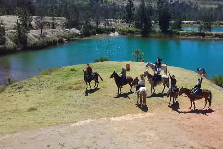
Without a doubt, getting to know Villa de Leyva is an adventure that you can make the most of through these horseback tours.
The ride consists of crossing the desert of La Candelaria towards the valley of Villa de Leyva. You will leave from La Candelaria Monastery, in the middle of the desert.
Finally, once you arrive in the town, you will be able to make a walk city tour and visit its main colonial attractions:
The Main Square of the town, considered the largest in Colombia.
The Casa del Cabildo, a historical relic near the main square.
The Casa de Nariño, a museum dedicated to preserving historical material from the colonial era.
The Cloister of San Agustin, the first church of the town.
I hope you liked this brief guide of natural destinations in Villa de Leyva. If you want to know more, or schedule your trip, do not hesitate to contact us.
Current director of Sula. Doctor in Biological Sciences. Her main interests are to explore and understand the organism – environment interactions, taking advantage of emerging knowledge for the management and conservation of species and ecosystem services. She is currently working as a consultant in functional ecology, ecosystem services and conservation projects in Colombia related to ecotourism and birdwatching.
Traveling with kids can be challenging. First of all, you are concerned about their safety. Second, you don’t want them to get bored. Experiences in nature are among the best to ensure fun, learning, and building great and beautiful memories.
Nature offers activities that can strengthen the bonds with your kids, and also provide them with impressions they will carry with them forever.
Colombia has many offers of this type. However in this post I will tell you about the safest and most enjoyable nature experiences in Colombia for your kids (from 4 to 18 y/o)
The Coffee Triangle for Kids
The coffee triangle is a major destination in Colombia, despite its size, there is a great diversity of thermal floors and landscapes. For this reason, three of our recommended destinations are found there.
In addition, this is one of the safest regions in Colombia and with the friendliest people.
1. Hacienda Venecia Coffee Farm in Caldas
The department of Caldas is a coffee destination par excellence. There you can go with your kids and learn about the process of coffee production and also about cocoa, i.e. chocolate!
There are farms like Hacienda Venecia, which have different types of accommodations, several experience tours, different walking trails, and a swimming pool!
What to do?
It is a very safe place, and you will be able to take tours on foot, by bicycle, visit the plantations, get to know the most beautiful birds and butterflies of the coffee region, and enjoy with your kids the coffee landscape.
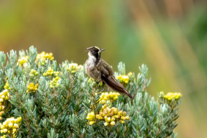
You can visit Los Nevados Park towards the Brisas sector, where there is a special platform for bird watching. From there it is possible to watch the Buffy Helmetcrest, and endemic hummingbird of Colombia.
On the way down from there you will find the Hotel Termales del Ruiz. The gardens of this hotel offer a a fun activity that consists of feeding hummingbirds from the palm of your hand.
The sensation of feeling one of these birds landing on your fingers is a beautiful, touching and unique experience that your kids will always remember! If you want to know more about hummingbirds I recommend you to read our entry 17 Unique Hummingbirds of Colombia and Where to Find Them.
Finally, spend a day in places surrounded by plenty of wildlife and nature such as:
Hacienda El Bosque, where you will visit a dairy farm and have the chance to see and learn about the high mountain birds; and,
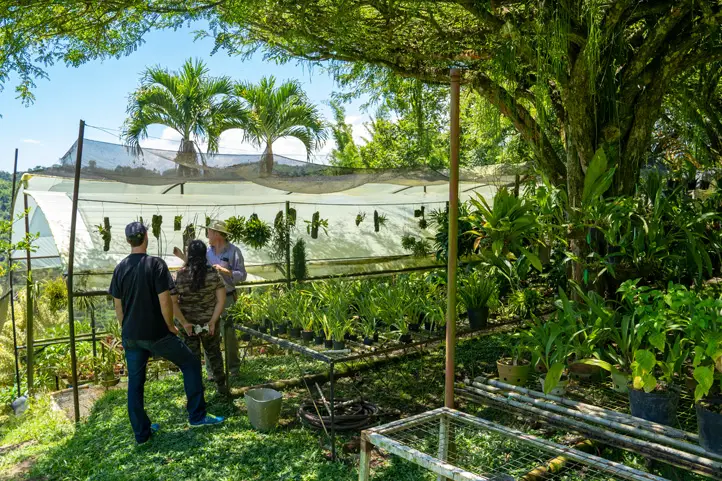
Finca Romelia, a place where you can visit an immense collection of orchids and bonsai.
Finca Romelia Colors of Life
2. Botanical Garden, Panaca Park and the Wax Palm in Salento in Quindío
Quindío is a department where you can have a lot of fun with your kids! You can stay in the city of Armenia, where there are many country hotels with swimming pools. I recommend you the Hotel Sazagua.
Quindío Botanical Garden
From your hotel in Armenia, you can make a day visit to the Botanical Garden of Quindío.
This Botanical Garden holds the most complete and beautiful collections of palms, heliconia, and butterflies of Colombia.
Heliconius heliconius at Botanical Garden of Quindio
Panaca Park
Afterward, you can dedicate another day to visit the Panaca Park. If you prefer, you can stay in this park for several days at the Hotel Decameron that is inside it.
Panaca is a park dedicated to country life. There your kids will be able to have interactive experiences with farm animals, attend fun animal shows, go on carriage rides around the farm, and participate in adventure activities such as canopying or crossing tibetan bridges, among others!
The Cocora Valley in Salento
Finally, you can go to Salento and get to know one of the most emblematic landscapes of Colombia: the wax palm fields of Quindío!
3. Ukumari Park, the Hot Springs in Santa Rosa, and Otún Quimbaya Sanctuary in Risaralda
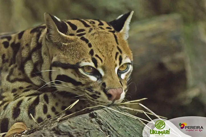
Leaving Manizales or Armenia, you can continue to the city of Pereira, and visit one of the most beautiful and oldest zoos in Colombia, the Ukumari bio park.
There your kids will be able to meet the most representative animals of the Colombian Andean forests, such as the Jaguarundi, the Chachalaca, the Black Spider Monkey, the Tapir and the Andean Spectacled Bear.
Afterward, you have two options: visit the Santa Rosa de Cabal hot springs or go to the Otún Quimbaya Flora and Fauna Sanctuary.
Hot springs in Santa Rosa de Cabal
The Thermal Eco park has a spa where you will live a plan full of rest and fun with all your family. There are a 95-meter-high waterfall and five cold water streams that bathe the mountain, forming a dreamlike landscape.
In addition, you will be able to enjoy the Thermal Expedition. This expedition will be fantastic for the kids to know how the thermal waters are born. You will walk in the middle of the mountains of the Coffee Cultural Landscape, through the central Colombian mountain range.
There you will discover the water births, where it emerges from the earth at high temperatures. You will also see a spectacular waterfall of cold water and you will get to know different species of fauna and flora unique in the world. It is an experience full of adrenaline and fun.
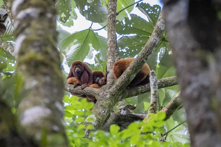
Otún Quimbaya Flora and Fauna Sanctuary
The other option is the Otún Sanctuary. This is a more remote place, but don’t worry, it is perfectly safe. This park protects a sample of the sub-Andean jungle, one of the richest in Colombia.
Red Howler Monkey – Otún Quimbaya Flora and Fauna Sanctuary
It is a perfect place to get in full contact with nature, and to walk a lot. You can also observe the native flora and fauna.
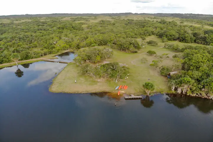
4. The Eastern Plains for Kids: Lagos de Menegua
Lagos de Menegua is a hotel-reserve in the heart of the eastern plains of Colombia. It is also a very safe place and has a spectacular landscape. It is home to more than 800 species of mammals, fish, reptiles, and birds, including the traditional chigüiros (or capyvaras), yamus, pumas, crocodiles and lizards of the eastern plains.
Lagos de Menegua Hotel & Bioreserve
What to do?
There you can go on hiking routes, safari, biking, horseback riding, kayaking, fishing, spend an afternoon at the pool, and more, all in one place!
Kids fishing mojarras in Lagos de Menegua
At night you can go to see the stars, this is a unique experience since light pollution is very low in this region.
The Lagos de Menegua Bioreserve is one of the few privileged places that still have black skies. It is frequented by astronomers and amateurs from all over the world, for observation and photography of constellations, the Solar System and the Milky Way.
Its privileged location allows the simultaneous observation of the northern and southern hemispheres – a great experience for the whole family!
Explore the Surroundings
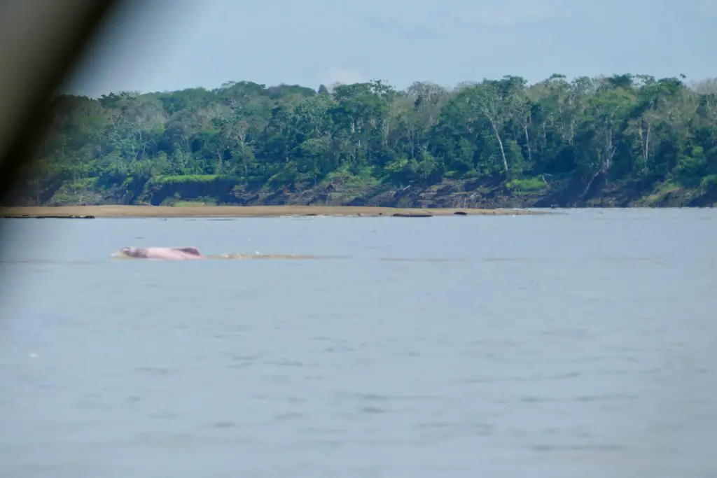
Additionally, from Lagos de Menegua you can go to the city of Puerto Gaitan and there embark on an aquatic safari along the Meta, Manacacias, and Yucao rivers.
You don’t need much luck to be able to see monkeys, turtles, otters, reptiles, and especially the Toninas, the river dolphins. An unforgettable trip for the whole family!
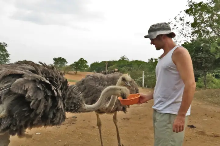
Ostrich Park, Puerto López, Meta
There are two more places that you can visit from Lagos de Menegua: the Obelisk, which is the geographical center of Colombia, and the Ostrich Park, where you will know everything about these birds.
5. San Cipriano Nature Reserve in the Pacific
This is a destination little known by foreigners, but worth visiting with your whole family.
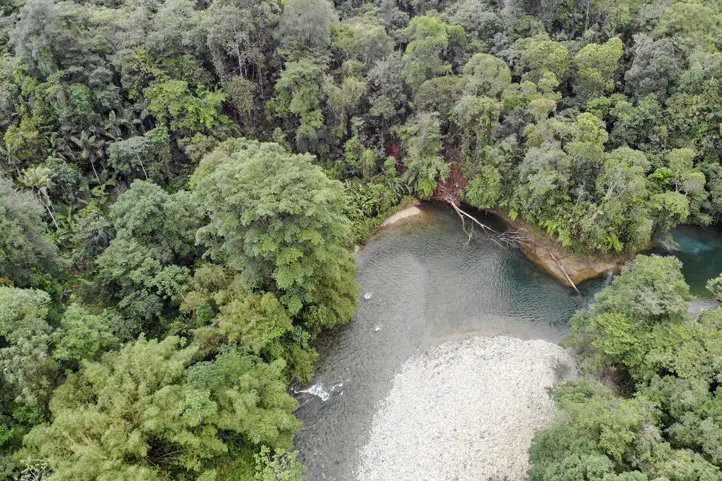
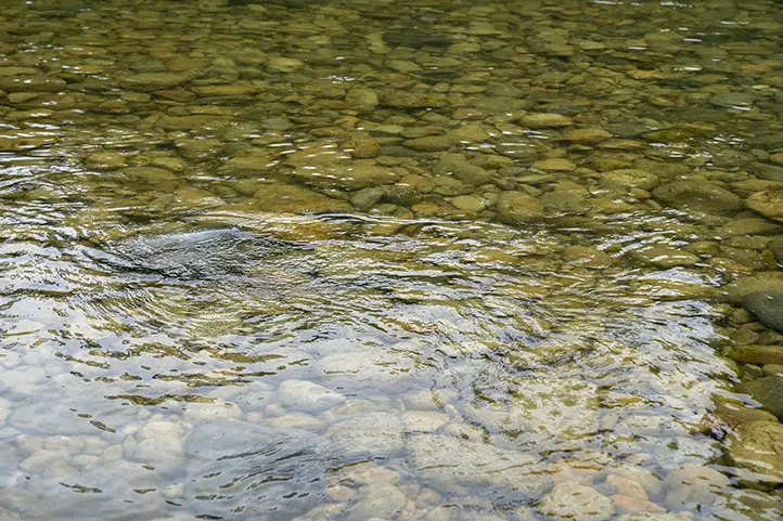
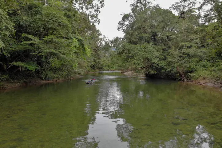
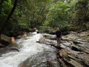
San Cipriano is a natural reserve located in the Colombian Pacific, in the department of Valle del Cauca. This place has one of the purest and cleanest crystalline rivers in Colombia. It is a perfect place to swim and float on tires (tubing) while the slow current drags you through the dense subtropical jungle.
San Cipriano Nature ReserveCristaline Waters of San Cipriano
The huge reserve also has numerous hiking trails, which you can walk through day and night.
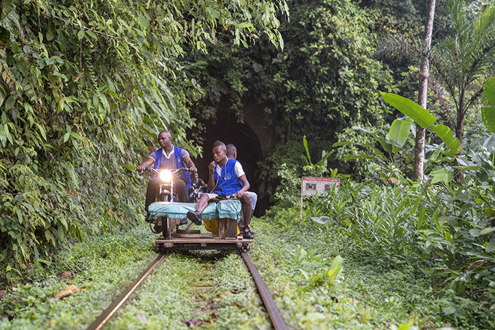
The “Brujitas”
One of the most exciting parts of the trip is the entrance to the reserve. You will enter in some small carts, called Brujita, which is attached to a train track, and moved by a motorcycle. It is a 30-minute ride where you will feel like you are being engulfed by the rainforest tropical jungle.
Brujitas transportation of San Cipriano
What to do?
Spend a day in San Cipriano bathing in the rivers and natural lagoons, walking, and admiring the fauna and flora of this region. There are plenty of animals to see there as toucans, sloths, turtles, and many special birds. You can also stay in the town of San Cipriano, but the hotels offer very basic services.
Tubing along the River of San Cipriano
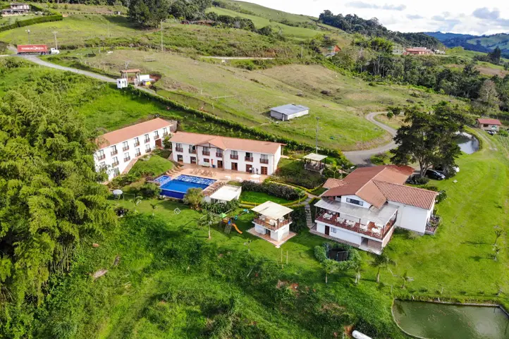
I recommend you to stay in Cali, or in a closer hotel called Hotel la Huerta. From there, you can go and return on the same day to San Cipriano, and there you will have all the comfort for you and your family.
La Huerta Hotel
This hotel has a swimming pool, a small nature reserve and a vegetable plantation. The hotel manages a farm to table meal plan. There, your kids will learn the processes of organic agriculture, from sowing to eating.
La Huerta Hotel
They can also walk among the plantations, observe birds in the forest and surroundings, or simply relax in the pool.
Another advantage of La Huerta Hotel is its proximity to other nice places you can visit with your kids, such as the Yotoco Reserve, where you will meet the howler monkeys; or the Calima Lake Nautical Club, where you can practice water sports such as sailing.
Calima Lake from La Huerta Hotel
6. The Chicamocha Canyon in Santander
The Chicamocha National Park is another recommended destination if you travel with kids.
There you can enjoy extreme activities such as driving buggies, zip line, paragliding, swinging, and rappeling or canyoning. There are also other activities such as interaction with farm animals, virtual reality experiences and 4D movies.
The park also has an aqua park with large pools and slides. Perfect to ensure fun!
It is a place very close to the city of Bucaramanga, only one hour from Bogotá by plane.
7. Bio-park Guátika and Chicaque Park – Near to Bogotá
If you are in Bogotá, there are many places you can visit with your kids. However, I recommend two places that they might love.
Chicaque Park
First, Chicaque. It is about an hour from downtown Bogotá. This park is a very recommended place for visiting with your kids and meet the high Andean cloud forest of Colombia.
Chicaque Park, landscape from the viewpoint!
The park has seven thematic trails where you can visit waterfalls, discover butterflies and birds, oaks, and breathtaking views.
There you can also do the zip line and canopy activities, horseback riding, bird watching, and even spend the night at the park’s hotel.
Sleeping in a tree house!
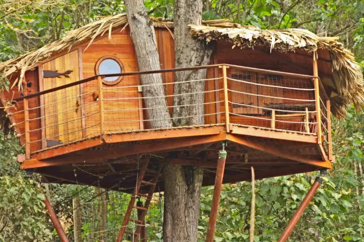
In Chicaque you will find something unique, the possibility of sleeping in the treetops. At this moment, it has two rooms called Nests, with accommodation for 4 to 6 people.
This is a dream experience, as well as unforgettable for the kids, because who didn’t want to sleep in a tree house?
Tree House at Chicaque Park
Guátika Park
On the other hand, there is the Guátika biopark, Only three hours from Bogotá, this zoo has everything for family fun.
Guátika is a place that houses, in the best possible way, animals that for various reasons can no longer be in their natural habitat.
Guátika Hotel Boutique @Booking.com
More than 500 animals are kept there, diverse species of domestic, exotic and wild fauna, in beautiful open and naturalized spaces.
Guátika Park
There, your kids will understand the value of rescuing wildlife and why it is not good to take animals out of their natural environment.
Guátika Park
They will also be able to enjoy adventure activities such as climbing, buggy tours, zip-lining and horseback riding.
You can stay at the biopark hotel, which has beautiful country architecture and the best view of the Sugamuxi Valley.
If you want to know more about the most incredible natural destinations in Colombia, plan your trip with us!
About the author
Sara Colmenares
Current director of Sula. Doctor in Biological Sciences. Her main interests are to explore and understand the organism – environment interactions, taking advantage of emerging knowledge for the management and conservation of species and ecosystem services. She is currently working as a consultant in functional ecology, ecosystem services and conservation projects in Colombia related to ecotourism and birdwatching.
Guaviare is one of the least populated departments of Colombia, and one of the most pristine nature destinations in the country.
Additionally, this department is located in the Colombian Amazon region, although part of its territory is also in the Orinoquia. Its capital is San José del Guaviare.
Brief history of Guaviare
In the past, the colonization of Guaviare was mainly due to the enormous natural riches of its soil and the exploitation derived from these.
People came there to cultivate balata and rubber. Moreover, trade of wild animal skins, native plants and ornamental fish was also common.
Finally, the illicit cultivation of coca attracted many people, bringing also war and chaos to the region.
Today, tourism is opening as a new possibility for the economic development of the region, and it works as a good strategy for the protection and conservation of natural and archaeological areas.
Weather and Landscape
The dry season happens from December to February, and the rainy season during the rest of the year (especially April-July and October-November). Annual rainfall ranges from 2,000 to 3,500 mm. The temperature during the day reaches 25° to 30 °C, dropping at night to 12 °C between July and August.
Its soils are bathed by numerous rivers and a network of streams, divided mainly into two basins: Orinoco River Basin and Amazon River Basin.
Tourism in Guaviare
Tourism is making its way in this destination dedicated to adventure and sustainability. It is an opportunity for sustainable development in he region. The natural environments for swimming, the sunsets, and its ecosystems make it a unique destination.
Archaeological places, and the fauna and flora that make up an abundant biodiversity, are the greatest attraction of Guaviare.
The Most Featured Destinations in Guaviare
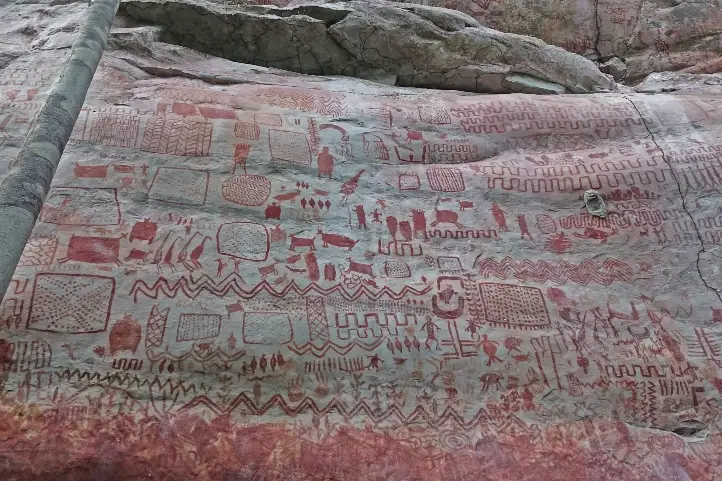
Serrania de La Lindosa and Cerro Azul
Serranía de la Lindosa @Parques Naturales
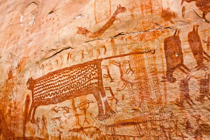
This place is one of the eight archaeological zones declared as a protected area by the Ministry of Culture of Colombia.
Here you will find the famous cave paintings, among others those of the Guayabero River and the Caño Dorado, with vivid colors. In the Cerro Azul in the Serranía La Lindosa, you can observe paintings that are twelve thousand years old.
The summit of Cerro Azul can be reached by a medium level hike of approximately 40 minutes. In Cerro Azul, there are a series of cave paintings painted with reddish pigment by indigenous people who inhabited the La Lindosa mountain range 7,250 years ago.
It is a two-hundred-meter-high peak to explore and walk. During the walk you can find giant trees and native species of flora and fauna. From the top you can see numerous streams of crystalline water and the jungle.
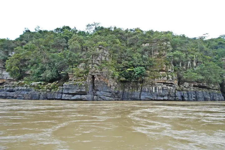
Raudal of the Guayabero
Raudal del Guayabero @ Juan Pablo Rozo – Wikiloc
This spectacular spot is one hour by river, and one hour and thirty minutes by land, from San José del Guaviare.
The Guayabero River, before its encounter with the Ariari, is framed in a canyon formed by walls of rocks of Pre-Cambrian origin.
From there, a current is unleashed that reaches half a kilometer in length. Although it is navigable throughout the year, the summer season is the best time to cross it.
Throughout the tour you can see the gray freshwater dolphin or Tonina (Sotalia fluviatilis), as it is called by the inhabitants of the region.
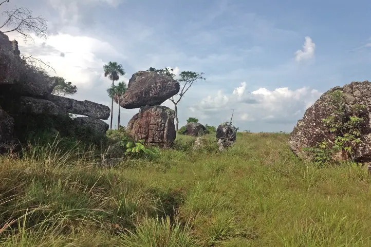
Natural Bridges
Rocky Bridges Pic. by Parques Nacionales
These natural bridges are high and have been shaped and polished by water over time. They stand on a ravine to which it is possible to descend with certified guides.
The Stone City of San Jose, is an enigmatic place that consists of ancestral rocks distributed with an impressive and mysterious symmetry.
In the company of guides, you can tour this site that has labyrinths, caves, and monoliths with very old petroglyphs. A special place for hiking and caving.
Natural Baths of Agua Bonita, Villa Luz and Tranquilandia.
Tranquilandia Bath
They are located only five miles from the city, in Caño Sabana. The ancient rock formations form pools of crystalline waters of different colors. The rich plant and mineral environment is the one that colors these waters, so it is very similar to the rainbow river in La Macarena. You can go there and enjoy a good swim and landscape.
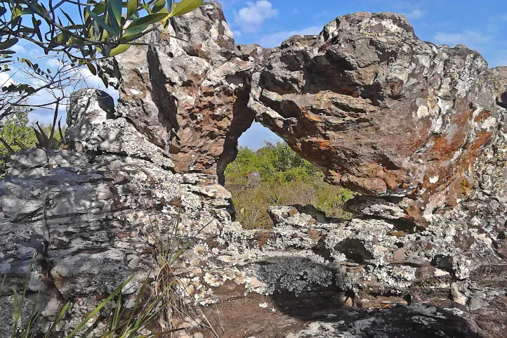
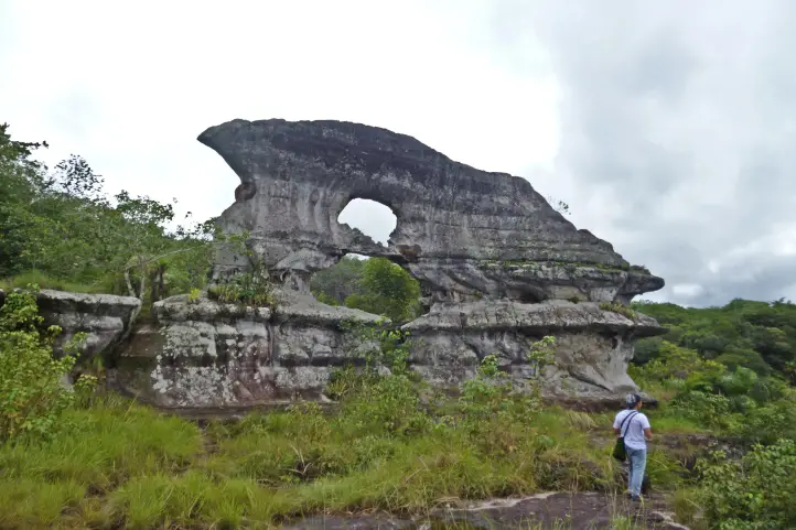
Puerta de Orión
Puerta de Orión Pic. by Parques Nacionales
Orion’s Gate is a rock formation emblematic of the city, found 9 kilometers from San José del Guaviare. It is twelve meters high and 20 meters wide. It has two natural holes, one on top of the other.
To get to Puerta de Orión you must pass through cavities and cornices that make it an enigmatic scenery.
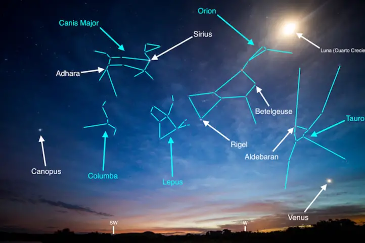
The particularity of this natural wonder is that in the summer solstice you can observe Orion’s Belt through the upper window, creating a unique spectacle.
Laguna Negra is located 11 kilometers from San José del Guaviare. The black color that the water projects is because at the bottom there are decomposed leaves from the surrounding forests.
Its name is due to the dark tone of its waters seen from the air. Once on land, you can see a scenario of crystalline water, according to experts, because of the thick vegetation that surrounds it.
This natural reserve, 11 km from San José del Guaviare, constitutes the ideal scenario for the practice of artisan fishing and snorkel. You can find “cachazas” and “payaras”.
Kayaking and sailing, among other practices, are part of the new offer.
Because it is a complete planetary treasure, in 2018 it has been declared a mixed heritage of humanity.
It is located in the departments of Caquetá and Guaviare, and preserves the largest sample of rock art in the world.
In Chiribiquete there are approximately 70,000 paintings and 50 panels of an average height of 7 meters.
These have served to distinguish a cultural tradition of roots, apparently very old, of the Paleo-Indian. Therefore, they have been associated with groups of hunter-gatherers of the Tropical Rainforest and semi-dry enclaves of the Guianas and the Amazon.
Other Attractions
Guayabero Pic. by Juan Pablo Rozo – Wikiloc
Rural and community tourism: Finca Chontaduro, Finca Diamante, replacement of coca for fruit.
The “Flor del Guaviare” (Paepalanthus formosus Moldenke) is one of the emblems of the department.
The trip Bogotá – Guaviare by plane takes about 1.20 hour. The tourist sites are easily accessible by 4X4 vehicles. The capital, San José del Guaviare, has become a center of operation with a wide range of lodging facilities: three stars hotels, hostels, and camping.
Where to stay in San José del Guaviare
We recomend you the following hotels in San José del Guaviare:
Hotel Quinto Nivel
Hotel Aeropuerto
If you want to know more about the most incredible natural destinations in Colombia, plan your trip with us!
Current director of Sula. Doctor in Biological Sciences. Her main interests are to explore and understand the organism – environment interactions, taking advantage of emerging knowledge for the management and conservation of species and ecosystem services. She is currently working as a consultant in functional ecology, ecosystem services and conservation projects in Colombia related to ecotourism and birdwatching.
Minca is a small town located in the foothills of the Sierra Nevada de Santa Marta, 650 meters above sea level, and about 14 km from the center of the city of Santa Marta, in the department of Magdalena, northern Colombia.
Brief Intro about Minca
It is considered the ecological capital of the Sierra Nevada de Santa Marta. It is a region with a vocation for coffee, and for many years it attracted inhabitants from the north of Santander who took advantage of its land and climate for the cultivation of coffee.
Coffee Production in Minca, Sierra Nevada de Santa Marta
In the past, it was an area marked by armed conflict. Today it is a safe place. However, in Colombia, and everywhere, it is better not to give papaya. I recommend you not to go out without the accompaniment of a certified guide, especially if you go to the waterfalls or to the hotels outside the city, and at night.
Minca has a rich archaeological history and is an ecological paradise with the crystal clear Minca River and its immense green vegetation.
This place served in the past as a habitat for the Tayrona culture. Today they are found in the indigenous peoples belonging to the Kággaba (Kogi), Ijka (Arhuaco), Wiwa (Arzarios) and Kankuamo in the highlands.
Minca has multiple lodging sites, it is the corner of painters, sculptors and artisans. There are also several coffee producinghaciendas that have opened their doors to tourism.
If you decide to visit Minca, in this blog you will find a travel guide to Minca, learn what to do in Minca, where to stay in Minca and more.
How to get to Minca
No matter where you come from, to get to Minca you will have to get to Santa Marta first.
Once in Santa Marta, you can book a private transfer to Minca from Santa Marta which does offer convenience. Some people prefer to arrive by cab or even by motorcycle.
Once in Minca, motorcycle or 4×4 car become the only transportation option, especially in the rainy season which is from October to December and from April to May.
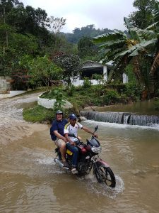
Roads in Minca during rainy season
If you are going to the higher areas, it is necessary to go up by motorcycle or 4×4 car, since the road is not paved, it is narrow, and when it rains it becomes a river of water, and a reservoir of mud. But don’t worry, I promise you that the experience can be really fun!
What you can do in Minca
Thanks to its geographical position, Minca and its surroundings have different attractions.
It is a place where you can enjoy a cooler climate if you come from beach areas like Cartagena or Santa Marta.
There you can do everything related to nature tourism: hiking, mountain biking, bird watching, water tourism in rivers and waterfalls, adventure, rest and coffee.
Bird watching
Minca’s altitudinal gradient makes it a very interesting destination for bird watching, also because it is located in the Sierra Nevada de Santa Marta, which is a hotspot of endemism not only for Colombia, but worldwide.
Two hours by car from Mica is the El Dorado Natural Reserve, ideal for observing endemic species of the Sierra Nevada.
In its surroundings there are about 300 species of birds, both resident and migratory. It is a region of coffee plantations, with habitats ranging from dry forest, rain forest, cloud forest, and páramo (moorland) in the higher parts.
W Santa Marta Antbird – Drymophila hellmayri ENDEMIC
Among the most striking species are Santa Marta Brush-finch, Sierra Nevada Brush-finch, Santa Marta Parakeet, Scarlet-fronted Parakeet, Santa Marta Warbler, Santa Marta Foliage-gleaner, Santa Marta Antbird, White-lored Warbler, Santa Marta Tapaculo, Brown-rumped Tapaculo, Whooping Motmot, Golden-winged Sparrow, Santa Marta Emerald Toucanet, White-tipped Quetzal, Santa Marta Blossomcrown, and many others.
Wildlife Watching
In addition to bird watching you can go on night safaris, especially around El Dorado Natural Reserve.
In Minca you can find the habitat of many species and there is a high concentration of endemic species, not only birds, but also frogs, reptiles, butterflies, plants and beautiful landscapes.
Butterfly watching in Minca, Sierra Nevada de Santa Marta
Hiking and Trekking
Minca is also an ideal destination for trekking. There are several routes, but among the most recognized are Las Piedras, Los Pinos and Cerro Kennedy.
The most recommended hike is of medium intensity, with one day of duration, and 11 km of route. It begins by leaving Santa Marta by land transport to Finca La Victoria, where you can learn about the process and history of coffee in this region.
From there you will continue walking and getting to know viewpoints and the diversity of bird species until you reach the area of Los pinos, 1,300 meters above sea level. From Los Pinos you will descend to the waterfalls of Marinka, being the final and refreshing point of the tour.
Views of the Sierra Nevada de Santa Marta from Minca
Cerro Kennedy is another good destination for trekking in Minca. Most travelers choose to do this route on foot, but for mountain bike fans, there is a mountain biking route as well as the option to go up by bike.
The hike to Cerro Kennedy is of a moderate to difficult level. It is a 25 km route from Minca, to go and back takes two days. You will go from 650 meters above sea level, to 2700 meters. There you will find fascinating views of the Sierra Nevada de Santa Marta.
Water Tourism
Visiting rivers and waterfalls in Minca
Pozo Azul
After a 45 minute walk from the center of Minca, you will find Pozo Azul, which crosses the Minca River.
Cascades of Marinka
They are found after a walk of 90 minutes from the center of the town. You will have to pay for a small admission fee.
At Marinka you will find two waterfalls, one of them with a natural pool. There are also bathrooms and a café.
Adventure
Cycling or Mountain Biking in Minca
There are many plans and routes in the mountains and around Minca. You will be able to live an incredible adventure full of adrenaline. There are tours from beginners to advanced.
Rappel down waterfalls.
You can practice rappelling in the Marika waterfalls.
Coffee and Beer Experiences
La Victoria Farm
La Victoria was founded in 1892 and is one of the largest and oldest coffee estates in northern Colombia. It is located about a 90 minute walk from the town of Minca.
Coffee Production in Minca, Sierra Nevada de Santa Marta
In addition to producing top quality organic coffee, La Victoria is home to Nevada, a small brewery that makes artisanal beer using pure mountain water and local products such as coffee and coca leaves.
La Victoria has also embraced tourism as an alternative source of income, offering guided tours that explain the history and operation of the coffee farm, you can learn the entire process of cultivation and preparation for export, and see their early 20th century machines that run on hydroelectric power.
The farm also has its own nature reserve for the enjoyment of bird watchers and nature lovers.
Where to stay in Minca
Minca has many houses, hostels and farms that offer their guests comfort and tranquility. They are available in all types and prices. Here I will recommend some of the best options:
Current director of Sula. Doctor in Biological Sciences. Her main interests are to explore and understand the organism – environment interactions, taking advantage of emerging knowledge for the management and conservation of species and ecosystem services. She is currently working as a consultant in functional ecology, ecosystem services and conservation projects in Colombia related to ecotourism and birdwatching.
The lakes of Colombia are not lakes proper. Due to its extension, the water deposits of the Andean mountains are only lagoons. The largest are: Lake Tota, located at 3,115 meters above sea level in Boyacá, and Lake La Cocha, at 2,660 meters above sea level in Nariño. In Cundinamarca there is the Lake Fúquene and others of great importance Like the Suesca and Guatavita lagoons.
But don’t get confused! In Spanish lago (lake) and laguna(lagoon) definitions are not the same as in English.
In Spanish, a lake refers to a body of water that has an entrance and an outlet of rainwater, groundwater, and/or rivers, for example, the Lake Michigan or the Lake Superior in the USA, or the Lake Tota in Colombia. A lagoon, on the other hand, is a body of standing water that has an inlet from rivers or streams, but no outlet, for example the Great Salt Lake in the USA, the Caspian Sea in Asia, the Lake Corangamite in Australia, the Laacher See in Germany, and Lake Titicaca in Bolivia.
Now, in English, the difference between a lake and a lagoon, as well as its definition, is quite different. Lagoon is defined as a type of saltwater lake that is formed by the waves of the ocean. Also, lagoon is close to the ocean, whereas lakes are far away from oceans.Lagoon is saltwater body, whereas lakes are mostly freshwater bodies. Lagoons are generally shallow compared to lakes. And so on…
For an equal understanding, this is what you may call an exorheic and an endorheic basins, i.e. open and closed lakes respectively. And, translating to Spanish, lakes are exorheic and lagoons are endorheic basins. If you arrived here because of a homework about lakes visit National Geographic Encyclopedia about lakes. So… what is this post about?
Lagoon. In Spanish, a lagoon is a body of standing water that has an inlet from rivers or streams, but no outlet.
Lake. In Spanish it means a body of water that has an entrance and an outlet of rainwater, groundwater, and/or rivers.
Ok. This post is about the lakes of Colombia you can visit for fun and enjoy nature. Lakes of Colombia are also known, and called, as “lagunas” (lagoons), but they are not like the lagoons you are used to know. So, don’t get confused, when you visit a “lagoon” in Colombia, it will be, for sure, very far from the coastal zone, and it will be a freshwater lagoon, as you may have already noticed. And it can be lake… or not… geez!
In parentheses you will find the real type of water body that each lake or lagoon belongs to, according to the definition in Spanish.
Exorheic Basin. With an area of nearly 55 km², it is the largest lake in Colombia and, after Titicaca, the second highest navigable lake in South America at 3,015 meters above sea level (9891.7 Ft.).
In the southwestern part of the lake, there is a natural bay called Bahía Blanca. It is frequented by bathers and water sports enthusiasts despite the low temperature that usually does not exceed 12 °C.
What to do
Despite the stories about the Tota Lagoon monster(Diabloballena), as terrifying as the Loch Ness monster (Nessie) in Scotland, today you can practice water sports, sportfishing, navigate the lake, walk through the forest, camp and enjoy Playa Blanca, the only cold-weather beach in Colombia.
When sailing you can visit the islands of the lagoon: El Sagrario de los Milagros, San Pedro, Cerro Chino, Santo Domingo, Isla del Amor and La Ballena.
Laguna de La Cocha
(La Cocha Lagoon, exorheic)
Location
Characteristics
Lake La Cocha, also called Lake Guamués, is a natural lagoon of glacial origin, located in El Encano, a village in the municipality of Pasto, in the department of Nariño. With an area of nearly 40,5 km², it is the second largest natural body of water in Colombia, after the Laguna de Tota. It is located at 2680 meters above sea level (8792.6 ft.)
In 2000, Colombia registered the La Cocha lagoon, or Guamués lake, as a wetland of national and international importance within the Ramsar Convention, being the first with this qualification in the Colombian Andean region.
What to do
In this place it is possible to take boat trips, do sport fishing and bird watching.
Inside the lagoon there is the smallest flora sanctuary of Colombia, the Isla de la Corota Flora Sanctuary, with 15.2 hectares. It is located in the north of the Laguna de la Cocha. It is considered as a source of sacred energy for the indigenous and traditional doctors of the region. Likewise, it has a chapel that is an important pilgrimage site for Catholics, especially during the Virgen de Lourdes Festival. There you can walk trails designed to observe the forest.
Laguna de Guatavita
(Guatavita Lagoon, endorheic)
Location
Characteristics
This is the most famous sacred lake among our pre-Hispanic ancestors. The legend of El Dorado derives from it, a story that brought many people crazy about its relentless thirst for gold and wealth. The lake has suffered failed drainage attempts, made by these crazy treasure hunters.
It is located in the eastern mountain range of Colombia, at an altitude of 3,100 meters above sea level (10170.6 ft.) and has a temperature of 5 to 11℃. the lagoon has a maximum width of 0.7 km, a surface area of 19.8 hectares and an average depth of 125 m. It is supplied mainly by groundwater. It was formed in a perfectly circular mountain depression, surrounded by native forests. There are several hypotheses about its formation: by a meteorite, by a collapse caused by the dissolution of saline strata, or by glacial action and erosion. Today it has reached a stage of sedimentation.
What to do
Its environmental recovery has allowed that, after many years, activities can be carried out such as hiking, and landscaping.
Laguna de Fúquene
(Lake Fúquene, exorheic)
Laguna de Fúquene. Picture by Francy Ramírez
Location
Characteristics
With an area of 30 km² and located at an altitude of 2540 meters above sea level (8333.3 ft.), the Fúquene lake has numerous islands, one of which was a sanctuary for the Muiscas. According to the legend, hidden under the waters and ready to defend his domains in the valley of Ubaté and Chiquinquirá, remains Fu, a god-demon with the head and tail of a fox and human body. His name in Chibcha is decomposed from “Fu” which means fox, and “quene” which means bed, which would be translated as the bed of the fox.
The local community depends directly on the lagoon, since it is a source of water for domestic, agricultural and industrial activities. It is also the habitat of several migratory and endemic species.
What to do
Its environmental recovery has allowed that, after 40 years, nautical activities can be carried out with small boats such as sailboats, kayaks and rowing surf.
The Otún lagoon is one of the highlights of the Los Nevados National Natural Park. This lake measures about 1.5square kilometers and is located at 3,950 meters above sea level (12959.32 ft.) in páramo ecosystem, being perhaps one of the highest that you can visit. Formed by volcanic and glacial action, it is fed mainly by the snowmelt of the Nevado de Santa Isabel. It is one of the most beautiful ecological hiking destinations in Colombia. It is located in the department of Risaralda, Colombia. Its waters seep under caverns formed by volcanic flows and give rise, together with Laguna La Leona, to the Otún River, which is the source for the aqueduct of the city of Pereira.
What to do
This lake is a great tourist attraction in Risaralda for its great beauty and for trout fishing. The trout is a species introduced to the lake. In the lake you can see the Ruddy Duck (Oxyura jamaicensis), owls and hummingbirds, while the landscape is dominated by frailejones (Espeletia sp.) and typical páramo grasslands. Besides fishing, you can also camp there.
The Iguaque lagoon is located near the municipality of Villa de Leyva in the department of Boyacá, Colombia. It has an area of 6.75 km² and an average depth of 105 m. It is located at 3,800 meters above sea level (12467.19 ft.) in the páramo ecosystem, with a temperature from 4 to 12ºC on average.
According to the Muisca legend, the goddess Bachué came out of the lagoon with a child, giving rise to the entire human race. Bachue is the “Good Woman” mother goddess of the Muiscas.
What to do
Visiting this sacred lagoon is believed to cleanse the soul and purify the spirit. The lagoon is protected as part of the Iguaque Fauna and Flora Sanctuary. There you can go hiking, go on scientific and research tours, observe fauna and flora, observe the cultural heritage, and enjoy the landscape.
The Laguna de Sonso or del Chircal, was decreed as a Natural Reserve since 1978 and regulated for the use of land, water and airspace in 1979.
It is located on the right bank of the Cauca River, between the municipalities of Buga, Yotoco and Guacarí, in the department of Valle dal Cauca. It has an area of 2,045 hectares, (covering 14 square kilometers of these municipalities), of which 745 correspond to the lagoon zone and 1,300 to the buffer zone. It is located 936 meters above sea level, with an average temperature of 23ºC, and a relative humidity of 75%, being an attractive space for various species.
What to do
The Lake Sonso is part of the RAMSAR international agreement signed on February 2, 2017. It has a perfect combination of aquatic birds and dry forest. In addition, it is a refuge for migratory and endemic bird species, totaling more than 300 species. For this reason the main tourist activity in the Sonso lagoon is bird watching and bird photography.
Lagoons at Natural National Park Chingaza
(Lakes of Chingaza, exorheic)
Lakes of Chingaza National Natural Park
Location
Characteristics
The beautiful Chingaza National Natural Park is located in the eastern Andean mountain range of Colombia, between 3,050 and 3,950 meter above sea level (9858.924 – 12959.32 ft.). It has a great water richness constituted by the upper basin of several rivers, as well as by a lagoon system which has been declared a Ramsar site.
The Lacustrine system of Chingaza is formed by 20 lagoons and wetlands that supply water to the capital city, Bogotá. It is also of great importance for migratory birds.
Among all the lagoons, the largest is the Chingaza lagoon, with an area of 88 hectares, which contributes a high percentage to feeding the aqueduct that provides water to the city of Bogotá.
What to do
Four of the 6 trails enabled for ecotourism in the Chingaza park are to visit different lagoons:
You can do guided mountaineering in the modality of “hiking without camping” towards the lagoons. You can also contemplate the landscapes of lagoons, wetlands and streams, as well as observe the flora and fauna of the páramo.
Lakes of Tarapoto
(Lakes of Tarapoto, exorheic)
Amazon river dolphin (Inia geoffrensis), at Puerto Nariño, Amazonas department, Colombia.
Location
Characteristics
It is located in the municipalities of Puerto Nariño and Leticia, department of Amazonas. The lakes of Tarapoto are a strategic ecosystem made up of more than 30 interconnected lakes, which reach an approximate area of 11,424 m2 in periods of low water. According to Ramsar.org, this ecosystem:
“provides important functions such as flood and erosion control, waterways for transportation, recreation and tourism.”
Besides being one of the greatest ecotourism attractions in the region, this biome is the means of subsistence and food for 22 indigenous communities, Cocama, Ticuna and Yagua, which are part of the Ticoya reservation in the Amazon.
It has been declared a Ramsar area in 2018, thanks to the joint work between the inhabitants of Puerto Nariño, the indigenous people of the Ticoya reservation, the Omacha Foundation, the Colombian government, Corpoamazonía, the Sinchi Institute and the World Wide Fund for Nature (WWF).
What to do
There you can arrive by boat and wait in silence for the appearance of pink dolphins, while contemplating the majesty of the Amazon jungle.
Lagoons at Natural National Park Sumapaz
(Lakes of Sumapaz, exorheic)
Páramo of Sumapaz
Location
Characteristics
Bogotá has the largest and most beautiful páramo in the world, the Páramo of Sumapaz. This ancestral place was considered by the Muiscas as the habitat of the gods.
Here you can enjoy unique landscapes, unique animals and the particular vegetation of an ecosystem that is dedicated to safeguarding water: the páramo.
What to do
In the Sumapaz páramo you can visit the following lagoons:
Alar Pasquilla Lagoon
According to the District Tourism Institute of Bogotá, the Alar Pasquilla lagoon is one of the seven wonders of the city. This sanctuary full of frailejones, imposing cliffs and a 3,200-meter-high viewpoint is a unique plan.
Negra lagoon
This body of water has been the object of legends, which is why it can be considered the most mysterious lagoon in the páramo of Sumapaz. In pre-Columbian times, when the Zaque de Hunza (Tunja) and the Zipa de Bacatá (Bogotá) were at war, it was known as the Saguanmachica lagoon, because a zipa with that name was crowned there.
Los Colorados Lagoon
Also known as the enchanted lagoon, this paradise is a place that few know because of its difficult access.
Los Tunjos
They are the best known bodies of water in Sumapaz because it is easy to get to them. This area has a forbidden route, where you can see lagoons and cliffs as high as the Colpatria building.
Larga Lagoon
In this lagoon of the Sumapaz National Natural Park it is common to see fish, wild ducks and other types of birds. Access is very easy, because it is close to the Los Tunjos complex.
Laguna Cajitas lagoon
This body of water at 3,850 meters high is famous because the Black-chested Buzzard-eagel can be seen frequently. The best panoramic view of the lagoon is on Cerro La Carolina, a difficult place to access because you have to climb for about an hour.
Laguna de Cumbal
(Lake Cumbal, exorheic)
Location
Characteristics
The Cumbal lagoon, also called La Bolsa lagoon, is located at the foot of the Cumbal volcano, at 3440 meters above sea level (11286.09 ft), in the department of Nariño, south of Colombia.
This lagoon is characterized by the gray color of its waters, the very low temperature and the absence of waves. The Cumbal lagoon basin is small in size (9.8 km²) and is located in a very sensitive aquifer recharge zone.
It is a sacred place for the indigenous people of the region, who belong to the grasslands ethnic group, and according to them, humanity originated there. For this you infer this place is of feminine energy, and it recalls the uterus of a woman, that is why it is called the bag.
What to do
You will be able to enjoy a majestic landscape of mountains, valleys, nearby volcanoes and see the snow-capped mountains of the Republic of Ecuador.
You can also do sport fishing activities, since the rainbow trout abounds in its waters. You can also meet the indigenous inhabitants of the area, their culture, traditions and gastronomy.
Recommendations
To enjoy it to the fullest, we recommend you take comfortable, warm and waterproof clothing. You should also wear mountaineering boots that are waterproof. In some places you may be short of breath due to the altitude, in that case, breathe deeply and slowly, and walk at your own pace. There will always be people watching over you and taking care of you so that you get the best experience.
If you want to know more about Colombian nature tours, or want to visit any Lake of Colombia, follow us, write us comments, or just contact us.
Rutas de los Andes Blog https://rutasdelosandes.com/
Wikipedia
WikiAves de Colombia
Colombia Travel
Colparques Website
National Natural Parks of Colombia Website
Ramsar.org
Semana Journal
About the author
Sara Colmenares
Current director of Sula. Doctor in Biological Sciences. Her main interests are to explore and understand the organism – environment interactions, taking advantage of emerging knowledge for the management and conservation of species and ecosystem services. She is currently working as a consultant in functional ecology, ecosystem services and conservation projects in Colombia related to ecotourism and birdwatching.