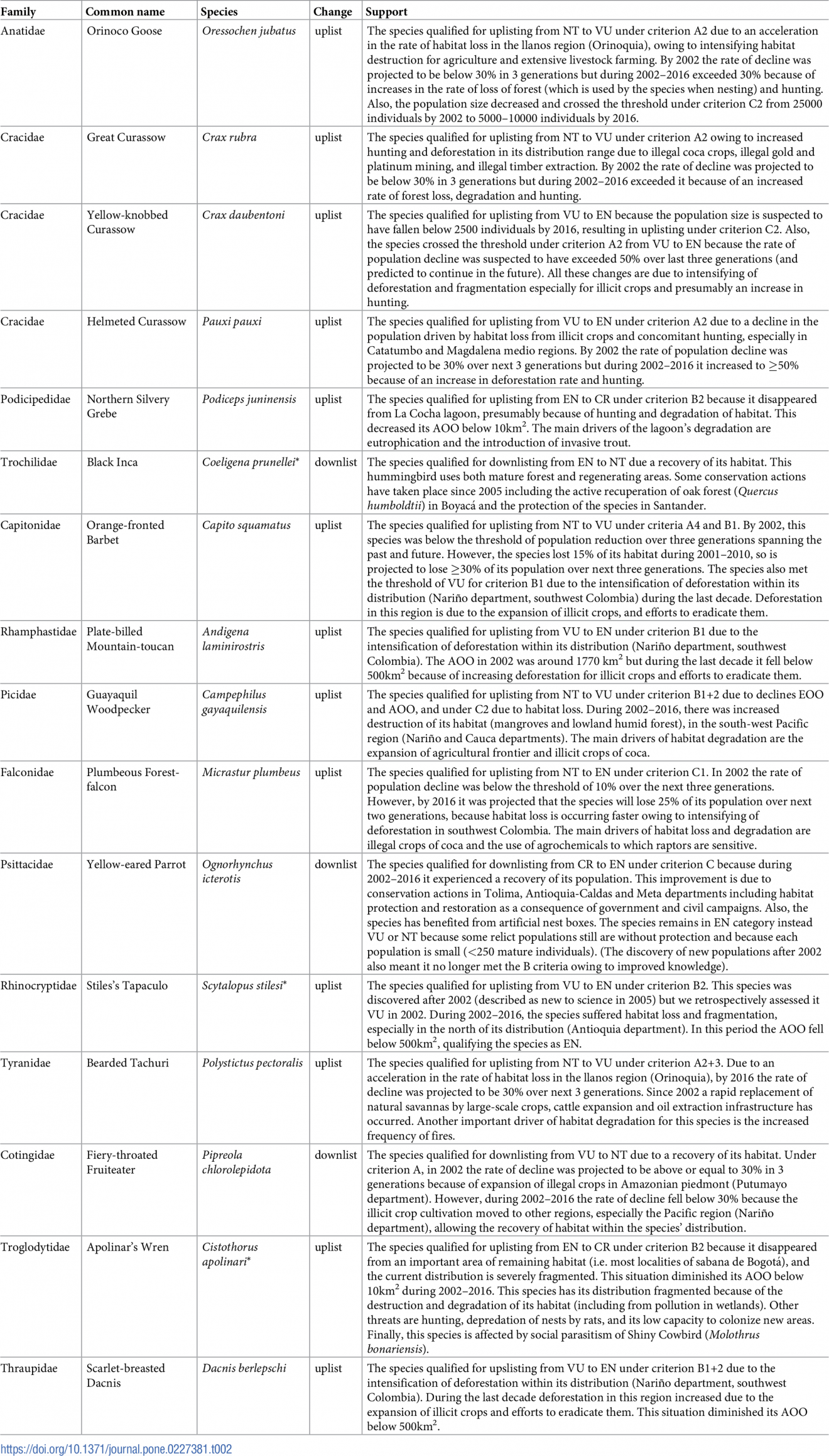
14 Unique Monkeys you Cannot Miss in Colombia

Colombia is one of the countries with the largest diversity of monkeys. It is ranked as the sixth country in the world, and the third in the region after Brazil and Peru. Such diversity is associated to Colombia’s geographic location and topography.

Colombian primate species, aka Colombian monkeys,  are a good example of Neotropical monkeys, since we have representatives of the three families recognized for the American continent: Cebidae, Pithecidae and Atelidae. The department with the largest number of species is Cauca, since it includes Andean, Chocó and Amazonian Piedemont areas, each of these regions usually has some particular species.

Below you will know and discover some of the most unique monkeys that you can find in Colombia.

Discovering the endemic monkeys of Colombia

Brumback’s night monkey – Aotus brumbacki

Brumback’s Night Monkey – Aotus brumbacki

Where to find it: Arauca, Boyacá, Casanare, Cundinamarca, Meta, Vichada

Conservation status: Vulnerable

Habitat: inhabits at low altitudes in Colombian Eastern Plains, usually in dense forest, fragmented forest, gallery forest and riparian forest.

It is also found in a small part of Apure State, Venezuela. Its western range extends from the foothills of the Eastern Cordillera between the Arauca River to the north and the Guaviare River to the south.

They are nocturnal animals, being mainly active on full moon nights. During the day they take refuge mainly in tree hollows to rest. They are monogamous and congregate in groups of 3 to 5 individuals.

Hernández-Camacho’s night monkey – Aotus jorgehernandezi

Where to find it:  Habitat: Quindio and Risaralda, it is possible that it occurs in Tatamá Natural National Park.

Conservation status: Data deficient.

Habitat: dense forest, fragmented forest, gallery and riparian forest and secondary or transitional vegetation.

It is a nocturnal species, first described in 2007 by Thomas Defler and Marta Bueno, two of the most important primatologists of Colombia.

This monkey has a gray neck and a white spot over each eye, separated by a black band. The skin on the chest, belly, lower arms and lower wrists is thick and black.

Gray-handed night monkey – Aotus griseimembra

Where to find it:  Sinú River, including the Sierra Nevada de Santa Marta and the Magdalena River, Cauca River and Sao Jorge River valleys. It can be found in the border with Venezuela near to Maracaibo.

Conservation status: Vulnerable.

Habitat: tropical dry forest. It is arboreal and nocturnal.

This little monkey eats fruits, flowers, leaves, nectar, and insects. A curious fact of this monkey is that it is monogamous, and communicates visually. Also, male and female are identical. The Gray-handed night monkey is an important dispersor of seeds and are also potential pollinators for trees, and it is used by scientists as a model because it is resistant to VIH-1.

The hair on the back of the hands and feet is the color of light coffee with darker hair tips, a key distinguishing feature from other A. lemurinus subspecies.

Varied white-fronted capuchin – Cebus versicolor

Where to find it:  Middle and high Magdalena Valley.

Habitat: Lowland moist forest and palm swamps in the Río Magdalena Valley of northern Colombia

Conservation status: Endangered.

It was classified as a subspecies of the white-fronted capuchin (C. albifrons) but genetic analysis revealed it to be a separate species.

Santa Marta white-fronted capuchin – Cebus malitiousus

Where to find it:  Magdalena

Conservation status: Endangered

Habitat: The habitat where this species can be seen is in Mosaic of crops with natural spaces Gallery and riparian forest.

This primate is a medium-sized monkey, is characterized by a color that is rather dark brown over almost the entire body with yellowish shoulders.

It is omnivorous, feeding mainly on fruits, invertebrates, other plant parts and sometimes small vertebrates.

Colombian black-handed titi – Cheracebus medemi

Where to find it:  Putumayo and Caquetá.

Conservation status: Vulnerable.

Habitat: Inhabits tropical rainforest in southern Colombia, and this is one of the species most affected by climate change. They live in family groups and are monogamous.

The Colombian black-handed titi is territorial, and vocalizes loudly when couples from other groups enter their own territory.

Their diet consists mainly of fruits. To a lesser degree they also eat other parts of plants and insects.

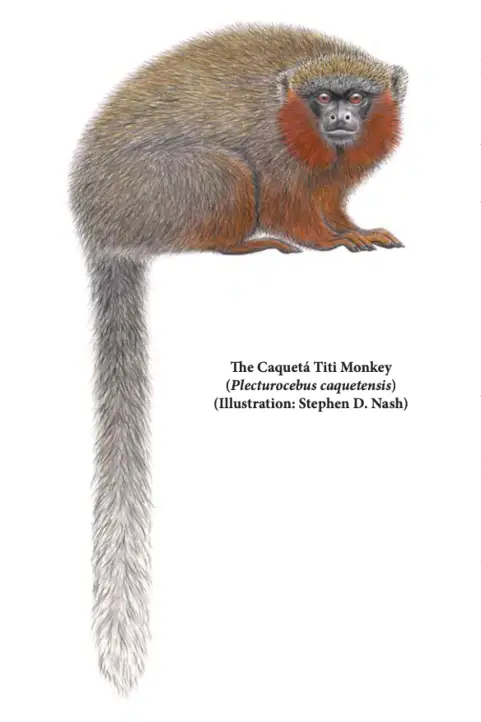
Ornate titi – Plecturocebus ornatus

Where to find it:  Caquetá.

Conservation status: Critically endangered.

Habitat: This species can be seen in the following habitats: Dense forest, fragmented forest Secondary or transitional vegetation Mosaic of crops, pastures and natural spaces Gallery and riparian forest.

It is a miniature monkey with a graceful red beard, discovered in the Colombian jungle. Its fur is grayish-brown, it does not have a white band on its forehead and is the size of an average domestic cat.

They have one offspring per year and, when the offspring arrive, the parents usually force the eldest of the offspring to leave the group, to concentrate their attention on the newborn. Family groups of this species stay together in groups of up to four individuals.

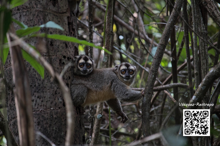
Caqueta Tití – Plecturocebus caquetensis

The Caquetá Titi Monkey (Plecturocebus caquetensis) (Illustration: Stephen D. Nash)

Where to find it:  Caquetá.

Conservation status: Critically endangered.

Habitat: It usually inhabits the humid forests between the Caquetá and Orteguaza rivers, in the northwestern Amazon, southern Colombia.

Its body measures between 35 cm in length and its tail 61 cm, weighs between 800 and 1400 g. Their body fur is abundant and reddish on the neck; the end of the tail is black with white tips.

They are monogamous and form small groups of 3 to 6 and preferably 4 individuals.

White-footed tamarin – Saguinus leucopus 

Where to find it:  Confined to restricted forest patches in the Magdalena River valley towards the center and north of Colombia, particularly in the departments of Antioquia, Bolívar and Tolima; between 0 to 1600 m.a.s.l.

Conservation status: Vulnerable

Habitat: This primate is found in dry tropical, humid tropical, very humid tropical and very humid premontane forest (under the Holdridge scheme). This species uses different types of habitat: primary forest and secondary forest with several years of regeneration, preferably using primary forest.

The White-footed tamarin is very similar in appearance to the cotton-top tamarin, from which it is separated by the Atrato. Its average weight is 440 grams. These primates are diurnal and arboreal, active and agile. They move constantly and quickly between trees, and can jump up to four meters between them.

The back is pale silvery brown, or yellowish white variegated with brown. The face is almost naked with some thin white hairs. The forehead is whitish, as well as the area from the crown of the head to the ears.

Groups range in size from 2 to 15 individuals.

Cotton-top tamarin – Saguinus oedipus

Cotton-top tamarin – Saguinus oedipus

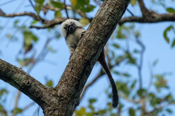
Where to find it: Atlántico, Bolivar, Sucre, Córdoba, Antioquia.

Conservation status: Critically endangered.

Habitat: Found only in the northern region of Colombia in tropical dry forests.

Squirrel-sized, they also have white chests and bellies, while their backs and tails are covered with long black and brown fur. They have claw-like nails, which are essential for jumping from one tree to another.

They feed through the middle layer of the canopy in search of the fruits and insects that make up much of their diet. The Cotton-top tamarin form social family groups that include breeding parents, their adult offspring and even unrelated adults that have migrated into the group.

Interesting Endemic subspecies

Colombian woolly monkey – Lagothrix lagothricha lugens

Where to find it:  Amazonia and Orinoquia Regions.

Conservation status: Critically endangered

Habitat: it can be found in dense forest, fragmented forest and open forest.

It is a large species among the New World monkeys. The body length ranges between 45 and 55 cm, the tail is longer than the body and measures between 60 and 65 cm; the average weight is between 7 to 10 kg, larger males can have a muscular body, with well-developed arms and tails. They are obligate frugivores, completing their diet with immature leaves, their main function in the forest is the dispersion of seeds.

They usually live in groups of 20 to 24 individuals, for their rest periods they look for tall trees to sleep 25 to 30 meters high.

Hernández-Camacho’s Black-mantled Tamarin – Leontocebus nigricollis hernandezi

Where to find it: Amazonas, Caquetá, Cauca, Cauca, Huila, Meta, Nariño, Putumayo

Conservation status: Least concern

Habitat: Found in a wide variety of habitats: secondary vegetation, isolated patches of forest, seasonally flooded forest and inland non-flooded forest up to an altitude of approximately 500 meters above sea level.

Head-body length ranges from 175 to 270 mm, while its tail reaches 250 to 383 mm; it weighs between 338 and 436 g. Females are slightly heavier than females. Females are slightly heavier than males. Their diet is based on insects and fruits.

Colombian squirrel monkey – Saimiri cassiquiarensis albigena

Where to find it:  Amazonia and Upper Orinoco

Conservation status: Least concern

Habitat: It is one of the best known monkeys in Colombia due to its wide distribution, its adaptability to highly disturbed or urban environments.

The body with the head reaches 25 to 37 cm in length in the male and up to 34 cm in the female; the tail is 38 to 45 cm long in the male and up to 43 cm in the female; it weighs between 550 and 1,200 gr.

Their diet is based on insects and ripe fruits, so they spend most of the day moving among the branches in search of food, they are social and arboreal animals, and rarely travel on the ground. Females give birth to 1 or 2 young after a gestation period, which lasts between 150 to 170 days.

Varied Capuchin – Cebus versicolor cesarea

Where to find it:  Cesar, Magdalena, Bolivar, Santander, Boyacá, Caldas, and Cundinamarca.

Conservation status: Critically endangered.

Habitat: it inhabits mosaics of crops with natural spaces, gallery and riparian forest, and dense forest. It is an arboreal and diurnal animal, however, they come down to the ground more often than most New World monkeys.

They feed on many types of food including fruits, plant material, invertebrates and in some cases small vertebrates. They are medium-sized animals weighing between 1.5Kg and 4Kg, with an average adult length between 33.5cm and 45.3cm (excluding the tail), with the male being about 27% larger than the female.

What Can be Done to Conserve Primates in Colombia?

Half of Colombia’s primates are at some level of threat to their survival and little effort is being invested to protect them. This situation is serious, considering the decisions that need to be made for the future of primates, which are an extremely important part of Colombia’s forest ecosystems.

The Atlas of primate biodiversity published by the Humboldt Institute tells us that the loss of the distribution area of endemic primates is a recurrent pattern in the country, some of them have lost between 8 and 68% of their potential and natural distribution.

Avoiding the destruction of forests and minimizing hunting are the main actions that can help their conservation. It is also important to monitor populations and carry out forest restoration projects, generate biological corridors and protect habitat in the most important areas for their populations.

Recently, researchers from the University of Caldas confirmed the presence of a nocturnal monkey in the department of Nariño, which could be a new species. Also in the south of Meta there is a species of marmoset that has a similar appearance to Plecterocebus caquetensis… This means that perhaps in Colombia there are still monkey species to be discovered!.

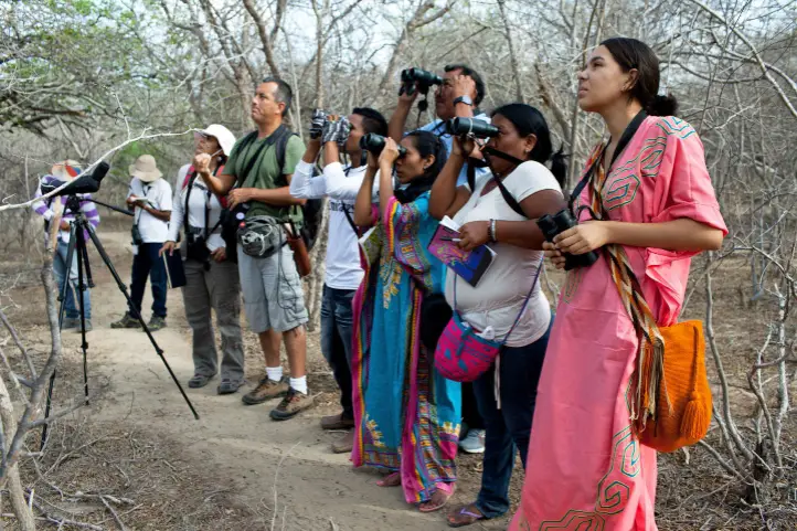
Nature tourism is also a help since it serves as a tool for the education of human populations around the habitats of these species, which they begin to learn about and care for. Learn about Conocer para Conservar initiative in the Primatology Association of Colombia website.

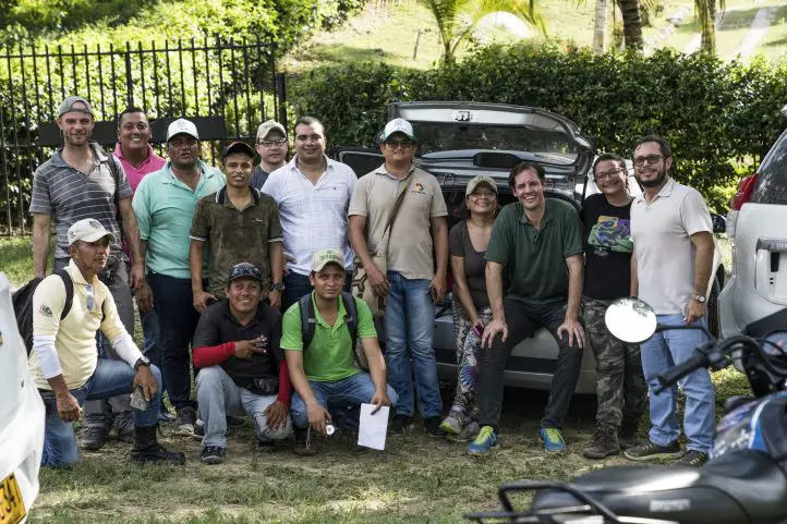
If you want to see monkeys in Colombia, contact us and we will help you plan the best trip!

References
  • http://www.humboldt.org.co/
  • https://www.asoprimatologicacolombiana.org/
  • https://www.itis.gov/
About the authors

Sara Colmenares

The current director of Sula. Doctor in Biological Sciences. Her main interests are to explore and understand the organism-environment interactions, taking advantage of emerging knowledge for the management and conservation of species and ecosystem services. She is currently working as a consultant in functional ecology, ecosystem services, and conservation projects in Colombia related to ecotourism and birdwatching.

Luisa Martin

Engineer, world traveler, amateur photographer, traveling blogger, and foody.

Jaguar Sighting Routes in Colombia and Latin America

The jaguar, yaguar o yaguareté (Panthera onca)  is recognized as the largest feline in America and the third-largest feline after the tiger and the lion. Besides, Colombia is the third country in Latin America with the largest population of jaguars, after Brazil and Peru. So there is a good chance to see them here!

In this publication, you will get the necessary information about jaguars, and where to discover this wonderful species in Colombia.

Facts About Jaguars

  1. Their skin is yellow with rosettes and black spots. However, this species sometimes presents melanic variations: black or dark brown individuals, which are called the black panthers.
  2. The jaguar measures between 1.5 and 2.4 meters, weighs between 45 and 120 kg. and lives between 10 and 12 years. Its body is robust and muscular, with a broad head and small, rounded ears.
  3. Adult jaguars are solitary, only joining temporarily for a couple of weeks for courtship and copulation. The rutting season lasts 12 days in a 47-day cycle. Ovulation in the female is induced by previous copulation, which stimulates and activates the female’s reproductive system.
  4. It is theorized that female jaguars may give birth at any time of the year, but the few reports of cubs generally occur between December and March. Sexual maturity is attained at 24-30 months of age.
  5. Gestation lasts approximately 100 days, and the female gives birth to two or three cubs weighing 800 grams. The cubs are weaned at 4-5 months to begin their carnivorous diet and become independent from their mother between 16 and 24 months of age.
  6. The jaguar has the most powerful bite of all felines, the intensity of the bite in the attack depends on the prey.
  7. Unlike other felines, they do not reject water. In fact, they are very good swimmers.
  8. They are capable of dragging their prey for dozens of meters, even passing it over fallen logs or over wire fences, demonstrating extraordinary strength with their jaws.
  9. The jaguar also plays a fundamental role in the ecosystem balance, it is capable of guaranteeing the survival of smaller species, and it is an excellent protector of water and forests.

Where do the Jaguar live?

Jaguars can be found in diverse habitats such as forests, wetlands, savannas, and grasslands, from sea level to 3,000m altitude. Current jaguar populations are distributed from Mexico to northern Argentina over an area of 8.75 million km2.

In South America, the number of jaguars exceeds 163 thousand, and Brazil and Peru are the countries with the largest populations of this feline.

Despite this broad range, jaguars have been eradicated from 40 percent of their historic range and are extinct in Uruguay and El Salvador. While the rare individual has been spotted in the US, there has not been evidence of a breeding population in the US in more than 50 years.

The Jaguar is an Endangered Species

There are three causes that endanger the jaguar in the different areas through which it moves:

  • The loss of its habitat is due to the use of wildlands for agriculture and other developments. This causes jaguars to run the risk of being isolated in small areas, increasing their risk of extinction.
  • Direct hunting by people living in the countryside, who see the jaguar as a threat to their lives and livelihoods.
  • The scarcity of natural prey, which is also hunted by humans, has led jaguars to reach areas where they encounter domestic animals for food.

According to the IUCN Red List of Threatened Species, of the 34 jaguar subpopulations that exist throughout the continent, 33 are Endangered or Critically Endangered. The Amazonian population is the only one in a state of Least Concern.

Recent studies by Panthera Foundation show that there are about 173,000 jaguars remaining in the Americas, less than half of the species that historically existed throughout its range.

The Jaguar Corridor

The jaguar is listed as “Near Threatened” on the International Union for the Conservation of Nature (IUCN) Red List of Threatened Species, though its status is in review and may be elevated to “Vulnerable” in the next year.

The species is threatened by habitat loss and fragmentation, conflict with local people due to the real or perceived threat posed to livestock, and overhunting of the jaguar’s prey by local people.

The jaguar corridor is a project showing how big predators can indeed live with humans. Dr. Alan Rabinowitz devoted his life to conserving this magnificent cat and co-founded the Panthera organization, “the only organization in the world that is devoted exclusively to the conservation of the world’s 40 wild cat species and their ecosystems”.

Rabinowitz established the world’s first jaguar sanctuary – the Cockscomb Basin Wildlife Sanctuary – in Belize in 1986. He also developed the conceptualization and implementation of the Jaguar Corridor across their entire range from Mexico to Argentina.

Jaguar Corridor and Conservation Areas

The countries that make up the Jaguar Corridor are: Mexico, Belize, Guatemala, Honduras, Honduras, Nicaragua, Costa Rica, Panama, Colombia, Ecuador, Brazil, Argentina, Paraguay, and Bolivia. Besides, the initiative is supported by numerous governments, landowners, corporations, local communities, and scientists.

Currently, the governments of Brazil and Argentina have identified an increase in the jaguar population, which has caused an increase in surveillance and monitoring of border areas in both countries and joint parks to prevent illegal hunters, especially in Iguazu.

Today there is a conservation strategy called Jaguar 2030 Conservation Roadmap for the Americas, a multi-government plan to conserve jaguars across their range supported by UNDP, Panthera, WCS, and WWF. Find out more in the document Jaguar Strategy 2020-2030.

Best Spots to See Jaguars in South America

Jaguars are difficult to spot, as good hunters of prey, they are stealthy animals and camouflage themselves very well. Luck must be on your side!

The most famous destinations for jaguar sightings are:

Brazilian Pantanal.

Jaguars are common to find in the Pantanal ecosystem. 80% of Pantanal is in Brazil, and the remaining 20% is located between Bolivia and Paraguay.

The best spots to see jaguars in Pantanal are in Brazil. In the north, the Cuiabá River is the most known place to watch this animal. Jaguars get exposed during the dry season, from June to October, when they visit the riverbanks to hunt capybara and caiman.

Towards the southern Pantanal, there is the Caiman Lodge, the Onçafari Project fosters ecotourism, monitors wild jaguars, and releases rescued cats into the wild.

The Amazon Jungle in Peru

Manú National Park is a biosphere reserve, a hot spot of biodiversity, where you can see jaguars. Besides, this reserve is a great destination for birdwatching.

The tropical forest of the Guiana Shield in Guyana

The place is famous since the BBC filmed its series Lost Land Of The Jaguar in 2008.

The tropical cloud forest of Belize

In Belize, you will find the first nature reserve created to protect jaguars, it is called Cockscomb, a sanctuary located in central Belize.

Eastern Plains in Colombia

In Casanare, in Hato La Aurora, in Hato Corozal, in the Ariporo and Orinoco River Basin, are the places where jaguars can be free and protected thanks to the support of the community.

In this area there is natural prey such as armadillos, deer, and others that are not found in any habitat, that is to say, that where the Jaguar is, it acts as a protector of these species and those that are not seen such as insects, invertebrates and plants that are within an ecosystem.

Colombia is a favorite place for jaguar conservation

Jaguar populations inhabit forests below 2,000 m.a.s.l., in tropical forests, riparian and gallery forests associated with rivers, marshes and beaches, tropical savannahs; they are also found in montane forests.

In Colombia, there are four blocks of large populations, in decreasing size: Amazon, Orinoco, biogeographic Choco, and the Caribbean. Jaguars’ distribution in the national territory follows like this:

  • 4.2 jaguars per 100 km2 in Amacayacu National Natural Park.
  • 2.8 jaguars per 100 km2 in unprotected Amazonian rainforests.
  • Populations of 3.2 adults/100 km2 for an oil palm landscape in the Magdalena Medio region.
  • 1.9 adults/100 km2 for the Colombian Llanos.

The biological corridor in Colombia covers 228.000 hectares and protects the lives of 34 species of medium and large mammals; it is the most important and largest in the countries where the jaguar is present.

Besides, there are videographic records in different areas of the country where you can see the presence of the jaguar in its natural habitat, which has led to studies for conservation.

Today, Colombia launched its first Jaguar Sighting Route, a conservation – tourism project which aim is to strengthen Colombia as a jaguar sighting destination. The project includes the creation of a guide to good practices for cat watching, training of local guides, and the creation of trails and a portfolio of services associated with nature tourism. Find out more in our entry The Top Post-Covid-19 Destinations for Conservation Lovers in Colombia.

References
  • http://reporte.humboldt.org.co/biodiversidad/2015/cap3/306/#seccion7
  • http://www.wildllanos.com/la-aurora-tour.html
  • https://fundacion-jaguar.org/en/informacion-del-jaguar.php
  • https://www.panthera.org/cms/sites/default/files/Panthera_Fact-Sheet_Jaguar.pdf


About the author

Luisa Martin

Engineer, world traveler, amateur photographer, traveling blogger, and foody.

How Your Visit to Sierra de la Macarena in Colombia Helps for its Conservation?

La Macarena is a municipality located in the department of Meta, Colombia, with natural reserves such as the Sierra de la Macarena Natural National Park which has become internationally known for the seven colors river, Caño Cristales.

The sierra also has petroglyphs of ancient cultures in the Angosturas I and II sectors, in the Guayabero River. There are also enormous waterfalls, such as the Caño Canoas Waterfall, the Yarumales Waterfall, the Mico Waterfall, Soplaculos among others, which are difficult to reach due to the steep terrain.

This region of Colombia has been hard hit by the armed conflict, the planting of illicit crops, extensive cattle ranching and large-scale deforestation. Even after the signing of the peace agreement, it is a territory that continues to undergo a slow process of re-organization of the territory and the role of the people who inhabit it.

Ecotourism and community-based tourism is one of the lines that the local community is developing, taking advantage of the impressive natural wealth of the territory. Plans include the creation of ecological trails where visitors can also participate in the restoration process by planting a tree.

They also want to promote other destinations that activate tourist visits at times other than Caño Cristales, and thus have an income derived from tourism activity throughout the year.

Sierra de la Macarena is a Territory of Great Value for Humanity

The Sierra de La Macarena National Natural Park is located in the department of Meta, in a strategic location where the Andes, the Orinoco Savannah, the Guyanese Shield and the Amazonian plain converge, giving it a hyper mega biodiversity character, a true biological heritage for humanity.

The protected area also connects with the Tinigua and Picachos National Parks.

Sierra de la Macarena

The Sierra de la Macarena is an isolated mountain range that due to its nature, location and type of soil is home to endemic species of flora and fauna, that is to say that only exist in that place. An example of these is the aquatic plant Macarenia clavijera, which gives the reddish, pink and greenish colors to Caño Cristales, the region’s tourist destination par excellence.

Eighty-three percent of the Macarena mountain range is made up of humid forest (tropical humid zone) with an area of 5030 km², in addition to the herbaceous vegetation of the Amazon plain. La Macarena is considered worldwide as one of the most important wildlife refuges on the planet.

Thus, this natural treasure has extraordinary landscapes that are world icons such as the above mentioned Caño Cristales, as well as unique species such as the cumin tree (Aniba perutilis), the jaguar (Panthera onca) and the tapir (Tapirus bairdii).

Sierra de la Macarena National Park, Colombia Picture by Parque Nacionales

Effects of the Armed Conflict and the Peace Process in La Macarena

During the 1970s, the Macarena sector experienced an increase in population due to the fur trade and foreign tourism, but unfortunately, in the 1980s, the logging boom began. Besides that, for more than 40 years La Macarena and surrounding municipalities were occupied by blocks of the former FARC-EP guerrilla and other armed groups in constant conflict.

Guerrilla occupation generated many displacements and a difficult task for the conservation processes of the National Park System and non-profit organizations such as WWF. In fact, no inhabitant could move freely without a mobility permit issued by the FARC.

At the same time, this territory has been the scene of territorial and socio-environmental conflicts related to land ownership, extensive cattle ranching, deforestation, illicit crops, and the presence of armed actors. Despite the efforts and hope brought about by the Peace Agreement, disputes and conflicts in this region were reconfigured and exacerbated after its signing in 2016, increasing the challenges for the conservation of these strategic ecosystems and for peace building in the communities.

Community Actions for Conservation

In the midst of this complex context, some small farmer families living in the Sierra de La Macarena have decided to make a commitment to conservation and are now participating in ecological restoration processes with the production and planting of native tree species, and with ecotourism entrepreneurship.

Tourism appeared as a saving option. Today, in fact, it is for 350 families who live directly from the income generated by this activity. People who work in simple but clean hotels, cooking for tourists, as guides, canoeists, and drivers. Even translators, although so far they only have three who speak English.

Thus, the Ministry of Commerce, Industry and Tourism (MinCit) o Colombia has generated strategies to promote sustainable tourism and support the communities of La Macarena.

Sierra de la Macarena National Natural park

Sierra de la Macarena NNP is in the department of Meta, in the Andean foothills of the Amazon rainforest. In this part of the country, the Andean, Amazonian and Orinoco ecosystems converge, and it has a territorial extension of 10,000 km².

This protected area was created by Decree 1989 of September 1, 1989 and covers an area of 605,793 hectares distributed in 5 municipalities in the southern part of the department of Meta.

The park’s Environmental Management Plan incorporates an ecotourism management plan, which indicates the possible scenarios for this activity. Currently, there are only two characterized scenarios with defined carrying capacity and regulations: Caño Cristales and Raudal Angosturas 1.

Other scenarios have been identified but are not yet regulated for visits, including the La Paz Ecological Trail, the Santo Domingo and Cafetales waterfalls in Mesetas and San Juan de Arama, as well as Raudal II near Puerto Concordia. Thus, these areas cannot be visited because they are still in the process of being organized.

Tourist attractions of Sierra de la Macarena National Natural Park

Today it is possible to visit Caño Cristales with its new trails and the Raudal Angosturas I, thanks to the articulated work that has been carried out since 2014 with the creation of the Mesa Ruta Sierra de la Macarena and the need to expand the supply of ecotourism trails in the Caño Cristales sector, as well as to carry out sufficient technical procedures to implement new ecotourism scenarios that will involve a larger population in the community benefits of tourism in the municipality of La Macarena.

Caño Cristales, the Rainbow River

Cano Cristales, La Macarena, Meta, Colombia.

The Macarena’s most recognized attraction in the area is Caño Cristales, better known as “the river of the five colors”, “the most beautiful river in the world” or “the river that escaped from paradise”; one poet even called it “the rainbow that melted”.

Macarenia clavigera, an aquatic plant endemic to the Macarena, is what allows the river’s crystalline and shallow waters to offer a variety of colors that visitors can appreciate. The extension of the river does not exceed 100 kilometers and has a width of no more than 20 meters, which flows into the Guayabero River. The trails established to learn more about this beautiful place are five circuits of stone and plants, ranging from 3 to 15 kilometers in length.

For more information about Cano Cristales visit our entry Travel Guide to the Rainbow River – Caño Cristales – in Colombia.

Raudal de Angostura I and Ciudad de Piedra

Raudal de Angosturas, La Macarena, Meta, Colombia.

The Raudal Angosturas I destination opened in 2017, as a new ecotourism scenario for the enjoyment of tourists from Colombia and the world. It is a project where you can appreciate the pre-Columbian petroglyphs carved in rocks in low relief that tell the story of the ancestors of the Tinigua tribe when they lived in this area. In turn, Ciudad de Piedra is a trail composed of huge gray rock formations carved over centuries by the force of water.

Many local and national organizations worked together to create this tourist destination, among them, National Natural Parks of Colombia, Cormacarena, the Governor’s Office of Meta, the Mayor’s Office of La Macarena and other members that are part of the Technical Tourism Board: Sierra de la Macarena Route.

Raudal Angosturas I is located between the border of the Sierra de la Macarena and Tinigua National Parks and in the Recovery Zone for Southern Preservation in the municipality of La Macarena, Meta.

This natural wonder contains engraved in its petroglyphs the history of the Tinigua Indians and also the footprint of the armed conflict in Colombia.

The Military Forces of the region support this process of ecotourism management, since it will ensure the safety of those who will enjoy nature tourism in the Macarena Special Management Area.

If you wish to visit the other tourist attractions, you must have a guide specialized in the area, but you must inform the park facilities in the municipality of Granada, Meta.

How to get to Sierra de la Macarena National Natural Park

The following alternatives are the most time efficient, as it is possible to arrive by land but the time will be longer, and probably not safe.

Via Bogotá – La Macarena

Take a 1-hour flight from El Dorado International Airport (BOG) Bogotá to La Macarena Airport (LMC) at La Macarena city with Satena airline. There are also private charter flights that take you there.

Via Cali – Villavicencio – La Macarena

Take a 1-hour flight from Alfonso Bonilla Aragón International Airport in Palmira to Vanguardia Airport (VVC) at La Villavicencio city. Once at the airport, take an approximately 1- hour ride to La Macarena.

What to do in Sierra de la Macarena National Natural Park

Hiking in La Macarena

There are 6 ecotourism trails allowed, which can be done walking or with the help of a horse, and are distributed as follows:

Caño Cristales Ecotourism Scenario, Colors subarea:

  • Salto del Aguila: the number of people allowed daily is 75.
  • Los Pianos: the number of people allowed per day is 62.
  • Caño Escondido: the number of people allowed per day is 37.
  • Intermedio: the number of people allowed per day is 42.

In this scenario you can appreciate the landscape, characteristic vegetation, geological formation, waterfalls, natural pools, aquatic plants (Macarenia clavijera) red, fuchsia and pink; in addition to bird watching.

Scenario Raudal de Angosturas I

  • Ciudad de Piedra: the number of people allowed daily is 37.

In this trail you can do bird watching tour geological formation and rocky outcrop, in addition to the Caño with red plants.

Scenario Mirador Cristalitos

  • Mirador-cristalitos: the number of people allowed daily is 87.

This trail has pictograms, a panoramic view of the convergence of the three ecosystems along its route.

Bear in mind that the trails mentioned above are only authorized by the environmental authorities o the park and may have variations in the routes, which visitors will be informed of when registering. You cannot choose the trail to visit, it is assigned by the authorities and given in order of registration.

Birdwatching at Sierra de la Macarena

There are more than 450 bird species registered in the la Macarena, represented in 65 families, which means that 27% of the Colombian avifauna is present in the park. Dominant bird species are from the Guianas, Amazon and, to a lesser extent, the Andean region.

The following bird species have been recorded from the Amazon: Paroaria gularis gularis, Piaya melanogaster, Electron platyrhynchum pyrrholaemum; from the Andes: Asio flammeus, Trogon personatus personatus, Campephilus pollens, Cistothorus platensis tamae; migratory birds from North America: Anas discors, Pandion haliaetus carolinensis, Actitis macularia, and Coccyzus americanus americanus.

Where to stay in Sierra de la Macarena National Natural Park

Sierra de la Macarena Natural National Park does not currently offer accommodation for travelers, it is possible to stay in La Macarena. Our recommendation of hotels are is La Manigua Lodge, a beautiful ecolodge recently installed in the area. Know more about ecolodges in Colombia in our entry Complete Guide to the Best Eco lodges in Colombia.

Best time to visit Sierra de la Macarena National Natural Park

The main attraction of La Macarena, Caño Cristales, only receives visitors during the winter season, that is, between June and December; for the summer season the community allows the aquatic plants to recover. However, Raudal de Angosturas I is open all year round.

Dry season on the eastern side of La Macarena starts at the beginning of December until late of February at a temperature of 24º C (75 ºF). On the western side the rainfall regime is bimodal, it also has 2 dry periods separated by rainy seasons.

Sierra de la Macarena National Natural Park Entrance fees

The entrance fee varies depending on the nationality and age of the visitors. These are the entrance fees for 2021:

  • Colombians, resident foreigners and tourists from Bolivia, Ecuador and Peru (ages 5 to 25): COP 19,500
  • Colombians, resident foreigners and tourists from Bolivia, Ecuador and Peru (over 25 years old): COP 35,500
  • Non-resident foreigners (over 5 years old): COP 53,500
  • Children under 5 years old and Colombians over 65 years old have free entrance presenting their IDs.

What to consider before visiting Sierra de la Macarena National Natural Park

  • To take any of the tours inside the park you must hire an authorized and certified guide.
  • Consider wearing personal protective items (sunscreen, sunglasses, insect repellent, and hat).
  • The use of flash when taking photographs is prohibited.
  • Use of binoculars to watch animals’ behavior is recommended.
  • Bring along valid identification documents and health insurance.
  • It is recommended to be vaccinated against yellow fever and tetanus.
  • If you take specific medications, take them with you a personal first aid kit.

Some prohibitions

Feeding, bothering or hunting animals, alcoholic drinks and drugs, throwing cigarette butts, burning garbage, felling, and capturing wildlife.

References
About the authors

Sara Colmenares

The current director of Sula. Doctor in Biological Sciences. Her main interests are to explore and understand the organism-environment interactions, taking advantage of emerging knowledge for the management and conservation of species and ecosystem services. She is currently working as a consultant in functional ecology, ecosystem services, and conservation projects in Colombia related to ecotourism and birdwatching.

Luisa Martin

Engineer, world traveler, amateur photographer, traveling blogger, and foody.

Discovering Amacayacu National Natural Park in the Colombian Amazon

Welcome to the land of river dolphins, manatees, anacondas, and the smallest primate in the world: the Amacayacu National Natural Park. The protected forest is home to more than 5,000 species of plants, as well as being the region with the greatest diversity of primates on the planet.

It is the habitat of the Pygmy marmoset (Callithrix pygmaea) the smallest primate in the new world, the largest water lily in the world (Victoria amazonica), the giant silvery-blue butterfly Menelaus blue morpho (Morpho menelaus), and hundreds of more species.

Discovering Amacayacu National Natural Park

Amacayacu National Natural Park protects a strip of jungle in southeastern Colombia in the Amazonas department. This protected area represents 40% of the Amazonian Trapezoid and has a funnel shape, with a total area of 2,935 km².

Amacayacu National Natural Park currently belongs to the municipalities of Leticia, Puerto Nariño, and Tarapacá, in the Amazonas department. The park aims to preserve the most representative samples of tropical rainforest landscapes, flora, and fauna species present in the Amazonian Trapezoid.

Additionally, within the depths of this natural Park located southeast of Puerto Nariño, there are indigenous settlements from the Tikuna ethnicity.

Through the jungle, you will explore swamps, marshes, madre-viejas, and river systems representative of the Amazon rainforest. You will also learn about the Tikuna culture with the help of the guides in the park.

Sunset at the Amazon River

A Little bit of the Tikuna’s History

Between 1630-40, the Cristian missionaries Cristobal de Acuña and Laureano de la Cruz recorded the first registers about the Tikuna natives. The Tikunas were described by them as semi-nomadic people, they avoid contact with foreigners by moving their settlement to inter-fluvial areas within the Amazon jungle.

In the middle of the XVIII century, Tikuna natives were forced to labor during the incursions of the Portuguese colonists who came from Brazil.

At the end of the 19th century, the Tikunas have their own exclusive territory until now. It extends from the Atacuari River up to the current city of Fonte Boa, extending between the bordering countries (Peru and Brazil).

The Role of Community-based Tourism in Amacayacu Park

Most of the human groups present in the park’s area and its zone of influence belong to the Tikuna ethnic group, which is present in Brazil and Colombia. There are also Yagua and Cocama ethnicities, although in smaller numbers, and nowadays, mestizo families.

Indigenous traditions, including the Tikuna, have been strongly affected by the destructive intensity of the gold, rubber, fur, timber, drug trafficking, and mining fevers. All this brought disease, violence, and slavery, among many other situations, detrimental to the local ecosystems and the local people.

Today, indigenous communities look for a balance between traditional and modern life. For this reason, the main subsistence activities for the Tikunas are fishing, agriculture, hunting, ecotourism, handicrafts, research, and monitoring of their natural resources.

Amacayacu Park works together with the local Tikuna community to make community-based ecotourism the best strategy towards sustainability and to counteract the natural resource extraction activities.

How to get to Amacayacu National Natural Park

Firstly you must flight to Leticia, the capital of the Amazonas department in Colombia. The most popular route is from Bogota with Avianca, LATAM, and Satena airlines.

The flight takes a 1,5-hours flight from Bogotá to General Alfredo Vásquez Cobo International Airport (LET) at Leticia city.

Once at the airport, you have to go to Leticia Fluvial Port, an approximately 30- minutes ride. Once at the Port you should take an extra 1,5 hours boat ride to Puerto Nariño.

The schedule offered by the 3 companies providing services begins at 8:00 am, 10:00 am, and 1:30 pm. For the return, the schedule starts at 7:30 am, 11:00 am, and 3:30 pm.

It is possible to book your own schedule by hiring private operators, but costs may increase with respect to the already established schedules.

What to do in Amacayacu National Natural Park

The park is currently closed to the public due to the Pandemic situation. The indigenous people of Mocagua and San Martin offer the following activities:

Hiking

There are four different trails: Las Chagras, Selva, Acuaticos and Miquiando.

  • Chagras Trail: On the trail, you can appreciate the crops used by locals and production techniques.
  • Selva (Jungle) Trail: A tour through the Amazon jungle to appreciate the most diverse number of Amazon’s plants and animals, such as primates, mammals, and a great variety of birds.
  • Aquatic (Aquatic) Trail: Diurnal or nocturals tours that cross the Amacayacu River and the Matamata Creek. In these tours, you can appreciate the different aquatic mammals such as the so-called pink dolphins or Amazon river dolphin (Inia geoffrensis) and the Amazonian manatee (Trichechus inunguis).
  • Miquiando (Monkey) Trail: In the Mocagua indigenous reserve, the Maikuchiga Foundation offers a tour where you can learn about the 9 species of primates present in this part of the Amazonian trapeze. In the foundation, there are specimens that have been rescued from illegal trafficking.

Birdwatching

More than 468 birds have been registered in the Amacayacu park, representing almost a third of the country’s bird population. Among the most outstanding birds are the Hoatzin (Opisthocomus hoazin), Wattled curassow (Crax globulosa), Razor-billed curassow (Mitu tuberosum), and Grey-winged Trumpeter (Psophia crepitans capensis).

Wildlife tours

Amazon river dolphin (Inia geoffrensis), also known as the boto, bufeo or pink river dolphin

More than 150 different kinds of mammals have been recorded to inhabit this area. Three of the four species of freshwater aquatic mammals existing in Colombia can be found in the park:

Other interesting animals include:

  • Pygmy marmoset (Callithrix pygmaea)
  • Brown woolly monkey (Lagothrix lagotricha)
  • Anaconda (Eunectes murinus)
  • Matamata turtle (Chelus fimbriata)

Where to stay in Amacayacu National Natural Park

Currently, the Amacayacu Natural National Park does not offer accommodation for travelers due to its closure. You can stay in Leticia or in Puerto Nariño. We recommend you to stay in La Ceiba and Decameron Decalodge Ticuna in Leticia, Cabañas Maikü Selva in Puerto Nariño.

Best time to visit Amacayacu National Natural Park

Amacayacu can be visited all year round, there is no dry season but July is the month with the least amount of rainfall and a temperature of 26º C (97 ºF).

Amacayacu National Natural Park Entrance fees

The park is currently closed, so there is no entrance fee. Possible costs vary depending on the services provided in Mocagua and San Martin.

What to Consider Before Visiting Amacayacu National Natural Park

  • To take any of the tours inside the park you must hire an authorized and certified guide.
  • Consider wearing personal protective items (sunscreen, sunglasses, towel, insect repellent, and hat).
  • Use binoculars to watch animals’ behavior.
  • Bring along valid identification documents and health insurance.
  • Be vaccinated against yellow fever and tetanus.
  • If you take specific medications, take them with you in a personal first aid kit.

Some prohibitions

Feeding, bothering, or hunting animals, alcoholic drinks and drugs, throwing cigarette butts, burning garbage, felling, and capturing wildlife.

References
  • Colparques
  • SINAP
  • Colombia travel
About the authors

Luisa Martin

Engineer, world traveler, amateur photographer, traveling blogger, and foody.

Sara Colmenares

The current director of Sula. Doctor in Biological Sciences. Her main interests are to explore and understand the organism-environment interactions, taking advantage of emerging knowledge for the management and conservation of species and ecosystem services. She is currently working as a consultant in functional ecology, ecosystem services, and conservation projects in Colombia related to ecotourism and birdwatching.

Why You Should Visit Uramba Bahía Málaga National Natural Park in Colombia?

The answer is simple! If you like nature and also like to support community-based tourism activities, Uramba Bahía Málaga is a destination for you: It is a worldwide recognized biodiversity hotspot, you can see humpback whales there, and you will be helping an Afro-descendant community that bet on ecotourism as a new way for the development of its territory.

Uramba Bahía Málaga is the 56th National Natural Park declared in Colombia and is located in one of the most biodiverse places on the planet: the Biogeographic Choco, in the Pacific Region.

This wonderful and highly pristine place is considered a hot spot for nature conservation worldwide. The calm waters of Uramba Bahía Málaga National Natural Park are the preferred place for the birth and breeding of humpback whales, making this place even more special.

You can’t miss the chance to visit Bahia Malaga in Colombia. This 100% marine area contributes to increasing the representativeness of marine ecosystems in the National System of Protected Areas – SINAP- and also strengthens the socio-cultural dynamics of the afro communities living in the area through community-based ecotourism.

Discovering Uramba Bahía Málaga National Natural Park

This protected area is located in the Pacific Coastal Region in the southwest of Colombia. The park has an extension of approximately 479.94 km² of the marine surface.

The marine waters near Bahia Malaga are considered the migratory route of humpback whales, or yubartas, (Megaptera novaeangliae). This place of calm and deep waters is annually visited by more than 500 yubarta whales from Antarctica, that come to mate and raise their calves between the months of July to October.

The Socio-Cultural Importance in the Uramba Bahía Málaga Territory

Uramba Bahia Malaga is a name of African origin, which means Minga, or group. This name arose due to the particular way in which this protected area was created.

This National Natural Park born as a joint effort between the local communities that live there and the government, the latter through the National Park System. Additionally, the park is under the surveillance of the Colombian Navy.

The afro-community councils present in Bahia Malaga are:

  • Juanchaco,
  • Ladrilleros,
  • La Barra,
  • La Plata – Bahía Málaga, and
  • Puerto España – Miramar.

This important conservation unit seeks to conserve the marine and coastal ecosystems of Bahia Malaga and to strengthen the cultural dynamics and social organization for the management of the territory based on the knowledge and ancestral wisdom of the black communities that live there.

La Barra Beach, Ladrilleros, Colombia

Commercial Port or Natural Park?

But, despite the enormous natural and cultural wealth of the region, there was also the intention to turn this bay into a huge multifunctional commercial port.

Fortunately, the local community was convinced to apply alternative economic development options such as nature and cultural tourism; as well as their own conscious and responsible relationship with the territory, as their cultural practices have contributed substantially to the conservation of the area.

Thus, this reserve is the first in Colombia where community-based tourism plays a central role, and it is administered by the Afro-descendant community councils that exist in the region and the national park system. It is the first joint administration proposal in Colombia.

Thus, after much debate and argumentation from both sides, in August 2010, this area was officially declared as protected.

According to WWF:

The communities settled in Bahía Málaga affirm that the area is not only important for its biodiversity but also for its cultural richness. Black communities and indigenous peoples present in the area have achieved an important degree of social organization in their ancestral relationship with the territory, and their cultural practices have contributed substantially to the conservation of their ecosystems. In this sense, declaring Malaga a protected area serves a dual environmental and sociocultural purpose.

Uramba Bahía Málaga Biodiversity

The Uramba Bahia Malaga Park is home to an immense diversity of continental and marine flora and fauna species and has been identified as one of the priority conservation sites in the Colombian Pacific.

The humpback whale (Megaptera novaeangliae)

The marine and coastal ecosystems of Bahía Málaga represent the Colombian Pacific and are a fundamental scenario for the reproduction and breeding of the Humpback Whale and the perpetuation of wild species of seabirds and shorebirds, sea turtles, estuarine and marine fish, and crustaceans.

The annual arrival of humpback whales is its main attraction. However, the beauty and diversity of the landscapes of Bahía Málaga and its area of influence are also ideal to enjoy nature.

The park has diverse ecosystems such as very humid tropical forests, beaches, cliffs, islands, estuaries, and bodies of water with soft and rocky seabeds.

How to get to Uramba Bahía Málaga National Natural Park

Uramba Bahía Málaga National Natural Park is in the middle portion of the Colombian Pacific coast, in the District of Buenaventura, in the department of Valle del Cauca. There are two options to access the Park from Bogota:

Bogota – Buenaventura

First you make a Bogota-Buenaventura trip by air, with 1h 15m duration. There are 2 flights per week with Satena airlines. Then you must make the transfer Buenaventura-Juanchaco by sea, which takes 1 hour and is done in a speedboat.

Bogota – Cali

Travel from Bogota to Cali by air or land. Once in Cali, you have to travel to Buenaventura by land. Finally, take the maritime route from Buenaventura to Juanchaco, which takes 1 hour and is done by speedboat.

What to do in Uramba Bahía Málaga National Natural Park

We recommend you plan your visit to stay for at least 3 days and 4 nights. Especially because of the long trip by road and then by boat. This is not a one-day stay destination.

Unfortunately, the visit to the Uramba Bahía Málaga National Natural Park has been suspended due to the health emergency that the country is facing because of covid-19.

Hiking, Canoeing, and Kayaking

Enjoying the beautiful Pacific landscape by doing hiking is a great experience. In the park’s area of influence, there are hiking and canoeing activities through the mangroves.

Although there are no defined aquatic trails in the bay area, it is suggested to follow the internal circuits to visit the route of the piangua, ostional, the waterfall of La Sierpe and Tres Marías in the sector of La Plata, Playa Chucheros, Juán de Dios, the beaches of La Barra sector, Juanchaco and Ladrilleros cliffs and their natural pools.

Kayaking through mangroves is highly recommended, also canoeing to Isla Plata, which is not the most exciting but still worth the try.

Birdwatching

Bird watching is a potential ecotourism activity in the park, but it is not well-developed. The park has a record of 107 species of birds, being an important point in the reproduction of marine birds.

Wildlife

Despite the huge marine and terrestrial diversity in the park, the main attraction is humpback whale watching. Thus, activities such as diving or snorkeling are not offered.

Humpback whale watching is an activity addressed by young natives from the local communities, who act as environmental interpreters.

During the whale season, the highest density of whales is between the months of September and October.

If you visit the Uramba Bahia Malaga park for a whale watching tour you should keep in mind that:

  • You will receive a 10-minute induction on the importance of the area and the significance of the role it plays in ecological processes such as reproduction, calving, breeding, nursing, socialization.
  • You must take a boat that carries a flag or a sighting authorization badge. The first trips leave at 8 am.
  • All boats must be accompanied by a community environmental interpreter.
  • The defined whale watching period is between July 15 and October 15.
  • Whale watching time for each group should be in the range of 15 to 30 minutes.
  • The approach to the whales should be slow, parallel, and always from behind.
  • The boat should maintain 200 meters from the individuals, so do not ask to get too close.
  • Avoid following the females with their calves.
  • You must be patient as only up to 5 small boats are allowed per group of whales. Also, you cannot be in a hurry, as the motors will always be neutral.

Where to stay in Uramba Bahía Málaga National Natural Park

The park does not offer accommodation, therefore our recommended options for you to stay are:

Lodging at La Barra Beach

Coco House Hotel; Casa Majagua and Vista al Mar Hotel.

Lodging at Ladrilleros Beach

Hotel Zully, Hotel Villa Cindy, and Hotel Reserva Agua Marina.

Best time to visit Uramba Bahía Málaga National Natural Park

The park can be visited all year round. The dry season starts at the beginning of June until late September and from the beginning of December until late February. In addition, whale season starts from July to October.

Uramba Bahía Málaga National Natural Park Entrance fees

Currently, no fees apply.

What to consider before visiting Uramba Bahía Málaga National Natural Park

  • To take any of the tours inside the park you must hire an authorized and certified guide.
  • Consider wearing personal protective items (sunscreen, sunglasses, towel, insect repellent, and hat).
  • We recommend the use of binoculars to admire animals’ behavior and beauty in their natural habitat.
  • Carry valid identity documents and health insurance.
  • Be vaccinated against yellow fever and tetanus.
  • If you take specific medications, take them with you in a personal first aid kit.

Some prohibitions

Feeding, bothering, or hunting animals, alcoholic drinks and drugs, littering, burning garbage, felling, and capturing wildlife.

References
  • Colparques
  • National Parks Systems
  • bahiamalaga.org
About the authors

Luisa Martin

Engineer, world traveler, amateur photographer, traveling blogger, and foody.

Sara Colmenares

The current director of Sula. Doctor in Biological Sciences. Her main interests are to explore and understand the organism-environment interactions, taking advantage of emerging knowledge for the management and conservation of species and ecosystem services. She is currently working as a consultant in functional ecology, ecosystem services, and conservation projects in Colombia related to ecotourism and birdwatching.

Best Place for Diving in Colombia: Malpelo Island Flora and Fauna Sanctuary

On the Pacific Ocean, 507 km west of the port of Buenaventura, is the island of Malpelo. It is the only oceanic island of the Pacific Ocean and belongs to the marine corridor of the eastern Pacific Ocean with 11 emerged islets.

The charm of Malpelo lies beneath the surface of the sea. Thanks to its location and great variety of marine flora and fauna Malpelo is among the 5 most beautiful and exotic places in the world to practice scuba diving.

The characteristics of the marine environment are strongly influenced by the type of currents that run through this area of the Pacific. Malpelo is the point of confluence of different and important currents of the Pacific Ocean. 

The encounter between the cold currents of the southern hemisphere and the warm equatorial currents makes its waters very rich in nutrients. Because of this, Malpelo is home to an incredible amount of fauna: hundreds of Green Moray Eels that swim in open waters, schools of barracudas, turtles, dolphins, manta rays in solitary and in groups, rays, longfins, and huge schools of mackerels.

Malpelo is also the sharks paradise, and this is the main reason that makes Malpelo a unique place in the world, with large concentrations of Silky Sharks (Carcharhinus falciformis) and Hammerhead Sharks (Sphyrna lewini), among others.

Discovering Malpelo Flora and Fauna Sanctuary

The Malpelo Flora and Fauna Sanctuary is located on the unique submarine volcanic mountain range, Dorsal de Malpelo. The highest point is Cerro la Mona 300 meters above sea level, this marine mountain range has a length of 150 miles and 50 miles wide.

Voluminous eruptions of basaltic lava gave birth to this island. The islets that surround the island seem to be the result of erosion processes caused by the waves, causing them to be lifted by tectonic effects. This process forms terraces known as “Strath Terraces”.

Malpelo Flora and Fauna Sanctuary was declared a protected area in 1995 and has had 3 expansions in the years 1996, 2006 and 2017 with a total of 1.7 million miles.

In 2005 it was named an Important Bird Conservation Area (IBA) by BirdLife International and the Alexander Von Humboldt Research Institute. In 2006, UNESCO declared the sanctuary a Natural World Heritage Site, and today it is a Mission Blue hotspot. 

Malpelo Flora and Fauna Sanctuary has one of the most important coral formations of the Colombian Pacific; the marine fauna is very varied on the island, and in this sanctuary you can find 2 species of starfish endemic to the country. In addition to this, one of the most important hammerhead shark breeding areas in the world is located in Malpelo Flora and Fauna Sanctuary.

Unfortunately, the sanctuary is constantly harassed by illegal fishermen, which mainly affects hammerhead sharks and hawksbill turtles. In addition, overfishing in zones of influence within the protected area’s limits, such as for tuna, can reach alarming numbers, endangering the decline of the tuna communities.

The Malpelo y Otros Ecosistemas Marinos Foundation, is in charge of promoting the protection and care of marine areas, especially sharks, so that they have a safe habitat for their reproduction. They work together with the national parks system and the national navy.

How to get to Malpelo Flora and Fauna Sanctuary

Bogotá-Buenaventura

The only way to access the sanctuary is by sea, after a 36-hours open sea journey from the city of Buenaventura. Take a 145- minutes flight from Bogotá to Alfonso Bonilla Aragón International Airport (CLO) at Palmira city. Once at the airport, take an approximately 3- hours ride to Buenaventura.

What to do in Malpelo Flora and Fauna Sanctuary

Diving and snorkeling

The sanctuary has the following areas for these activities: La gringa, Escuba, Los Reyes, Los gemelos, Sahara, Vagamares, El arrecife, La nevera, Monster face, El mirador, El Freezer, Aquarium, Naufragio wall, Bajo del ancla and Bajo del Monstruo.

These areas have the optimal conditions for a unique experience. You must keep in mind that if you want to do these activities you must have previous knowledge.

Wildlife

The biological component in the terrestrial environment of Malpelo Island is represented by algae, lichens, mosses, some grasses, shrubby legumes and ferns. Seabirds provide guano that acts as fertilizer along with the rain to generate a food source for the invertebrates that inhabit the island.

Ants such as the trap jaw ants (Odontomachus baur), which is considered to have been introduced to the island by man, can be found throughout the sanctuary. It is also possible to find a new species of beetle from the Platynus genus, which is unusual and can be found in Colombia and Ecuador.

Johngarthia malpilensis – Ph. by Daniel Vásquez-Restrepo CC

On the island, it is also possible to observe the terrestrial crab Johngarthia malpilensis, which is also endemic to the island. Besides this, several other species of crabs also live on the hard substrates, and there are around 270 species of gastropods, 60 of bivalves, 3 of cephalopods, 2 of Scaphopods, and 6 of Polyplacophorans.

Four species of reptiles inhabit the sanctuary:

  • Anolis agassizi, from the equator, feeds on the remains and food waste of seabirds.
  • Dactyloa agassizi is one of the island’s endemic lizards, greenish in color. It feeds on insects and crabs.
  • Diploglossus millepunctatus is also an endemic lizard of the island. Its diet is based on the remains of seabirds and in case of food shortages they can break their eggs and consume them together with the dead hatchlings.
  • Phyllodactus traversalis, known as the geko lizard, joins the sanctuary’s endemic species. It has nocturnal feeding habits based on insects, but during the day it takes refuge in rock crevices.

Malpelo has a wide variety of marine birds, making it an excellent place for bird watching. The bird with the largest representation is the Nazca booby (Sula granti). A third to a quarter of the total breeding population of this species worldwide nests in the Island of Malpelo.

The Biological Component in the Marine Environment

You will see different specie in the rocky walls of Malpelo depending on the depth. From 3 to 6 meters the walls are covered by sponges and some corals, such as the Tubastrea aurea. After 27 meters it is possible to see filamentous algae and violet hydro corals.

In the depths of the sanctuary there are submarine terraces divided into 4 sectors; the slopes of these sectors are the areas where the coral communities are most present. The four sectors are located as follows:

  • “El Arrecife”, it is the most extensive and is located to the northeast of the island.
  • “Pared del Náufrago” (Castaway’s Wall), located to the northwest.
  • “La Bahía de la Nevera” to the west, and “El Bajo de la Nevera” to the southwest.
  • “El Bajo de Junior” to the southwest.
Whale shark (Rhincodon typus) CC Ph. By Sandra Bessudo, Malpelo Foundation

The sanctuary has identified 390 reef fish species and 5 of these species are endemic: Halichoeres malpelo, Axoclinus rubinoffi, Lepidonectes bimaculta, Chriolepis lepidotus, and Acanthemblemaria stephensi.

Pelagic fish, mammals, and sea turtles aggregate in the sanctuary, and it is considered a passageway for migratory species such as tuna, which feed in the sanctuary’s environment during their migration.

There are two species of sharks that can be seen during the visit: hammerhead shark (Sphyrna lewini) and Galapagos shark (Carcharhinus galapagensis). The cleaning zones in Malpelo are inhabited by the barberfish (Jhonrandallia nigrirostris), the king angelfish (Holacanthus passer) and juveniles of mexican hogfish (Bodianus diplotaenia).

Due to the large number of larvae present in the sanctuary, it is possible to see whale sharks (Rhincodon typus) and manta rays (Manta birostris), which can be frequently sighted along with communities of common bottlenose dolphins (Tursiops truncatus).

Where to stay in Malpelo Flora and Fauna Sanctuary

Malpelo Flora and Fauna Sanctuary does not have lodging available, you will stay on boat.

Best time to visit Malpelo Flora and Fauna Sanctuary

Malpelo Island can be visited all year round, it has humidity in the air and remains covered by a dense mist. The months with the lowest humidity are between December and March.

Malpelo Flora and Fauna Sanctuary Entrance fees

The entrance fee varies depending on the nationality and age of the visitors. These are the entrance fees for 2021:

  • Colombians, foreigners holding a valid residence permit, and tourists from Bolivia, Ecuador and Peru (over 25 years old): COP 116.000 (Diver/day); COP 79.000 (Instructors for accompanying groups/day): COP 35.500 (Boats/day)
  • Non-resident foreigners (over 25 years old): COP 216.000 (Diver/day); COP 116.000 (Instructors for accompanying groups/day): COP 65.000 (Boats/day)

What to consider before visiting Malpelo Flora and Fauna Sanctuary

  • To dive in Malpelo there must be one certified guide with experience in the area for every six divers.
  • Tourists must be certified as advanced divers or two-star divers, and have a minimum of 35 dives in their logbook, information that will be corroborated by the National Parks official in the protected area.
  • The maximum diving depth allowed is up to 140 feet.
  • Each diver must have the minimum equipment for underwater activities and safety equipment.
  • Minors must have written permission from their parents, even if they are accompanying them.
  • It is important to ensure buoyancy control as a measure to avoid damage to ecosystems, and to refrain from feeding, chasing or touching marine fauna. Therefore, a buoyancy check dive is done to verify the diver’s ability.
  • Avoid carrying harmful elements that threaten the health of ecosystems such as CFC aerosols, and non-biodegradable cleaning products.
  • Diving activities are programmed from 8:00 a.m. to 5:00 p.m., all within a previously defined schedule and depending on weather and oceanographic conditions.
  • Recommended the use of binoculars to admire animals’ behavior and beauty in their natural habitat.
  • Carry valid identity documents and health insurance. It is recommended to be vaccinated against yellow fever and tetanus.
  • If you take specific medications, take them with you.

Some prohibitions

Feeding, bothering or hunting animals, alcoholic drinks and drugs, throwing cigarette butts, burning garbage, felling, and capturing wildlife.

If you want to plan your trip to Colombia do not hesitate to contact us, visit our Plan your trip page!

References
About the authors

Luisa Martin

Engineer, world traveler, amateur photographer, traveling blogger, and foody.

Sara Colmenares

The current director of Sula. Doctor in Biological Sciences. Her main interests are to explore and understand the organism–environment interactions, taking advantage of emerging knowledge for the management and conservation of species and ecosystem services. She is currently working as a consultant in functional ecology, ecosystem services, and conservation projects in Colombia related to ecotourism and birdwatching.

Best places to see Anteaters in Colombia

The terror of ants and termites also lives in Colombia. They are creatures with a docile character and poses no threat to man. On a tailored wildlife holiday with SULA, you have a good chance to see anteaters in Colombia, such as the Giant Anteater (Myrmecophaga tridactyla) and the Tamandua, or lesser anteater (Tamandua tetradactyla). They can often be found in savannas, and open grasslands, where the termites upon which they feed are abundant.

The Anteaters

The South American anteater is an animal that has a tongue similar to that of a long worm, which is why it is classified in the suborder Vermilingua, which literally means “worm tongue”. The anteaters are predators specialized in eating insects, especially ants and termites.

Anteaters are distant cousin of sloths and armadillos, and contrary to what you may think, they have nothing to do with aardvarks, numbats, echidnas, pangolins, and some spiders, which are also called anteaters.

Anteaters are endangered species, rice crops, African palm plantations, and livestock are the main causes of displacement of the anteater from its natural habitat. Forced displacement affects their diet and their reproduction rates decrease; in addition, anteaters may be run over by vehicles or face other problems with humans.

Ecotourism is a source of income to promote their study and conservation.

Anteaters Species

There are four species of anteaters still alive: the silky anteater (Cyclopes didactylus), the giant anteater (Myrmecophaga tridactyla), the northern tamandua (Tamandua mexicana) and the southern tamandua (Tamandua tetradactyla).

Silky anteater – Cyclopes didactylus © Tinka Plese – Rojano, C., Miranda, L., Ávila, R. (Editores). 2014. Manual de Rehabilitación de Hormigueros de Colombia. Fundación Cunaguaro, Geopark
Colombia S.A.S. El Yopal, Casanare. 155 p
Anteaters in Colombia, in this picture the Giant anteater –Myrmecophaga tridactyla
Southern tamandua – Tamandua tetradactyla © M.Tello Rojano, C., Miranda, L., Ávila, R. (Editores). 2014. Manual de Rehabilitación de Hormigueros de Colombia. Fundación Cunaguaro, Geopark Colombia S.A.S. El Yopal, Casanare. 155 p

The difference between them lies mainly in the habitat in which they live, which includes tropical dry forests, rainforests, grasslands and savannas, although not in the Andean mountainous regions. The giant anteater lives in savannas. And that is where they can be found in Colombia.

As for the two anteaters of the genus Tamandua, and the silky anteater, they are much smaller than the giant anteater, their fur is yellowish, and they live in trees.

The Wold Anteater Day is celebrated on 29 November every year, reminding the importance of their conservation.

Where do Anteaters Live

Originally, these animals were exclusive to South America, but once the isthmus of Panama was formed about three million years ago, anteaters expanded their range to Central America.

Thus, giant anteaters can be found as far as Central America, while silky anteaters and northern tamanduas reach as far as Mexico. Southern tamanduas extend as far south as Uruguay.

There are several names for anteaters in south America, and they depend on the species. The giant anteater is called ant bear, “oso hormiguero” in Spanish, the silky anteater is also known as pygmy anteater, and for the tamanduas there are names such as tamanduá, guazú, yautare, kuarevachú, Oso Bandera, and Oso Palmero.

Where You Can Find the Anteater

Anteaters are widely distributed in South America and can be found in the following countries:

  • Argentina (Provinces of Formosa, Chaco, Misiones and Salta)
  • Bolivia
  • Brazil
  • Colombia
  • Costa Rica
  • Ecuador
  • Honduras
  • Nicaragua
  • Peru
  • Paraguay
  • Venezuela

7 Facts about Anteaters you cannot miss

  1. Anteaters can swallow a total of 35,000 ants and/or termites per day.
  2. The anteater tongue flicks 150 times per minute, and has thousands of tiny hooks and large amounts of saliva to eat ants or termites from trees and mounds.
  3. The anteater’s stomach is similar to a bird’s gizzard, using small amounts of sand and dirt to digest insects.
  4. Unlike other mammals, Anteaters don’t have teeth.
  5. Anteaters have a disgusting smell to defend themselves from their biggest predators, Puma and Jaguar, they also have long arched claws on their strong legs that may cause fatal injuries.
  6. Female gestation is of approximately 190 days. After birth, offspring are carried at the female’s back for 2 years, camouflaging themselves in the mother’s fur.
  7. They are one of the most ecological animals on the planet. Despite the large number of ants they consume, anteaters are very careful when eating and do not destroy the habitat of ants and/or termites.

Myths and Legends around the Anteaters

The anteater is perceived as a strange looking animal although it is viewed sympathetically and fortunately without culinary objectives. Its rarity and vulnerability, being so specialized in its feeding, promote it as a symbol of conservation, and also as a great attraction for nature tourism.

The anteater appears in several South American legends and stories, both indigenous and Creole. One of the most attractive is the one compiled by the writer Graciela Repún, which comes from the Kaingangá Indians of the jungle of Misiones (Argentina).

It seems that after the great flood, Kadjurukré, their creator god, worked at night to model with mud the animals of the jungle and when he was trying to finish the anteater, in a hurry because the sun was rising, he took a stick and put it in his mouth as a tongue because he did not have enough time to put teeth. And so he sent it to eat ants….

Where to See Anteaters in Colombia

The geographical distribution anteaters in Colombia is extensive. However, despite the wide distribution of anteaters in Colombia, the best place to watch them is in the Eastern Plains of Colombia.

There are several places to go in a Safari where it is possible to find these animals hanging around the savannas or the riparian forests. The best time to see the anteater is dry season between December and late March.

Here in SULA we offer a Safari that goes through Casanare an Meta departments, in the eastern plains of Colombia, where anteaters and other species present in this region can be spotted.

Casanare

Safari in Casanare

The conservation, education and research work of the Yopal-based environmental organization Fundación Cunaguaro includes anteaters. That includes monitoring the absurd number of road killings of these creatures – 400 giant anteaters a year and at least 1,500 tamanduas.

The foundation promotes ecotourism on large private estates, from where you can go out in search of the anteaters in Colombia.

El Encanto de Guanapalo

It is a group of cattle ranches which covers 9,000 hectares of inundable savannah and acts as a strategic wildlife corridor. El Encanto de Guanapalo Natural Reserve is conformed by 3 haciendas with a total area of 90 square kilometers, you can have a typical experience of the eastern plains, along with the conservation of the flora and fauna of the sector.

Wild horses and termite mounds at Casanare’s savannas.

Corocora Camp

Corocora Camp, Casanare, Colombia

Corocora Camp, the first luxury safari camp in Colombia. It is located two and a half hours from the Yopal airport by 4×4 vehicle. There you will find five large beige canvas tents, identical to those of the high-flying African safaris.

La Palmita Reserve

The municipality of Trinidad hosts La Palmita nature reserve, which has a research center that is responsible for acquiring knowledge of the biological and social diversity of the Orinoquia region for its conservation.

Meta

Find out more information about Meta anteaters destinations in our entry #1 Llanos Experience near to Bogotá: The Llanero Dawn Route in Meta.

Lagos de Menegua

Lagos de Menegua Hotel & Bioreserve

Mururito Nature Reserve

@Colombiafrank at Mururito

Recommendations for your visit

  • Take yellow fever and tetanus vaccines shot prior to arrival.
  • Do not forget that mosquito repellent is highly recommended.
  • Bring rubber boots, a raincoat, long-sleeved shirts, sunscreen.
  • Leave no trace.
  • Carry valid identity documents and health insurance.
  • If you take specific medications, take them with you.
  • It’s never too much to carry a personal medicine kit.

If you want to plan your trip to Colombia do not hesitate to contact us, visit our Plan your trip page!

References
About the authors

Sara Colmenares

The current director of Sula. Doctor in Biological Sciences. Her main interests are to explore and understand the organism–environment interactions, taking advantage of emerging knowledge for the management and conservation of species and ecosystem services. She is currently working as a consultant in functional ecology, ecosystem services, and conservation projects in Colombia related to ecotourism and birdwatching.

Luisa Martin

Engineer, world traveler, amateur photographer, traveling blogger, and foody.

Bird-watching Tourism Helps to Reduce Bird Extinction Risks in Colombia


Extinction is the disappearance of all members of a species. Extinction is considered from the instant in which the last individual of a species dies.

Colombia is a megadiverse country, with a natural wealth that for a long time was hidden by the shadow of war. Recent scientific expeditions, such as Colombia Bio, have shown how little we knew about our fauna and flora, so much so that with each of them new species have been discovered.

Colombia bio ©Colciencias

However, the expeditions also left the question of how much we may not have known. We are now in a race against indiscriminate and poorly controlled human intervention.

Deforestation, expansion of the agricultural frontier, mining, illicit crops are now present in these previously unexplored territories.

Tourism still needs to make its way into these regions as a competitive and profitable alternative. At the same time, as a good strategy for biodiversity conservation.

International Union for Conservation of Nature, UICN

The UICN is an organization whose mission is to influence, encourage and assist societies to conserve the integrity and diversity of nature and to ensure that any use of natural resources is equitable and ecologically sustainable.

IUCN has been active for more than 70 years, and today works in a combined effort to conserve nature and accelerate the transition to sustainable development.

IUCN has developed a comprehensive information system on the conservation status of animal, fungal and plant species worldwide: The IUCN Red List.

The IUCN Red List Categories and Criteria

The IUCN Red List Categories and Criteria is a system for classifying the risk of extinction of species worldwide. It divides species into nine categories:

  • Not Evaluated, NE.
  • Data Deficient, DD.
  • Least Concern, LC.
  • Near Threatened, NT.
  • Vulnerable, VU.
  • Endangered, EN.
  • Critically Endangered, CR.
  • Extinct in the Wild, EW.
  • Extinct, EX.

Species may move up or down the list as their populations increase or decline. Find more information at the UICN Red List website iucnredlist.org.

Bird Extinction

Painting of a dodo head by Cornelis Saftleven from 1638, probably the latest original depiction of the species ©Cornelis Saftleven – History of the dodo. http://julianhume.co.uk/

According to Colombia Birdfair, 40% of the bird species that inhabit our planet are going through a population decline, and 1 in 8 species is threatened. In addition to this, 1.4% have become extinct.

Here you will find some data:

Human activities are the main factor related with bird extinction. Climate change, intensive agriculture, invasive species, illegal hunting and overfishing are behind this devastating statistic.

First Bird Extinct in Colombia

The only bird species known to be extinct in Colombia is the Colombian GrebePodiceps andinus, endemic to the wetlands in the Eastern Andes of Colombia.  It was last recorded in 1977 in Lake Tota. 

Podiceps andinus ©Paula Andrea Romero, Arte&Conservación – BirdsColombia

Its disappearance is associated with the combined result of wetland drainage, and the eutrophication and salinization that has destroyed the submerged Potamogeton vegetation, where this species fed on a great variety of arthropods. 

Additional extinction factors were the introduction of exotic fish, such as the rainbow trout Salmo gairdneri (Fjeldså 1993), hunting, pesticide pollutionremoval of reeds, and predation. 

Bogota Rail – Rallus semiplumbeus, EN. ©neilorlandodiazma CC BY-SA 2.0.

According to the Humedales de Bogotá Foundation, the extinction of the Colombian Grebe should be remembered, and should serve as a lesson. 

Currently, there are two species of birds endemic to the Bogotá Savanna in critical danger of extinction, the Bogota Rail (Rallus semiplumbeus) and the Apolinar’s Wren (Cistothorus apolinari). Sadly, very little is being done to reverse this situation. 

Know more about the wetlands of Bogotá in our entry Wetlands of Bogotá are the Best Spots for Birdwatching in the City. 

Tracking Extinction Risks

Rengifo et al. 2020, calculated the degree of extinction threat to the country’s birds from 2002 to 2016 in a recent study which is the first study of its kind.

The main conclusion of the study is that habitat loss is the main threat to the Colombian Birds. Moreover, the results of this study left two flavors, one sweet and one somewhat bitter: Colombia has the potential to become the Country of Birds, or the Country of Bird Extinction. 

Podiceps andinus, ICN, National University of Colombia, Bogotá.

On the positive side, birds have benefited from land abandonment and subsequent habitat recovery as people moved to cities, from the reduction in the rate of habitat loss as illegal coca cultivation shifted between regions, and from conservation actions. 

On the negative side, the most important causes of the deterioration in conservation status are habitat loss due to the expansion of illicit crops, the same sad story, and population declines due to hunting. Yes, hunting! 

Of the two, I will only dwell on hunting, because the story of illegal cultivation speaks for itself. The people who enter the territories to extract resources such as timber, or gold, generally illegally, need to eat. And to eat, they hunt birds. 

Additionally, other significant threats for birds such as the increased presence of invasive and domestic animals, such as trout, cats, rats, dogs, and the Shiny cowbird; as well as agriculture expansion, cattle ranching, timber extraction, illegal mining, oil production, water contamination and habitat loss due to city expansion. 

The Most Threatened Areas and Birds 

The most threatened birds are those living in mangroves and freshwater habitats in the Pacific region and the Pacific Ocean. Also, the species living in the High Andean forest and paramo. 

The Andes and the Pacific are two natural regions with many endemic and restricted-range species. 

The most affected areas are the southern Pacific and Andean regions on the border with Ecuador. 

The Andes region has experienced extensive agricultural activities and deforestation for centuries. It is also a region negatively affected by climate change. All of this has resulted in the loss of habitat for birds. 

Apolinar’s Wren – Cistothorus apolinari – Endemic, CR.

On the other hand, the Pacific region has been affected by illegal crops, illegal logging and illegal mining, which are the main threats to birds in this region. 

Illegal crops, illegal logging and illegal mining are also important causes of habitat loss in some other regions. Illegal logging occurs mainly in Darién (Pacific Region) and Amazon. Illegal mining occurs mainly in Chocó (Pacific region). And, illegal crops also occur in the Catatumbo, Norte de Santander, on the border with Venezuela. 

Here is the list of birds mentioned in the study with the most remarkable changes in category of threat in Colombia:

Genuine changes suffered by species during 2002–2016 period. Endemic species are marked with asterisk*.

Birdwatching Tourism as a Conservation Strategy

This study concluded that local economic development based on birdwatching tourism remains a good strategy for bird conservation, because despite clear threats, the overall risk of bird extinction in Colombia remains relatively low and stable.

However, this should not be a reason to postpone actions to conserve species and prevent extinctions.

Not everything is bad, in our entry Birdwatching Tourism in Colombia During the Post-conflict Scenarium I will tell you what has been done since the signing of the peace agreement, in favor of birding tourism as a strategy for bird conservation. 

Colombia Birdfair 2021: Preventing Extinction

In 2021, the most important bird fair in Colombia, the Colombia Birdfair, has extinction as its main topic.

This year Colombia Birdfair will have an extensive program of academic talks, courses and special activities for children and young people. From February 11 to 14 it will present the theme “Preventing Extinction” and will feature national and international experts on conservation and extinction issues.


This year the fair will be 100% virtual. According to Carlos Mario Wagner, director of the fair,

“virtuality is a great opportunity to connect with audiences and bird lovers from different countries, and thus promote bird conservation globally”.

The event expects to gather a large national and international audience around of the seventh version of the Colombia Birdfair. It looks for an exchange of ideas and proposals on conservation and birding tourism, with specialists from several continents.

The following are the main lecturers:

  • From India: Purnima Devi Barman Ph.D.
  • From Colombia: Natalia Ocampo Peñuela Ph.D., Carolina Murcia Ph.D., María Ángela Echeverry Galvis Ph.D., Ana María Morales Cañizares, Rubén Darío Palacio, Diego Calderón Franco, Jhon Fredy Casamachin Ui, Diego Ochoa and Ángela María Amaya Villarreal (co-author of the mentioned study in this post).
  • From The United Kingdom: Stuart Pimm Ph.D., David Lindo, Phil Gregory and Stuart Butchart Ph.D. (co-author of the mentioned study in this post).
  • From Kenia: Washington Wachira
  • From The United States: Jennifer Ackerman, Kenn Kaufman, LoraKim Joyner and Mollee Brown.
  • From Spain: Josep del Hoyo Calduch

Registrations are open on the website: http://www.colombiabirfair.com/.

With the registration, you will have virtual access to the lectures and talks from February 11 to 14, 2021. Registrtion fee: 14USD.

For more information about birding trips to Colombia and the birds of Colombia visit our entry The Complete Colombia Birdwatching Guide: Tourism & Conservation.

If you want to know more about the most incredible natural destinations in Colombia, plan your trip with us!

References
About the author

Sara Colmenares

Current director of Sula. Doctor in Biological Sciences. Her main interests are to explore and understand the organism – environment interactions, taking advantage of emerging knowledge for the management and conservation of species and ecosystem services. She is currently working as a consultant in functional ecology, ecosystem services and conservation projects in Colombia related to ecotourism and birdwatching.

Birdwatching Tourism in Colombia During the Post-conflict Scenario

Colombia is a megadiverse country. It is also a country with a difficult history. War has been around for more than 60 years. With the signing of the peace agreement in 2016, Colombia opened up as never before, presenting a rich, unexplored and under-exploited territory. It also was the starting of the post-conflict struggle.

Paradoxically, the conservation of natural habitats in Colombia was facilitated by the war conflict, preventing territories from being invaded by development and deforestation.

Colombia’s Post-conflict Scenarium

Tourism has been one of the sectors that have benefited the most from the peace agreement, especially nature tourism.

One of the economic benefits of the peace agreement in Colombia has been that local communities have an alternative business opportunity in bird watching tourism.

The most remarkable result was the bird-watching expansion to areas, that were formerly unsafe, such as Caquetá and Putumayo.

Western Striolated-Puffbird, Nystalus obamai. Fin del Mundo, Putumayo, Colombia.

However, not everything has been rosy. This time of transition has cost us, especially due to the lack of proper administration and governance in the territories that were liberated from the conflict.

The Environmental Cost of the Post-conflict

Deforestation

Many studies on post-conflict dynamics have concluded that the social, political, and administrative imbalance that remains in the new peace territories leads to environmental degradation, especially through increased deforestation.

Unfortunately, it has been recognized that the main threat to Colombian birds is the loss of habitat caused by deforestation. Deforestation occurs when people begin to use the resources to which they did not have access before.

Carrying Capacity Excedeed

Another aspect is the deterioration of the new sites due to uncontrolled visitation by tourists and visitors, which exceeds the carrying capacity limits of many of these sites.

Deforestation Hotspots in the Colombian Amazon, part 3: Chiribiquete-Macarena ©MAAP

An example of this is the Chiribiquete National Natural Park, which had to be closed to visitors due to vandalism and overcrowding. In addition, the park has also been threatened by deforestation.

Other Conflicts

Likewise, demobilization has not been complete, and there are still some illegal groups that continue with their own agenda.

Finally, it is unfortunate to have to mention that the murder of environmental leaders has also seriously affected the country.

The Boom of Scientific Expeditions

In Colombia, the peace process also allowed scientific explorations to expand in the territory, as it was possible to visit places previously closed due to public safety issues.

Colombia Bio Expeditions

Colombia bio ©Colciencias

After the signing of the peace treaty, the Colombia Bio project, promoted by Colciencias, was launched in the country.

Colombia BIO aimed to carry out 20 expeditions in the period between 2016 and 2018 in order to generate knowledge about biodiversity. The expditions were possible thanks to the end of the conflict.

The expeditions were conducted in continental and marine areas that were:

  • Unexplored areas,
  • In post-conflict territories,
  • Under threat, or
  • Associated with transformed landscapes.

Many of the explored areas shared several of those characteristics. The Colombia Bio expeditions discovered countless new species of fauna and flora in the country.

Thanks to this, and to the great impulse that the Colombian government gave to birdwatching tourism, Colombian ornithologists, as well as bird lovers, now have more and better information about the birds of the most bird-rich country in the world.

2021: 5 Years After the Signing of the Peace Agreement

In 2021 it will be five years since the signing of the peace agreement. Since then, the country has been preparing to become a world-class bird-watching destination.

Today we have improvements such as:

Additionally, today we have a big advance in terms of policy for tourism and nature tourism training.

First Sustainability Policy for Tourism in Colombia

The Ministry of Commerce, Industry and Tourism launched the first sustainability policy for tourism in Colombia in December 2020. It is called the Sustainable tourism policy “United for Nature”.

This sustainability policy aims to position sustainability as a fundamental pillar for the development of tourism in Colombia through a strategic plan for 2030 called the Roadmap for Sustainable Tourism.

This plan is composed of six strategies, 14 programs, 32 projects and 140 policy actions.

Sustainable Development Goals

The objectives of the plan focus on the following guidelines:

  • Reduction of greenhouse gas emissions.
  • Efficient energy management and investment in renewable and non-conventional energy sources.
  • Responsible management of solid waste.
  • Saving and efficient use of water.
  • Adequate wastewater treatment.
  • Protection of the country’s biodiversity and ecosystems.

First Guide for Nature Tourism in Colombia

They also launched the first guide for nature tourism in Colombia together with ProColombia, and the support of USAID’s Natural Wealth Program; the Humboldt Institute; and the Wildlife Conservation Society (WCS).

©Illustrated Handbook for Nature Tourism Guides in Colombia

The guide is called “Contemplation Comprehension, Conservation: An Illustrated Handbook for Nature Tourism Guides in Colombia”.


It will be a tool for the country to take advantage of its potential as an international destination with sustainable and responsible practices.

You can take a look to the Handbook in the website https://guianaturaleza.colombia.travel/en/

The Colombian Birding Trails

At the same time, Since 2015, Audubon, in collaboration with Asociación Calidris, has been working on bird-based ecotourism initiatives in Colombia to support local development and conservation.

Picture from Audubon: “Wayuu indigenous students and teacher Alvaro Jaramillo are bird watching in La Guajira, Colombia this past June. The program teaches locals to become tour guides for travelers interested in spotting birds. Photo: Carlos Villalon”

Audubon has been training many people as specialized bird tour informers in all regions of Colombia, and developing the following birding routes:

However, bilingual and bird-focused guides, as well as specialized birding infrastructure, such as canopy towers or canopy trails, platforms, hides, etc., are still underdeveloped.

Therefore, if you come to Colombia to watch birds, especially on your own, you will have the best guides in local people, as they have a first-hand experience with the local landscape and wildlife, but with low or basic training in bird identification and foreign language skills (i.e. English).

How We are Helping

In Sula we always work with the local community. Whether it is with the accompaniment of a local guide, with local transportation services, with lodging in hotels and lodges developed by local people, among others.

Visiting Usiacurí and Luriza Reserve

We have first-hand knowledge of all our allies, and also help people in their regions to develop and/or improve their products and services.

Organize your trip with us, so that you have the best services, and at the same time help the economic development of the regions you visit.

References
About the author

Sara Colmenares

Current director of Sula. Doctor in Biological Sciences. Her main interests are to explore and understand the organism – environment interactions, taking advantage of emerging knowledge for the management and conservation of species and ecosystem services. She is currently working as a consultant in functional ecology, ecosystem services and conservation projects in Colombia related to ecotourism and birdwatching.

The 7 Most Beautiful Places to Go Stargazing in Colombia


In Colombia, you can experience the unique and rare emotion of stargazing. The whole country offers the conditions to make astronomical tourism throughout the year, from the Andes to the Caribbean Sea.

Before telling you which are the best stargazing spots in Colombia, based on tourism facilities and beauty, I will promptly mention some topics of special attention.

The Light Pollution Menace

Sadly, almost a third of humanity cannot see the Milky Way when they look at the sky at night.

There are many sources of light on Earth that emit light particles into the atmosphere, causing the skies to become hazy.

Today there is more awareness of this phenomenon, and more people are mobilizing to promote the use of cleaner light installations.

Light Pollution Map, Colombia – Powered by https://lighttrends.lightpollutionmap.info/

Effects of excessive light

According to the NGO Globe at Night, the light-dark cycle, when interrupted, affects ecological dynamics, and is a serious threat to nocturnal wildlife in particular.

Light pollution can also lead to sleep disorders and other health problems. In addition, health effects are not only due to over-illumination or excessive exposure to light over time.These are also produced by inadequate spectral composition of light (e.g., excessive blue light from cellphones).

With regard to energy waste, over-illumination can be a waste of energy, especially at night. Therefore, it generates increases in costs and carbon footprint.

Light pollution Hong Kong ©Science Magazine

What to do?

Nevertheless, the NGO Globe at Night explains that light pollution can easily be reduced by doing simple things like:

  • protecting the lights properly so that the light does not go up,
  • only using light when and where it is needed,
  • use only the amount needed,
  • install low energy bulbs, and
  • choose bulbs with spectral power distributions appropriate to the task at hand.

Astrotourism is also a way to protect the night sky from increasing light pollution. It works through the recognition and protection of areas that still have low or no light pollution.

Astrotourism or Stargazing

Let’s start with some basic tips.

Basic Tips for an Amazing Stargazing Night

Before going out for stargazing consider the following points:

1.Weather

Try to find the most accurate information about wind speed, wind pressure, cloud forecast, and temperature. Atmospheric pressure is also something important to check. The higher the pressure, the clearer the conditions.

2. Transparency

Dust or moisture ruin the fun of the stargazes since they make the skies hazy. Try to find the best season, which in Colombia, means avoiding the rainy season. But also, going to the driest regions and the higher places.

3. “Seeing”

The later you go out, the better sight.  I found an interesting paper in Science Magazine you can read later. It talks about a light pollution tracking tool ideated by a physicist. With this tool you can check whether the night sky is getting brighter. It is called the Radiance Light Trends Website.

4. High Spot

It can be a mountain or a building. This will help avoid light pollution effects.

5. The Moon

The Gibbous or crescent phase of the moon is best for stargazing. A brilliant moon will overshadow the stars and planets.

6. Prepare for the night

  • Dress appropriately for the weather
  • Let your eyes relax and enter into dark adaptation
  • Avoid devices with white light, astronomers recommend using devices with the red light option.
  • Bug spray, needless to explain, but worth recalling, especially in Colombia, where it is always summery.

Best Stargazing Spots in Colombia

Any place without light pollution is a good place to see the stars. Colombia has many places that offer beautiful starred and cleaned skies, far from the contamination of the cities. However, not all the places offer the appropiate tourism facilities.

Here I will list the best stargazing spots in Colombia, based on tourism facilities and beauty.

Tatacoa Desert

Night at the Tatacoa Desert ©Bernardo Solano

The most recommended destination for astrotourism is the Tatacoa Desert in Huila. This is the only destination in Colombia with a Starlight Certificate, nominated in 2019. 

Besides its intrinsic desertic beauty, it makes you feel like observing the stars from mars, or the moon. The ochre and grayish tones of its landscapes contrast with the clear sky.

The desert has very low light contamination, and it has three different astronomic observatories, with telescopes, which are open to the public offering educational activities and nocturnal expeditions.

The epicenter of astronomical tourism in this region is the municipality of Villavieja, in Huila, where the Tatacoa Astronomical Observatory is located. In this place, visitors can participate in talks about astronomy and see the stars through the astronomical telescope.

Additionally, in the month of August you can witness the ‘Rain of the Perseids’, a beautiful stellar spectacle in which you can see up to 200 stars per hour.

Where to stay: Yararaka Hotel Boutique

Villa de Leyva

Night at Villa de Leyva – Facetas Boyacá

Also a good place for astrotourism is this beautiful town in Boyacá. Every year Villa de Leyva is the meeting point for the amateur astronomers. They gather for their annual meeting, the Astronomy Festival, which is the most important amateur event in Latin America.

Villa de Leyva features a high elevation and a dry environment, which also facilitates the observation.

It also has a very good infrastructure to receive tourists.

Where to stay: La Posada de San Antonio Hotel

Barichara

Casa del Presidente – Barichara

This town is located in Santander. It is also a destination with very good infrastructure and also it offers ideal conditions to watch the sky, because of its dry environment.

Where to stay: Casa del Presidente.

Cabo de la Vela

Full Moon at Cabo de la vela

La Guajira is a magical place in Colombia. It is another desertic area, but placed in the Caribbean region. Cabo de la Vela, in the northern territory of Guajira, also offers a very good infrastructure for tourism, and also clean and dark skies.

Here you will hear the sea waves and learn more about the mysteries of the universe from the Wayúu community.

In Cabo de la Vela, the desert landscape merges with the sea, and the night skies are filled with shooting stars and constellations, thanks to the absence of artificial lighting from nearby towns.

In addition, if you love nature, take a visit to the Flamingo Sanctuary or a tour of the Taroa Dunes are good extras.

Where to stay: Ranchería Utta.

Lagos de Menegua

Astrotourism in Lagos de Menegua ©Lagos de Menegua

The Lagos de Menegua Bioreserve is one of the few privileged places that still have black skies. Its privileged location allows simultaneous observation of the northern and southern hemispheres.

The reserve has a calendar of astronomical events with free registration. It also offers this activity exclusively for companies and specific groups.

Between the months of December and March, the probability of 100% clear skies increases, making the best time to visit.

Where to stay: Lagos de Menegua.

Cocuy National Natural Park, Boyacá

The Milky Way observed at El Cocuy NNP ©Rodrigo Bernal Díaz

After 9 pm, on a very clear night at 4,444 meters above sea level, on the shores of La Laguna Grande in the Sierra in El Cocuy Natural Park (Colombia), the Milky Way rises behind the mountain. The cold can get to your bones, but the view is wonderful.

Rodrigo Bernal Diaz

This national natural park, located in the center-east of the country, on the border between the departments of Boyacá and Arauca, is another of Colombia’s tourist sites where people can experience an unforgettable night looking at the stars. Of course, if you don’t mind to camp.

In fact, the U’wa Indians of the Sierra Nevada del Cocuy created the Astronomical Observatory on the ancestral Camino de Mal Paso. In this place tourists can marvel at the spectacular clear nights and see the stars, and, at the same time, interact with the U’wa community.

Where to stay: Camping zone.

Suesca and Tominé near to Bogotá

Niddo – Suesca

Near to Bogotá are the town of Suesca and the Tominé reservoir. All this region has a very good tourism infrastructure and also, they have altitude, with more than 2500 meter above sea level.

Altitude is fundamental because there are fewer atmosphere layers above you, so you are nearer to the sky.

Where to stay: Glamping* Niddo

If you want to know more about the most incredible natural destinations in Colombia, plan your trip with us!

*Find more information about Glamping in Colombia in the post The 32 Most Beautiful Glampings in Colombia You Should Know, at Pelecanus website.

References
About the author

Sara Colmenares

Current director of Sula. Doctor in Biological Sciences. Her main interests are to explore and understand the organism – environment interactions, taking advantage of emerging knowledge for the management and conservation of species and ecosystem services. She is currently working as a consultant in functional ecology, ecosystem services and conservation projects in Colombia related to ecotourism and birdwatching.