The Eight Wonder of the World at El Tuparro National Natural Park

A vast green savannah, large rivers, golden beaches, gallery forests and crystal clear waters is what you will find in the Tuparro National Natural Park, a jewel in the heart of the Orinoquia. In this publication you will find important information for your visit to Tuparro National Natural Park in Colombia.

Discovering Tuparro National Natural Park

El Tuparro National Natural Park is located in the Orinoco region of Colombia, and it is part of the department of Vichada. The Tuparro park is bathed by the Tomo River to the north, and the Tuparro, Tuparrito and Caño Maipurés rivers to the south.

Its landscapes expresses in its forms a typical image of the so-called Guiana Shield, one of the oldest geological formations of our planet shared by Brazil, Colombia, Venezuela and, of course, the Guianas.

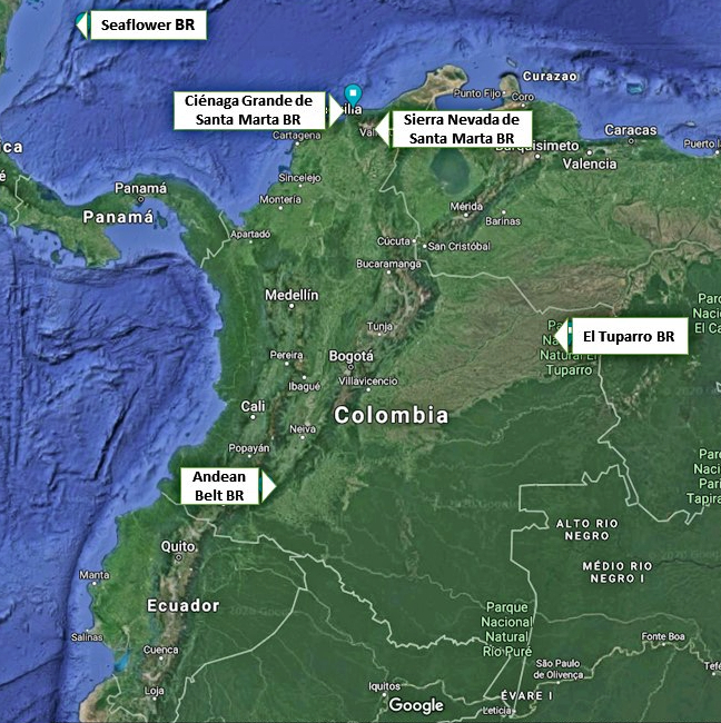
Tuparro Biosphere Reserve of the World

The park was created in 1970 to advance scientific studies and conserve the region’s biodiversity. This led to its declaration as El Tuparro National Natural Park in 1980 with 548,000 ha. The cultural and biological richness of this region made it worth to be declared a national monument, and core area of a Biosphere Reserve. Know more about biosphere reserves of Colombia in our entry Next Travel Ideas? Visit the Biosphere Reserves of Colombia.

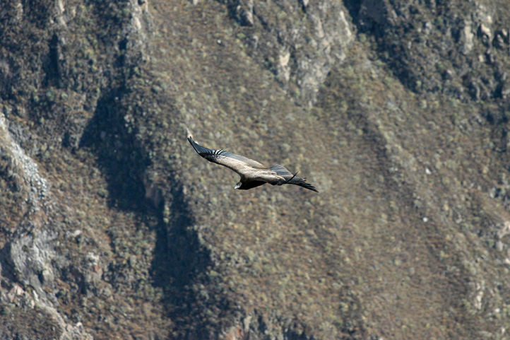
It is also considered an Important Bird Area (IBA) site because it is estimated that there are more than 320 species of birds, many of them associated with the water bodies.

A Sanctuary for All

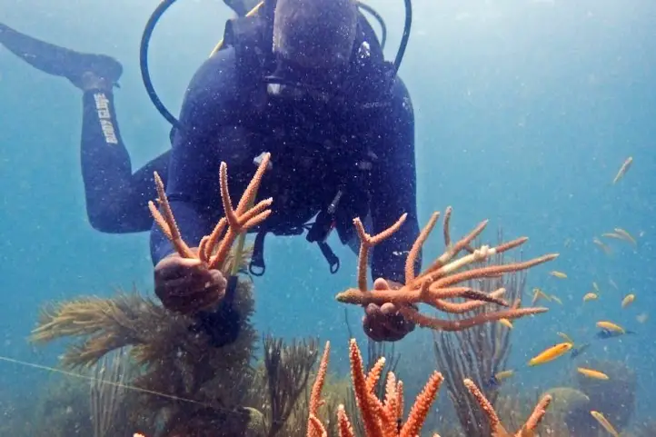
The park is a sanctuary for birds, orchids, monkeys, snakes and toninas (pink freshwater dolphins). There is also an ancient cemetery that belonged to the Maipur indigenous nation, which is now extinct.

Besides, there are indigenous communities surrounding the protected area: Piaroa, Curripaco, Cuiba, Puinave and Guahibo, who preserve and maintain their traditions amidst the park’s tourism.

What does it mean Tuparro?

This park owes its name to the Tuparro River. Tuparro is the name given to the small hills, rocky outcrops, of less than 900 m. high, which are remains of the ancient Guyanese shield, composed of quartz and currently considered one of the oldest mountains on the continent.

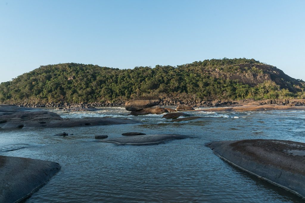
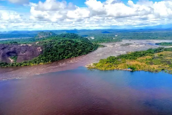
The Raudales de Maipures on the Orinoco River and at the mouth of the Tuparro River, is one of its main attractions. The Orinoco river narrows in this area and its current flows thunderously between giant rocks that extend up to 5 km.

How to Get to Tuparro National Natural Park

Via Bogotá-Puerto Carreño

Take a 1-hour flight from El Dorado International Airport (BOG) Bogotá to German Olano (PCR) at Puerto Carreño city with Colombia´s state own airline: Satena.

Once at the airport, take an approximately 45- minutes ride to Casuarito Port. Once at the Port you should take an extra 10-minutes boat ride to Puerto Ayacucho (Venezuela). Finally in Puerto Ayacucho you should take an extra 15-minutes boat ride to Tuparro.

Via Bogotá- Villavicencio

Take a 1,2-hours flight from El Dorado International Airport (BOG) in Bogotá to Vanguadía Airport (VVC) at Villavicencio city with Satena Airline. In the airport take an approximately 1h1min flight to to German Olano (PCR) at Puerto Carreño city with Satena Airline.

Once at the airport, take an approximately 45- minutes ride to Casuarito Port. Once at the Port you should take an extra 10-minutes boat ride to Puerto Ayacucho (Venezuela). Finally in Puerto Ayacucho you should take an extra 15-minutes boat ride to Tuparro.

What to do in Tuparro National Natural Park

During the induction talk, visitors are informed about the activities carried out in El Tuparro National Natural Park, the conservation objectives, the services offered, and the ecotourism activities that can be carried out.

Hiking and Trekking

Hiking is the most exciting activity in Tuparro National Natural Park. The Attalea (Maipures) trail has a length of 3 km uphill through a palm forest and rocky outcrop. Moderate intesity. When you reach the highest point you can have the view of the Raudal Maipures. This trail is currently being managed by local indigenous communities.

The Eighth Wonder of the World Tuparro Natural Park

The Raudal de Maipures and the Balancín

Formerly called Quituna by the indigenous people of the region, the waters of the Maipures raudal belong to the great Orinoco River. There, this riverbed marks part of the extensive border limits that separate Colombia and Venezuela.

Maipures is one of the most impressive attractions that El Tuparro National Natural Park offers to its visitors. In the 19th century, specifically in 1800, the famous German naturalist Alexander von Humboldt passed through the Maipures stream. He called this place “the eighth wonder of the world”. Among its main attractions, undoubtedly, is the “Balancín”, in the sector of the Atarrayadero, a rock that remains suspended over another, despite the strong currents with which the great Orinoco lambastes there.

The best time to enjoy all the splendor that Maipures offers is during the summer months (low water season due to the few rains that fall in this region), that is, between the months of December and March.

Birdwatching and Wildlife Tours

El Tuparro National Natural Park is a perfect place for those interested in fauna and flora. However, it is not easy to spot wildlife because most of them have crepuscular habits (dawn and dusk) and are elusive.

Birdwatchers will be able to enjoy some of the species since there are records of more than 300 species of birds. Research and monitoring have found 74 species of mammals, 17 species of reptiles, 229 species of fish, and up to 828 species of plants in the protected area. Insects have not yet been surveyed, so all the data that you document during your visit (citizen science) will be of help to continue to nourish the park’s lists.

The main ecosystems present in the park are typical of the Orinoco, including dry and flooded savannah, gallery forests, riparian forests, and rocky outcrops.

Aquatic Tourism

Finishing the hiking activity through the Anaconda trail, you can go through a path in the savannah where meters ahead the visitor will find the attractive blue well, ideal for a refreshing swim. The bathing activity can also be developed in the attractions of Bocas del Tomo, Raudal del Tuparro and caño Peinillas. Kayak can also be practiced in the Raudal del Tuparro.

El Tuparro

Research and Environmental Education

The protected area’s exuberant biodiversity and its conservation status make it a suitable place for scientific research. In addition, activities related to the Environmental Communication and Education Plan are carried out in coordination with educational institutions and in the development of the lines prioritized for the fulfillment of the institutional mission.

Where to stay in Tuparro National Natural Park

Tuparro Natural National Park does not currently offer accommodation for travelers, but it is possible to stay in Puerto Carreño. Therefore we recommend the following hotels:

  • El Lago
  • Cacique Samanare
  • Voragine

Best Time to Visit Tuparro National Natural Park

The best time to visit El Tuparro is the dry season which starts at the beginning of June until late of September and from the beginning of April until late of November, with temperatures around 25º C (77 ºF).

Tuparro National Natural Park Entrance fees

The entrance fee varies depending on the nationality and age of the visitors. These are the entrance fees for 2021:

  • Colombians, resident foreigners and tourists from Bolivia, Ecuador and Peru (ages 5 to 25): COP 10,000
  • Colombians, resident foreigners and tourists from Bolivia, Ecuador and Peru (over 25 years old): COP 16,000
  • Non-resident foreigners (over 5 years old): COP 46,500
  • Children under 5 years old and Colombians over 65 years old have free entrance presenting their IDs.

Before Visiting Tuparro National Natural Park Consider:

  • The entrance of Visitors only will be allowed if it is accompanied by an authorized touristic operator that meets the law requirements, the visitor who enters the park without a touristic operator will be returned by the Staff of the protected area.
  • Due to the security of the visitors and uncomfortable situations that have been presenting with our neighboring country, national parks authorities recommend not traveling to Venezuela.
  • You should avoid taking harmful elements that go against biodiversity, such as aerosols, guns, alcoholic beverages and hallucinogen substances.
  • The staff of the Park reserves the right of entrance and/or permanence to the people that are not mentioned in the entrance permit, this measurement also works for the cases when the total number of people does not matches the number indicated in the permit.
  • Due to evacuation of BIODEGRADABLE trash (bottles, batteries, cans, etc.), it is necessary to carry plastics bags.
  • If you enter through Venezuela, you must do so through a registered tour operator and under their security.
  • Consider wearing personal protective items (sunscreen, sunglasses, towel, insect repellent, and hat).
  • Bring along valid identification documents and health insurance.
  • It is recommended to be vaccinated against yellow fever, measles and tetanus.
  • If you take specific medications, take them with you a personal first aid kit.
  • Photos or videos for commercial or publication purposes must have prior permission from Parques Nacionales. The use of DRONES is not permitted in the Protected Areas for filming and/or photography activities of a private-recreational nature, without prior authorization.

Some prohibitions

Feeding, bothering or hunting animals, alcoholic drinks and drugs, throwing cigarette butts, burning garbage, felling, and capturing wildlife.

References
About the authors

Sara Colmenares

The current director of Sula. Doctor in Biological Sciences. Her main interests are to explore and understand the organism-environment interactions, taking advantage of emerging knowledge for the management and conservation of species and ecosystem services. She is currently working as a consultant in functional ecology, ecosystem services, and conservation projects in Colombia related to ecotourism and birdwatching.

Luisa Martin

Engineer, world traveler, amateur photographer, traveling blogger, and foody.

Unique destination in the Colombian Caribbean: Old Providence McBean Lagoon Park

Old Providence McBean Lagoon Park is the only National Natural Park, of the 59 in Colombia, located in the insular Caribbean and is part of the Seaflower Man and Biosphere Reserve, established by UNESCO in 2000. Know more about the biosphere reserves of Colombia in our entry Next Travel Ideas? Visit the Biosphere Reserves of Colombia.

In this blog I offer you a brief review about everything you need to know before visiting Old Providence McBean Lagoon National Natural Park in the Colombian Caribbean.

Discovering Old Providence McBean Lagoon National Natural Park

This protected area in unique and is the only one in the insular oceanic Caribbean of Colombia. It is located northwest of the island of Providencia archipelago of San Andrés, Providencia and Santa Catalina. The park has an extension of about 9,95 km² of land area of which 9,05km² are marine area.

The small part of its land area is known as Iron Wood Hill, which has the second largest barrier reef in the Caribbean, after Belize, protecting the coasts of the island of Providencia. Thanks to the large coral reef in this area, its waters turn from a dark blue to a translucent turquoise blue; that is why it is known as “the Sea of 7 colors“.

Ecosystems at Old Providence McBean Lagoon

The park has 4 ecosystems of the archipelago that can be appreciated during the traveler’s visit: mangrove forests, coral formations, seagrass meadows and a small extension of dry forest.

Dry forest

This is a typical tropical dry forest distributed between 0-100 meters above sea level, the extent of this ecosystem in the park is 4.96 km².

Mangrove

Mangroves are coastal tree formations with adaptations to filter saltwater flow. In the lower part of the McBean micro-cave it is possible to appreciate the mangroves with an extension of 4.07 km².

SeaGrass Beds

These are formations of phanerogams capable of carrying out their life cycle submerged in saline waters. In the Iron Wood Hill and McBean Mangrove sectors there is an area of 5 km² of these seagrasses.

Coral Reefs

These are communities made up of stony or hard corals, algae, octocorals and sponges. The park has coral formations in the reef lagoon and lagoon terrace occupying an area of 13.43 km² or 90.4% of the total protected area. The protection of the coral reefs were the main reason to declare the park as a protected area.

Thus, the park has been part of the Special Management Area of the Archipelago of San Andrés, Providencia and Santa Catalina since 1996, the Seaflower Biosphere Reserve since 2000 and the Seaflower Marine Protected Area of the Archipelago since 2004.

How to get to Old Providence McBean Lagoon National Natural Park

Bogotá-San Andres Island

Take a 1,2- hour flight from Bogotá to Gustavo Rojas Pinilla International Airport (ADZ) at San Andres Island. Once at the airport, tienes dos opciones para llegar al parque:

1. Take an extra 4-hour katamaran to Old Providence Mc Bean Lagoon.
2. Take a 30- minutes flight to El Embrujo Airport (PVA)

What to do in Old Providence McBean Lagoon National Natural Park

It has a 32-kilometer coral barrier reef and a small hill known as Iron Wood Hill. In this protected area, where there is a 48-hectare dry forest, you can go hiking, diving, snorkeling and bird watching, among other activities. The islanders limit construction and are owners of the entire hotel offer, to reduce the environmental impacts of tourism, a task they do hand in hand with travelers who know this natural wonder.

Diving and snorkeling

The park has 2 authorized dive sites with a maximum depth of 12 meter: Crab Cay and White Shoal (Hippie’s Place). There is a variety of reef species of wonderful colors and shapes for these activities. The transparency of its waters will leave you speechless, and the range of colors that you will be able to appreciate goes from deep blue to translucent sea water.

Among the species that can be observed are: Groupers, Chermas, anemones, mollusks, echinoderms and fish. The most important feature is the barrier reef, one of the largest in the world!

This not only gives it a permanent ecological importance, but also gives its waters an amazing aspect, making you able to see species with the naked eye without special equipment.

Corals of Peace, Diving with Purpose

Corales de Paz is a local foundation devoted to the conservation and research around the coral reefs in San Andres And Providencia. In 2020, it won with its initiative Seaflower Meaningful Diving (SMD) one of the most important awards recently offered for the reactivation of nature tourism in Colombia (Know more about in our entry The Top Post-Covid-19 Destinations for Conservation Lovers in Colombia).

Seaflower Meaningful Diving – Natural Wealth Award

“Seaflower Meaningful Diving, Diving with Purpose”, is focused on promoting collaboration between islanders, fishermen and tourists to fund projects for education, conservation, restoration and management of coral reefs in the Archipelago of San Andres, Providencia and Santa Catalina, through e-learning courses, complemented with gamification, allowing people to start their diving experience and preparation from home.

In the destination, travelers will be able to dive with Green Fins certified operators (as responsible and environmentally friendly dive operators), and receive the Reef Check EcoDivers (participatory coral monitoring) and/or the Reef Repair Divers (participatory coral reef restoration) certificates.

The first results of this project will be seen in 2022, so get ready!

Seaflower Meaningful Diving is the result of a strategic alliance between three organizations: the Corales de Paz Foundation, the local tour operator specialized in diving Paradis de Colors and the engineering and technological innovation company DeepCo.

Land and Maritime Hiking

Hiking is an exciting activity in Old Providence McBean Lagoon National Natural Park. You can hike only 1 trail: Iron Wood Hill. The round trip is about 3 km and medium degree of difficulty. During the tour it is possible to appreciate the mangrove and dry forest ecosystems along with the park’s terrestrial fauna.

Kayaking is also available at the park’s permitted sites: Crab Cay, White Shoal, Okay Point Land Trail dock at Iron Wood Hill and McBean Mangrove Land Trail overlook dock.

Birdwatching

According to the PROAVES and McNish registry, the park has 179 bird species, of which more than 156 are migratory. There are 22 locally registered marine species and 21 shorebirds; during the winter season, the number of birds in the park is reduced.

The archipelago has an endemic bird, the San Andrés Vireo (Vireo caribaeus) locally called Chincherry.

According to Proaves, San Andres is an important step area for migratory birds, and as part of the Biosphere Reserve “Seaflower”, in it was declared as an Important Bird Area -IBA by Birdlife in 2005.

Wildlife Observation

On the island it is possible to identify more than 2 species of bats, one of the most representative is the Jamaican fruit bat (Artibeus jamaicensis). There are 2 species of snakes Boa or Bowla (Boa constrictor), and the Black Blind Snake (Leptotyphlops goudotii spp. magnamaculata).

Only one type of amphibian, the Bolivian toad-frog (Leptodactylus bolivianus, synonym L. insularis), has been recorded around the park.

Black crabs or zombie crabs (Gecarcinus ruricola), which inhabit scattered stones throughout the park, are appreciated by visitors and are also part of the island’s economy, both for local consumption and for export to San Andres Island.

Where to stay in Old Providence McBean Lagoon National Natural Park

The park does not have lodging but you can stay on the islands of Providencia and Santa Catalina.

Providence Island offers a wide variety of accommodations. Our recommended options for you to stay in are:

  • Crab Cay Boutique Lodge
  • Cabañas Agua Dulce.

Best time to visit Old Providence McBean Lagoon National Natural Park

The park can be visited all year round, the dry months are from January to late June.

Old Providence McBean Lagoon National Natural Park Entrance fees

The entrance fee varies depending on the nationality and age of the visitors. These are the entrance fees for 2021:

  • Colombians, resident foreigners and tourists from Bolivia, Ecuador and Peru (ages 5 to 25): COP 5,500
  • Colombians, resident foreigners and tourists from Bolivia, Ecuador and Peru (over 25 years old): COP 11,500
  • Non-resident foreigners (over 5 years old): COP 19,000
  • Children under 5 years old and Colombians over 65 years old have free entrance presenting their IDs.

What to consider before visiting Old Providence McBean Lagoon National Natural Park

  • Try to collaborate with the conservation objectives of the area and be careful with the environment.
  • When snorkeling or scuba diving, stay away from coral reefs, avoid touching or breaking them, corals are very fragile and take a long time to grow.
  • Avoid buying handicrafts made with shells, corals, and/or animal, vegetable or mineral elements.To take any of the tours inside the park you must hire an authorized and certified guide.
  • Consider wearing personal protective items (sunscreen, sunglasses, towel, insect repellent, and hat).
  • Recommended the use of binoculars to admire animals’ behavior and beauty in their natural habitat.
  • Carry valid identity documents and health insurance. It is recommended to be vaccinated against yellow fever and tetanus.
  • If you take specific medications, take them with you.

Some prohibitions

Feeding, bothering or hunting animals, alcoholic drinks and drugs, throwing cigarette butts, burning garbage, felling, and capturing wildlife.

References
  • Colparques
  • Colombia travel
  • EcuRed
  • Corales de Paz
About the authors

Luisa Martin

Engineer, world traveler, amateur photographer, traveling blogger, and foody.

Sara Colmenares

The current director of Sula. Doctor in Biological Sciences. Her main interests are to explore and understand the organism–environment interactions, taking advantage of emerging knowledge for the management and conservation of species and ecosystem services. She is currently working as a consultant in functional ecology, ecosystem services, and conservation projects in Colombia related to ecotourism and birdwatching.

Next Travel Ideas? Visit the Biosphere Reserves of Colombia

Did you know that Colombia has as many as 5 biosphere reserves? Biosphere Reserves are terrestrial and marine ecosystems protected by the Countries and by the World Network of Biospheres, whose main function is the conservation of the planet’s biodiversity and sustainable use.

The Biosphere Reserves are internationally recognized within the framework of the United Nations Education, Scientific, and Cultural Organization’s (UNESCO) Man and Biosphere Program (MAB).

The Biosphere Reserves form a Global Network in which each country participates on a voluntary basis. Additionally, UNESCO has defined operational guidelines for Biosphere Reserves as a way to ensure better international cooperation. This also takes into account national laws, which play an important role in the status of a biosphere reserve.

But What are Exactly the Biosphere Reserves?

The biosphere reserves are the central instrument of the Man and Biosphere Program (MAB) of the United Nations Educational, Scientific and Cultural Organization (UNESCO), which was established in 1976 to promote sustainable regional development.

Biosphere reserves are extensive and representative areas of natural and cultural landscape, which must be safeguarded in the long term.

Moreover, biosphere reserves must achieve the three fundamental objectives of conservation, development, and logistics as follows:

  • From conservation, the reserve must ensure the genetic heritage and the refuge of natural and cultural landscapes. In turn, it must safeguard ecosystem services (i.e. clean water, clean air, food, recreation).
  • From development, it aims to apply sustainable ecological and socioeconomic techniques in all economic sectors.
  • From logistics, it must facilitate multidisciplinary research and educational activities.

They represent a reservoir of genetic resources and ecosystems and are also areas of sustainable land use, spaces for education, research, and recreation. The biosphere reserves are like “laboratories” where the flora and fauna found in this area are subjects of natural and scientific interest. Additionally, the integrated management of land, water, and biodiversity is studied at these reserves.

The Biosphere Reserves of Colombia

Colombia’s location towards the north of South American region is naturally surrounded by open water from two sides, from the Caribbean Sea and the Pacific Ocean. It also counts with important ecosystems such as the Biogeographic Chocó, the Andean Mountain range, the Eastern plains of Orinoquía, and the Amazon jungle, among the biggest ones.

This privileged biogeographic position of Colombia provides an ideal habitat for a diverse range of flora and fauna to flourish, and that is why it has 5 biosphere reserves that protect important and unique ecosystems existing in the Colombian territory.

Colombia’s Biosphere Reserves Map modified from Google Maps

Needless to say, these reserves surely deserve a visit. Check out this list of the 5 biosphere reserves of Colombia:

The Andean Belt Biosphere Reserve, declared by UNESCO in 1979

Location

The Andean Belt Biosphere Reserve is located in the Colombian massif in the south of the Andes. The Andean belt includes three national parks: La Cueva de los Guacharos Natural National Park, Puracé Natural National Park, and Nevado del Huila Natural National Park.

Highlights

Cueva de los Guacharos Natural National Park

Cueva de los Guácharos NNP was the first area in Colombia to be declared a national park in 1960.

The Cueva de los Guácharos park protects the Andean forest and paramos, from 1200 to 3800 masl. What stands out most is the protection of the extensive and almost extinct areas of Andean oak (Quercus humboldtii Bonpl., Fagaceae) and the endemic oak Colombobalanus excelsa Lozano, Fagaceae, a new species of oak described in the park in 1979.

Cueva de los Guácharos ©Parques Nacionales Archive

The park owes its name to the guácharo bird (Steatornis caripensis, order Caprimulgiformes, family Steatornithidae). This is a frugivorous, nocturnal bird that lives in caves and hollows. Its name is onomatopoeic, it is derived from the Quechua huach and means to scream or cry, because of its characteristic song. Something very interesting about these birds is that, like bats, they are guided by a system of echolocation.

Puracé Natural National Park

Puracé National Natural Park is a volcanic zone and protects high mountain ecosystems, as well as nationally threatened species such as the Colombian pine (Podocarpus oleifolius), the oak (Quercus humboldtii), the wax palm (Ceroxylon spp), and the tree fern (Cyathea spp), and animals such as the Andean Condor.

Andean Condor

Its name, in the Quechua language, means “mountain of fire”. The main rivers of Colombia are born there: Magdalena, Cauca, Patía and Caquetá and also 30 calm and clear lagoons, ideal for contemplation.

Within its marvelous landscape, the Coconucos volcanic chain rises, also known as the Serrania de los Coconucos, composed of 11 volcanoes. Of these, the most outstanding are the Sugar Loaf (5,000 meters / 16,404 feet above sea level), the Puracé (4,780 meters / 15,682 feet  above sea level) that is the only active one, and the Coconuco (4,600 meters / 15,091 feet above sea level).

Nevado del Huila Natural National Park

This snow-capped mountain has the largest glacier in the central mountain range of the Colombian Andes and is the second largest glacier in the country, after Cocuy.

Huila snow-capped mountain ©Parques Nacionales Archive

The park shelters a volcanic area with paramo, subpáramo, and Andean forest vegetation. It also overlaps with indigenous reserves in the departments of Tolima and Cauca. This park is closed to tourists.

Tourist Activities

  • Birdwatching (take a look on our trip Upper Magdalena Birdwatching Tour).
  • Trekking.
  • Botanic and scientific tours.
  • Community-based tourism.
  • Cultural Heritage Observation.

El Tuparro Biosphere Reserve, declared by UNESCO in 1979

Location

El Tuparro Biosphere Reserve is located in the eastern part of Colombia in the region of Orinoco in the Vichada department. The reserve is surrounded by the Tomo River to the north and the Caño Maipurés to the south. It is one of the few places in the world where the Amazon pink dolphin lives.

The Eighth Wonder of the World: Tuparro Natural Park ©CommonsWikimedia

Highlights

The park has numerous trails for bird watching and hiking. In the year 1800, standing in front of the imposing torrent that the natives called Quituna, in awe, the naturalist Alexander von Humboldt, described as the “Eighth Wonder of the World” what is known today as the Raudal de Maypures, one of the main attractions of the protected area.

Tourist Activities

  • Birdwatching.
  • Trekking.
  • Note: It is prohibited to visit the park for sportfishing. Don’t be fooled by unscrupulous offers.

The Sierra Nevada de Santa Marta Biosphere Reserve, declared by UNESCO in 1979

The mountainous system called the Sierra Nevada de Santa Marta is conceived as the ‘Ancestral Territory’ of the original peoples Iku (Arhuaco), Kággaba (Kogui), Wiwa and Kankuamo.

The Sierra Nevada de Santa Marta Biosphere Reserve is a pyramidal territory, isolated from the Andes, and considered the highest coastal mountain in the world. It is located to only 42 kilometers from the sea, and it rises abruptly from the coasts of the Caribbean Sea until reaching a height of 5,775 meters (18,946 feet) in its snowy peaks Bolívar and Columbus.

Sierra Nevada de Santa Marta

Location

To the north it is bordered by the Caribbean Sea and the plains of the Guajira peninsula; to the southeast it is framed by the courses of the Ranchería and Cesar rivers, and to the west, it borders the great alluvial plain of the Magdalena river and the Ciénaga Grande de Santa Marta.

Highlights

For the variety of ecosystems, thermal floors next to the sea, its singular beauty and cultural richness constitute it a unique territory. Its main attraction is a sacred site for the four indigenous peoples of the Sierra, this is the Teyuna Archaeological Park “Lost City”.

Tourist Activities

  • Hiking and Trekking at Teyuna Archaeological Park “Lost City”. For more tourist information about Tayrona Park and “Lost City treks” check our entries Best Time to Visit Tayrona Park to Avoid Crowds and Bad Weather and Travel Guide to The Lost City Trek – Ciudad Perdida – in Colombia.  
  • Birdwatching in Minca and surrounds. If you are looking for birdwatching tourist information in Sierra Nevada de Santa Marta visit our post: Colombia’s Prime Birding Destination: Sierra Nevada de Santa Marta.
  • Note: Natural National Parks of Colombia and the four indigenous groups of the Sierra Nevada de Santa Marta: Kogui, Arhuaco, Wiwa, and Kakuamo remind us that in the high parts of the Sierra Nevada de Santa Marta, including the lagoons, the páramos and the snow-capped mountains, tourism activities are NOT allowed due to the fragility of these ecosystems and the cultural importance. Entering these sectors constitutes an environmental infraction, according to the provisions of Decree 622 of 1977 – included in Decree 1076 of 2015

Ciénaga Grande de Santa Marta Biosphere Reserve, declared by UNESCO in 2000

The Ciénaga Grande de Santa Marta Flora and Fauna Sanctuary, together with the Salamanca Island Parkway – VIPIS, constitute the Nucleus Zones of the UNESCO-declared Biosphere Reserve and Ramsar Wetland of the Ciénaga Grande de Santa Marta Deltaic Complex.

Both recognitions highlights the importance for conservation of the Ciénaga Grande de Santa Marta at a national and international level. Know more about Ramsar Areas of Colombia in our entry Wetland Destinations in Colombia: Ramsar Areas of Colombia.

Ciénaga Grande de Santa Marta seen from Minca, Sierra Nevada de Santa Marta

Location

This Ciénaga Grande de Santa Marta Biosphere Reserve is located in the Caribbean region of Colombia, in the Department of Magdalena. It covers the municipalities of Ciénaga, Pueblo Viejo, Sitio Nuevo, Remolino, Salamina, El Piñón, Cerro de San Antonio, Concordia, Pivijay, El Retén, and Aracataca.

Highlights

The Ciénaga Grande de Santa Marta Flora and Fauna Sanctuary is formed by progressive accumulations of sediments from the Magdalena River. In turn, it is made up of mangrove ecosystems, swamps, rivers, canals, and marshy areas. It is part of a water complex of more than 100 swamps that present different levels of sedimentation and salinity.

Tourist Activities

  • Birdwatching.
  • Community-based tourism.
  • Note: It is not recommended to camp, nor to spend the night nearby because of the mosquitoes. There is also no place to stay. It is recommended to visit during the day, and stay in Barranquilla or Santa Marta.

Seaflower Biosphere Reserve, declared by UNESCO in 2000

The Seaflower Biosphere Reserve has become one of the most representative icons of marine protection in Colombia.

Conserving this set of ecosystems in the San Andres Archipelago is important for food security. Its economic valuation, because of the environmental services it provides, is estimated at more than $267 billion a year.

Seaflower Meaningful Diving – Natural Wealth Award

Location

This reserve is located in the department of San Andrés, Providencia and Santa Catalina Archipelago.

Highlights

Seaflower is the largest Biosphere Reserve in the world with 180,000 square kilometers. It has all the marine and coastal ecosystems representative of the tropical zone: coral reefs, mangroves, reef lagoons, sea grasses, wetlands, beaches, open sea, and tropical dry forest.

Seaflower Facts

  • 78% of the Colombian coral areas are in Seaflower.
  • It has the third-largest barrier reef in the world.
  • It has 57 species of coral, of which 90% are on the Red List of threatened species of the International Union for the Conservation of Nature (UICN).
  • Also, Seaflower has 407 species of fish, of the 600 estimated to exist in the Caribbean, and is home to 157 species of birds, of which 55% are threatened.
  • Its white beaches, attractive for tourism, owe their beauty to the calcareous contributions of coral.
  • It is estimated that its waters annually produce about 156 tons of lobster and 182 tons of fish through traditional fishing.

Old Providence McBean Lagoon National Natural Park

The Old Providence McBean Lagoon National Natural Park is the only nationally protected area in the Oceanic Caribbean of Colombia. It was declared a protected area in 1995, and became part of the “Seaflower” Biosphere Reserve in 2000.

Old Providence McBean Lagoon is formed by a small hill known as Iron Wood Hill, and the McBean Mangrove. In its marine portion, the Barrier Reef stands out, protecting the coasts of Providence Island, which is the second largest in the Caribbean with 32 km in length, after Belize.

This great coral reef, together with the reef lagoon that forms in front of the McBean mangrove, gives the sea a spectacular range of colors that go from deep blue to a translucent aquamarine green. It is thanks to this unique coloring that the Sea of Providence is known as “The Sea of Seven Colors”.

Tourist Activities

If you want to know more about the most incredible natural destinations in Colombia, plan your trip with us!


References


About the author

Sara Colmenares

Current director of Sula. Doctor in Biological Sciences. Her main interests are to explore and understand the organism – environment interactions, taking advantage of emerging knowledge for the management and conservation of species and ecosystem services. She is currently working as a consultant in functional ecology, ecosystem services and conservation projects in Colombia related to ecotourism and birdwatching.